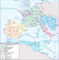
File:Mapa Imperio Occidental año 410.svg

Size of this PNG preview of this SVG file: 592 × 599 pixels. Other resolutions: 237 × 240 pixels | 474 × 480 pixels | 759 × 768 pixels | 1,012 × 1,024 pixels | 2,023 × 2,048 pixels | 1,220 × 1,235 pixels.
Original file (SVG file, nominally 1,220 × 1,235 pixels, file size: 960 KB)
File history
Click on a date/time to view the file as it appeared at that time.
| Date/Time | Thumbnail | Dimensions | User | Comment | |
|---|---|---|---|---|---|
| current | 06:41, 26 February 2020 |  | 1,220 × 1,235 (960 KB) | Paulusburg | Ajuste de la extensión del territorio controlado por Atalo y Alarico de acuerdo al edicto de Teodosio sobre reducción de impuestos a las provincias italianas saqueadas por los visigodos. Pequeños cambios estéticos y alguna errata. |
| 19:32, 9 February 2020 |  | 1,220 × 1,235 (937 KB) | Paulusburg | Añadir territorios controlados por: Bagaudas (Ralf Scharf 1993) Romanobritanos | |
| 05:50, 8 February 2020 |  | 1,220 × 1,235 (882 KB) | Paulusburg | Formato nombres diócesis y tribus | |
| 05:49, 6 February 2020 |  | 1,220 × 1,235 (867 KB) | Paulusburg | User created page with UploadWizard |
File usage
The following page uses this file:
Global file usage
The following other wikis use this file:
- Usage on de.wikipedia.org
- Usage on es.wikipedia.org
- Usage on fr.wikipedia.org
- Usage on nl.wikipedia.org
- Usage on sc.wikipedia.org


