
File:Lake Winnipeg map.png

Size of this preview: 575 × 600 pixels. Other resolutions: 230 × 240 pixels | 460 × 480 pixels | 1,000 × 1,043 pixels.
Original file (1,000 × 1,043 pixels, file size: 92 KB, MIME type: image/png)
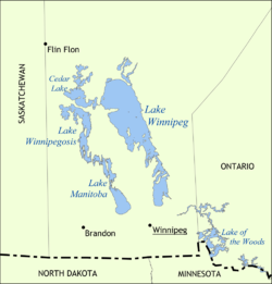
| Description | Map showing the location of Lake Winnipeg, Lake Manitoba, and Lake Winnipegosis in Manitoba, Canada. | ||
| Date | |||
| Source | Own work | ||
| Author | NormanEinstein | ||
| Permission (Reusing this file) |
I, the copyright holder of this work, hereby publish it under the following licenses: This file is licensed under the Creative Commons Attribution-Share Alike 3.0 Unported license.
You may select the license of your choice. |
||
| Other versions |
Derivative works of this file: |

File history
Click on a date/time to view the file as it appeared at that time.
| Date/Time | Thumbnail | Dimensions | User | Comment | |
|---|---|---|---|---|---|
| current | 15:41, 31 May 2006 | | 1,000 × 1,043 (92 KB) | NormanEinstein | Map showing the location of Lake Winnipeg, Lake Manitoba, and Lake Winnipegosis in Manitoba, Canada. Created by NormanEinstein, May 31, 2006. {{GFDL-self}} Category:Maps of Manitoba |
File usage
The following 6 pages use this file:
Global file usage
The following other wikis use this file:
- Usage on af.wikipedia.org
- Usage on ast.wikipedia.org
- Usage on az.wikipedia.org
- Usage on ba.wikipedia.org
- Usage on be.wikipedia.org
- Usage on bg.wikipedia.org
- Usage on br.wikipedia.org
- Usage on cs.wikipedia.org
- Usage on cv.wikipedia.org
- Usage on da.wikipedia.org
- Usage on el.wikipedia.org
- Usage on eo.wikipedia.org
- Usage on es.wikipedia.org
- Usage on fa.wikipedia.org
- Usage on fi.wikipedia.org
- Usage on fy.wikipedia.org
- Usage on gl.wikipedia.org
- Usage on hif.wikipedia.org
- Usage on hi.wikipedia.org
- Usage on hr.wikipedia.org
- Usage on hu.wikipedia.org
- Usage on hy.wikipedia.org
- Usage on id.wikipedia.org
- Usage on incubator.wikimedia.org
- Usage on is.wikipedia.org
- Usage on ja.wikipedia.org
View more global usage of this file.