
File:Fonstad Mount Doom detail.jpg
No higher resolution available.
Fonstad_Mount_Doom_detail.jpg (399 × 250 pixels, file size: 38 KB, MIME type: image/jpeg)
Summary
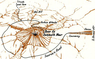
| Description | Detail of thematic journey map of Mount Doom by Karen Wynn Fonstad in The Atlas of Middle-earth |
|---|---|
| Author or copyright owner |
Karen Wynn Fonstad |
| Source (WP:NFCC#4) | Original publication: The Atlas of Middle-earth Immediate source: own scan of book |
| Date of publication | 1981 |
| Use in article (WP:NFCC#7) | The Atlas of Middle-earth |
| Purpose of use in article (WP:NFCC#8) | Illustrate cited discussion of text about Fonstad's thematic journey maps, showing her visual and cartographic approach |
| Not replaceable with free media because (WP:NFCC#1) |
All Fonstad's work is in copyright. |
| Minimal use (WP:NFCC#3) | This is a reduced detail of one map in the book. It's the only detail from Fonstad's book anywhere in Wikipedia. |
| Respect for commercial opportunities (WP:NFCC#2) |
The image is a small detail of one of many maps in the book. It has been in print since 1981 (1991 for the second edition), so it's hard to imagine that any commercial harm could be done by one image detail, rather the reverse actually. |
| Fair useFair use of copyrighted material in the context of The Atlas of Middle-earth//en.wikipedia.org/wiki/File:Fonstad_Mount_Doom_detail.jpgtrue | |
| Description | Detail of thematic journey map of Mount Doom by Karen Wynn Fonstad in The Atlas of Middle-earth |
|---|---|
| Author or copyright owner |
Karen Wynn Fonstad |
| Source (WP:NFCC#4) | Original publication: The Atlas of Middle-earth Immediate source: own scan of book |
| Date of publication | 1981 |
| Use in article (WP:NFCC#7) | Geography of Middle-earth |
| Purpose of use in article (WP:NFCC#8) | Illustrate cited discussion of the section (summarized from the article about the Atlas) about Fonstad's thematic journey maps, showing her visual and cartographic approach |
| Not replaceable with free media because (WP:NFCC#1) |
All Fonstad's work is in copyright. |
| Minimal use (WP:NFCC#3) | This is a reduced detail of one map in the book. It's the only detail from Fonstad's book anywhere in Wikipedia. |
| Respect for commercial opportunities (WP:NFCC#2) |
The image is a small detail of one of many maps in the book. It has been in print since 1981 (1991 for the second edition), so it's hard to imagine that any commercial harm could be done by one image detail, rather the reverse actually. |
| Fair useFair use of copyrighted material in the context of Geography of Middle-earth//en.wikipedia.org/wiki/File:Fonstad_Mount_Doom_detail.jpgtrue | |
Licensing
File history
Click on a date/time to view the file as it appeared at that time.
| Date/Time | Thumbnail | Dimensions | User | Comment | |
|---|---|---|---|---|---|
| current | 10:09, 29 October 2021 | | 399 × 250 (38 KB) | Chiswick Chap (talk | contribs) | Uploading a non-free file using File Upload Wizard |
You cannot overwrite this file.
File usage
The following 2 pages use this file: