
File:Enclosure Award and Map of Brockford Green, 1847.jpg

Size of this preview: 450 × 599 pixels. Other resolutions: 180 × 240 pixels | 360 × 480 pixels | 577 × 768 pixels | 769 × 1,024 pixels | 1,538 × 2,048 pixels | 6,944 × 9,248 pixels.
Original file (6,944 × 9,248 pixels, file size: 7.43 MB, MIME type: image/jpeg)
Summary
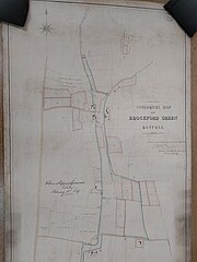
| Description | English: Enclosure award and map of Brockford Green (in the parish of Wetheringsett with Brockford), Suffolk. Map covers the enclosed area and some other land (64 acres) and shows the land after enclosure. Also shows lakes or ponds, field names, footpaths or bridleways, houses and uninhabited buildings (distinguished by colour), some named landowners. Includes a key to colouring. With border. Scale: 1 inch to 3 chains. By W S Grimwade, 1847. Map certified for accuracy, 28 February 1849. Valuer: William Sheppard Grimwade, Stonham Aspall, Suffolk, Land Surveyor |
| Date | |
| Source | National Archives [Reference: MAF 1/1055] |
| Author | Ministry of Agriculture, Fisheries and Food (MAFF) |
| Camera location | | View this and other nearby images on: OpenStreetMap |
|---|
Licensing
|
This work is in the public domain in its country of origin and other countries and areas where the copyright term is the author's life plus 70 years or fewer. | |
| This file has been identified as being free of known restrictions under copyright law, including all related and neighboring rights. | |
File history
Click on a date/time to view the file as it appeared at that time.
| Date/Time | Thumbnail | Dimensions | User | Comment | |
|---|---|---|---|---|---|
| current | 19:38, 20 May 2024 | | 6,944 × 9,248 (7.43 MB) | Maparchives | Uploaded a work by Ministry of Agriculture, Fisheries and Food (MAFF) from National Archives [Reference: MAF 1/1055] with UploadWizard |
File usage
The following page uses this file: