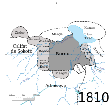
File:Borno in 1810.svg

Size of this PNG preview of this SVG file: 280 × 270 pixels. Other resolutions: 249 × 240 pixels | 498 × 480 pixels | 796 × 768 pixels | 1,062 × 1,024 pixels | 2,124 × 2,048 pixels.
Original file (SVG file, nominally 280 × 270 pixels, file size: 164 KB)
File history
Click on a date/time to view the file as it appeared at that time.
| Date/Time | Thumbnail | Dimensions | User | Comment | |
|---|---|---|---|---|---|
| current | 19:20, 19 February 2024 |  | 280 × 270 (164 KB) | Manlleus | File uploaded using svgtranslate tool (https://svgtranslate.toolforge.org/). Added translation for ca. |
| 19:19, 30 January 2011 |  | 280 × 270 (160 KB) | Arrantzaleak | Degrees | |
| 19:10, 30 January 2011 |  | 280 × 270 (163 KB) | Arrantzaleak | Font changed | |
| 22:22, 29 January 2011 |  | 280 × 270 (163 KB) | Arrantzaleak | ||
| 22:19, 29 January 2011 | 701 × 266 (163 KB) | Arrantzaleak | Category:Africa Category:Nigeria Category:Maps | ||
| 22:09, 29 January 2011 |  | 312 × 262 (163 KB) | Arrantzaleak | ||
| 22:02, 29 January 2011 |  | 312 × 262 (1.74 MB) | Arrantzaleak | ||
| 21:55, 29 January 2011 |  | 312 × 262 (1.81 MB) | Arrantzaleak | ||
| 21:49, 29 January 2011 |  | 312 × 262 (1.8 MB) | Arrantzaleak | {{Information |Description ={{en|1=Map of the Borno empire in 1810.}} {{de|1=Karte des Reiches Borno in 1810.}} {{es|1=Mapa del imperio de Borno en 1810.}} {{eu|1=Bornotar Inperioaren mapa 1810an.}} {{zh|1=尼日利亞(Borno)地图一八一〇年.}} {{ |
File usage
The following 3 pages use this file:
Global file usage
The following other wikis use this file:
- Usage on ar.wikipedia.org
- Usage on azb.wikipedia.org
- Usage on ca.wikipedia.org
- Usage on da.wikipedia.org
- Usage on de.wikipedia.org
- Usage on el.wikipedia.org
- Usage on es.wikipedia.org
- Usage on fr.wikipedia.org
- Usage on it.wikipedia.org
- Usage on ja.wikipedia.org
- Usage on ka.wikipedia.org
- Usage on lt.wikipedia.org
- Usage on no.wikipedia.org
- Usage on sv.wikipedia.org
- Usage on sw.wikipedia.org
- Usage on te.wikipedia.org
- Usage on tum.wikipedia.org


