
File:Anatolia 1097.svg

Size of this PNG preview of this SVG file: 800 × 416 pixels. Other resolutions: 320 × 166 pixels | 640 × 333 pixels | 1,024 × 533 pixels | 1,280 × 666 pixels | 2,560 × 1,332 pixels | 1,440 × 749 pixels.
Original file (SVG file, nominally 1,440 × 749 pixels, file size: 518 KB)
Summary
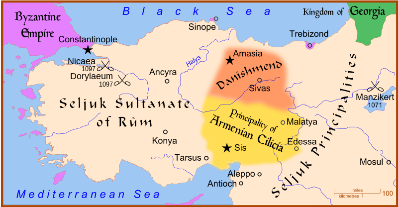
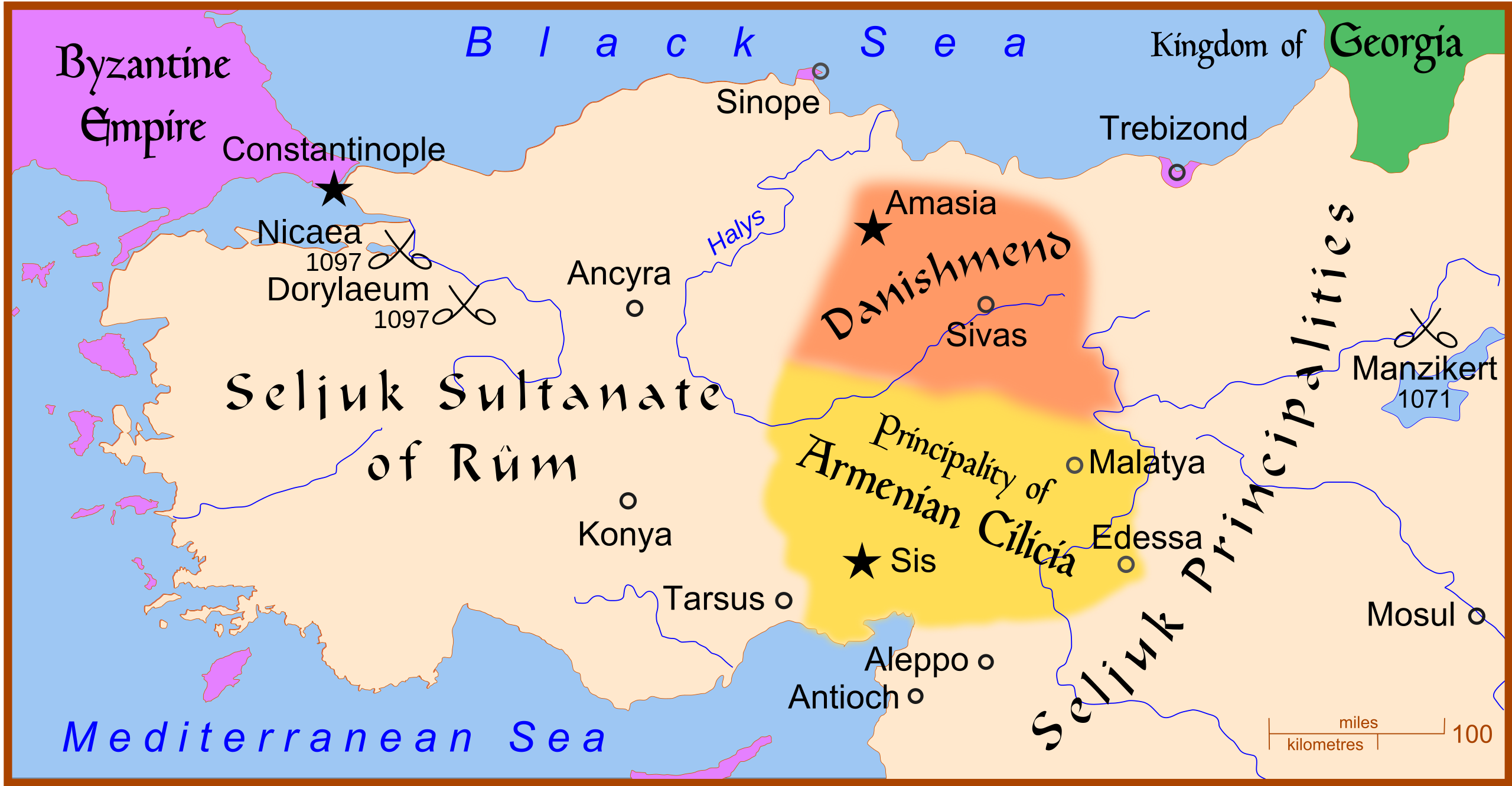
| Description | A map of Anatolia before the Siege of Nicaea in 1097, also showing the location of the Battle of Manzikert, 1071. |
| Date | |
| Source | Own work |
| Author | MapMaster |
| Other versions |
|


Other versions
- Danishmend locator map (without text)
- Map with placenames showing the states of Anatolia
- Versione italiana
References
- Hammond World Atlas Corporation (2007) Historical World Atlas, ISBN 9-780843-71391-6
- Fisher, Sydney Nettleton (1948) The Foreign Relations of Turkey 1481-1512, Internet Archive
The designation of Amasia as the main city of Danishmend is based on Fisher, p. 8.
Licensing
I, the copyright holder of this work, hereby publish it under the following licenses:

|
Permission is granted to copy, distribute and/or modify this document under the terms of the GNU Free Documentation License, Version 1.2 or any later version published by the Free Software Foundation; with no Invariant Sections, no Front-Cover Texts, and no Back-Cover Texts. A copy of the license is included in the section entitled GNU Free Documentation License. |
This file is licensed under the Creative Commons Attribution-Share Alike 4.0 International, 3.0 Unported, 2.5 Generic, 2.0 Generic and 1.0 Generic license.
- You are free:
- to share – to copy, distribute and transmit the work
- to remix – to adapt the work
- Under the following conditions:
- attribution – You must give appropriate credit, provide a link to the license, and indicate if changes were made. You may do so in any reasonable manner, but not in any way that suggests the licensor endorses you or your use.
- share alike – If you remix, transform, or build upon the material, you must distribute your contributions under the same or compatible license as the original.
You may select the license of your choice.
File history
Click on a date/time to view the file as it appeared at that time.
| Date/Time | Thumbnail | Dimensions | User | Comment | |
|---|---|---|---|---|---|
| current | 10:22, 8 July 2010 | | 1,440 × 749 (518 KB) | Malus Catulus | Fixed trebizond typo |
| 03:22, 27 February 2008 |  | 1,440 × 749 (520 KB) | MapMaster | more fixes, + river names | |
| 03:39, 26 February 2008 |  | 1,440 × 749 (520 KB) | MapMaster | Added Battle of Dorylaeum | |
| 02:43, 26 February 2008 |  | 1,440 × 749 (487 KB) | MapMaster | minor edits | |
| 00:36, 26 February 2008 |  | 1,440 × 749 (486 KB) | MapMaster | {{Information |Description=A map of w:en:Anatolia before the Siege of Nicaea in 1097. |Source=self-made |Date=25 February 2008 |Author= MapMaster |Permission= |other_versions= }} |
File usage
The following 8 pages use this file:
Global file usage
The following other wikis use this file:
- Usage on azb.wikipedia.org
- Usage on bg.wikipedia.org
- Usage on bn.wikipedia.org
- Usage on ca.wikipedia.org
- Usage on cs.wikipedia.org
- Usage on da.wikipedia.org
- Usage on de.wikipedia.org
- Usage on el.wikipedia.org
- Usage on es.wikipedia.org
- Usage on et.wikipedia.org
- Usage on eu.wikipedia.org
- Usage on fa.wikipedia.org
- Usage on fi.wikipedia.org
- Usage on fr.wikipedia.org
- Usage on he.wikipedia.org
- Usage on hy.wikipedia.org
- Usage on id.wikipedia.org
- Usage on ja.wikipedia.org
- Usage on ka.wikipedia.org
- Usage on ko.wikipedia.org
- Usage on lt.wikipedia.org
- Usage on nl.wikipedia.org
- Usage on no.wikipedia.org
- Usage on pa.wikipedia.org
View more global usage of this file.