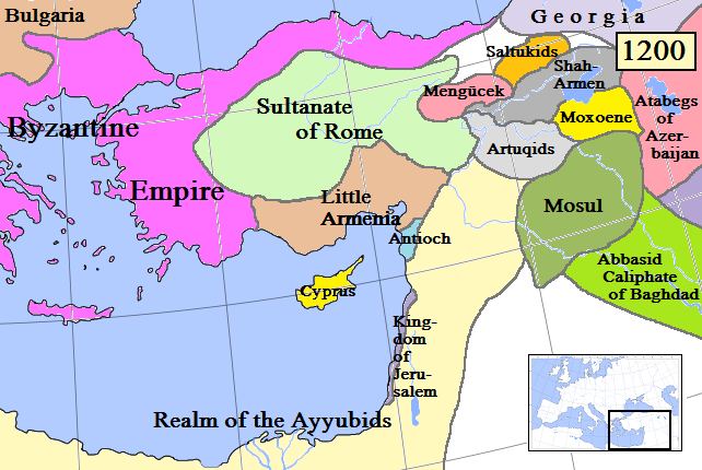
File:Anatolia1200.png
Anatolia1200.png (642 × 430 pixels, file size: 86 KB, MIME type: image/png)
File history
Click on a date/time to view the file as it appeared at that time.
| Date/Time | Thumbnail | Dimensions | User | Comment | |
|---|---|---|---|---|---|
| current | 15:55, 19 April 2009 |  | 642 × 430 (86 KB) | Gabagool | Added more names to states. Cyprus now yellow to match other maps better. |
| 22:37, 17 April 2009 |  | 642 × 430 (84 KB) | Gabagool | Extended Shah-Armen area per [http://en.wikipedia.org/wiki/Sassoun] ("The region was later ruled by the Mamikonian dynasty from around 772 until 1189/1190, when the Mamikonians moved to Cilicia after being dispossessed by Shah-Armen.") New Armenia -> Litt | |
| 23:54, 2 April 2009 |  | 642 × 430 (84 KB) | Gabagool | {{Information |Description={{en|1=Map of Anatolia and some surrounding regions in AD 1200. (Partially based on Euratlas map of Europe, 1200.)}} |Source=Own work by uploader |Author=Gabagool |Date=2009-04-03 |Permission= |other_versions= |
File usage
The following 8 pages use this file:
Global file usage
The following other wikis use this file:
- Usage on ar.wikipedia.org
- Usage on ast.wikipedia.org
- Usage on azb.wikipedia.org
- Usage on az.wikipedia.org
- Usage on be.wikipedia.org
- Usage on ca.wikipedia.org
- Usage on de.wikipedia.org
- Usage on el.wikipedia.org
- Usage on eo.wikipedia.org
- Usage on es.wikipedia.org
- Usage on et.wikipedia.org
- Usage on fa.wikipedia.org
- Usage on fr.wikipedia.org
- Usage on gl.wikipedia.org
- Usage on hy.wikipedia.org
- Usage on hyw.wikipedia.org
- Usage on it.wikipedia.org
- Usage on ja.wikipedia.org
- Usage on ka.wikipedia.org
- Usage on kk.wikipedia.org
- Usage on ko.wikipedia.org
- Usage on lt.wikipedia.org
- Usage on ml.wikipedia.org
- Usage on nl.wikipedia.org
- Usage on no.wikipedia.org
- Usage on pnb.wikipedia.org
- Usage on pt.wikipedia.org
- Usage on ro.wikipedia.org
- Usage on ru.wikipedia.org
- Usage on sh.wikipedia.org
- Usage on sl.wikipedia.org
View more global usage of this file.


