Dombóvár
Dombóvár | |
|---|---|
 Aerial view of Dombóvár | |
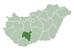
 Location of Tolna county in Hungary | |
| Coordinates: 46°22′55″N 18°08′32″E / 46.38196°N 18.14217°E | |
| Country | |
| County | Tolna |
| District | Dombóvár |
| Area | |
• Total | 78.48 km2 (30.30 sq mi) |
| Population (2004) | |
• Total | 17,041 (1 Jan. 2,024) |
| • Density | 263.18/km2 (681.6/sq mi) |
| Time zone | UTC+1 (CET) |
| • Summer (DST) | UTC+2 (CEST) |
| Postal code | 7200 |
| Area code | (+36) 74 |
| Website | www |
Dombóvár (German: Dombowa; Latin: Iowia) is a town in Tolna County, Hungary.
Dombóvár ( German :Dombowa) is a town in Tolna County , the seat of Dombóvár District . It is the third largest settlement in Tolna County , the county seat, after Szekszárd and Paks .
Archeologic excavations showed, that the Dombóvár area has been continuosly populated since the Stone Age.[1] During the Roman rule over Pannonia around 8 AD it was known as Pons Sociorum Mansuectina (Kapos River Crossing) because of bridge, that was built there. After the Roman withdrawal from the area, it was popuated by the Slavs, who named the settlement after oak trees (dobov(o) in proto-Slavic).[2]
In 1715, the settlement was granted market town status. After 1871, with the reorganization of the public administration and the establishment of civil administration, the market town status was permanently abolished, and Dombóvár officially became a large village, although the locals kept referring to it as a town. On April 1 , 1970 the Hungarian government officially elevated Dombóvár to the status of a town.
Twin towns – sister cities
 Kernen im Remstal, Germany
 Ogulin, Croatia
 Vir, Croatia
 Höganäs, Sweden
Notable people
- Ján Golian (1906–1945), Slovak Brigadier General and one of the most important figures of the Slovak National Uprising
- Zoltán Tildy, Jr. (1917–1994), photographer
Gallery
- Dombóvár in 1935
- Students in Dombóvár, 1975
- Dombóvár's railway station, 1973
References
- ^ https://hirado.hu/belfold/kozelet/cikk/2019/08/02/dombovar-tortenete-egeszen-az-oskorig-nyulik-vissza
- ^ https://ildikovamosi.hu/2-x-cac-national-dog-show-on-dombovar-on-11th-may-of-2024/
- ^ "Dombóvár testvérvárosai". dombovar.hu (in Hungarian). Dombóvár. Retrieved 2021-03-28.
External links
- Official website in Hungarian
- Street map (in Hungarian)


