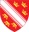
Bas-Rhin
Bas-Rhin 's Unterlànd, Unterelsàss, Ingerlànd | |
|---|---|
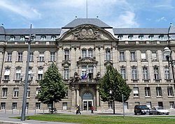 Prefecture building of the Bas-Rhin department, in Strasbourg | |
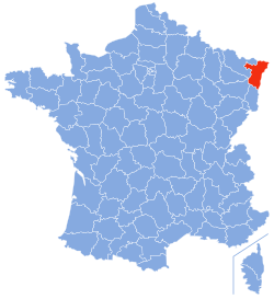 Location of Bas-Rhin in France | |
| Coordinates: 48°49′N 7°47′E / 48.817°N 7.783°E | |
| Country | France |
| Region | Grand Est |
| Prefecture | Strasbourg |
| Subprefectures | Haguenau Molsheim Saverne Sélestat |
| Government | |
| • Prefect | Josiane Chevalier[1] |
| Area | |
• Total | 4,755 km2 (1,836 sq mi) |
| Population (2022)[2] | |
• Total | 1,156,963 |
| • Rank | 19th |
| • Density | 240/km2 (630/sq mi) |
| Time zone | UTC+1 (CET) |
| • Summer (DST) | UTC+2 (CEST) |
| Department number | 67 |
| Arrondissements | 5 |
| Cantons | 23 |
| Communes | 514 |
| ^1 French Land Register data, which exclude estuaries, and lakes, ponds, and glaciers larger than 1 km2 | |
| Part of a series on |
| Alsace |
|---|
|
|
Bas-Rhin (French pronunciation: [bɑ ʁɛ̃] ⓘ)[3] is a département in Alsace which is a part of the Grand Est super-region of France. The name means 'Lower Rhine', referring to its lower altitude among the two French Rhine departments: it is downstream of the Haut-Rhin (Upper Rhine) department. Both belong to the European Upper Rhine region. It is, with the Haut-Rhin (Upper Rhine), one of the two departments of the traditional Alsace region which until 1871, also included the area now known as the Territoire de Belfort. The more populous and densely populated of the pair, it had 1,152,662 inhabitants in 2021.[4] The prefecture is based in Strasbourg. The INSEE and Post Code is 67.
On 1 January 2021, the departemental councils of Bas-Rhin and Haut-Rhin merged into the European Collectivity of Alsace.
The inhabitants of the department are known as Bas-Rhinois or Bas-Rhinoises.[5]
Geography
The Rhine has always been of great historical and economic importance to the area, and it forms the eastern border of Bas-Rhin. The area is also home to some of the foothills of the Vosges Mountains.
To the north of Bas-Rhin lies the Palatinate forest (Pfälzerwald) in the German State of Rhineland-Palatinate, and the German State of Baden-Württemberg lies to the east. To the south lies the department of Haut-Rhin, the town of Colmar and southern Alsace, and to the west the department of Moselle. On its south-western corner, Bas-Rhin also joins the departments of Vosges and Meurthe-et-Moselle.
Principal towns
The most populous commune is Strasbourg, the prefecture. As of 2021, there are 7 communes with more than 15,000 inhabitants:[4]
| Commune | Population (2021) |
|---|---|
| Strasbourg | 291,313 |
| Haguenau | 35,715 |
| Schiltigheim | 34,129 |
| Illkirch-Graffenstaden | 27,118 |
| Lingolsheim | 20,266 |
| Sélestat | 19,300 |
| Bischheim | 17,939 |
Climate
The Bas-Rhin has a continental-type climate, characterised by cold, dry winters and hot, stormy summers, due to the western protection provided by the Vosges. The average annual temperature is 10.4 °C (51 °F) in the lowlands (Entzheim) and 7 °C (45 °F) on high ground. The annual maximum temperature is high (30 °C (86 °F)). The average rainfall is 700 mm (27.56 in) per year.
Established according to data from the Infoclimat station at Strasbourg-Entzheim (the airport), over the period from 1961 to 1990.
| Lowest temperature | -23.2 °C |
| Coldest day | 2 January 1971 |
| Highest temperature | 37.4 °C |
| Hottest day | 2 July 1952 |
| Highest 24-hour rainfall | 62.9 mm |
| Wettest day | 23 May 1978 |
| Wettest year | 1987 (811.1mm) |
| Dryest year | 1949 (392.6mm) |
| Town | Sunshine (hours/yr) |
Rain (mm/yr) |
Snow (days/yr) |
Storm (days/yr) |
Fog (days/yr) |
|---|---|---|---|---|---|
| National average | 1,973 | 770 | 14 | 22 | 40 |
| Strasbourg | 1,693 | 665 | 29 | 29 | 56 |
| Paris | 1,661 | 637 | 12 | 18 | 10 |
| Nice | 2,724 | 767 | 1 | 29 | 1 |
| Brest | 1,605 | 1,211 | 7 | 12 | 75 |
| Climate data for Strasbourg | |||||||||||||
|---|---|---|---|---|---|---|---|---|---|---|---|---|---|
| Month | Jan | Feb | Mar | Apr | May | Jun | Jul | Aug | Sep | Oct | Nov | Dec | Year |
| Mean daily maximum °C (°F) | 4.5 (40.1) |
6.4 (43.5) |
11.4 (52.5) |
15.7 (60.3) |
20.2 (68.4) |
23.4 (74.1) |
25.7 (78.3) |
25.4 (77.7) |
21.0 (69.8) |
15.3 (59.5) |
8.8 (47.8) |
5.2 (41.4) |
15.3 (59.5) |
| Daily mean °C (°F) | 1.9 (35.4) |
2.9 (37.2) |
7.0 (44.6) |
10.5 (50.9) |
15.0 (59.0) |
18.1 (64.6) |
20.1 (68.2) |
19.8 (67.6) |
15.8 (60.4) |
11.2 (52.2) |
5.8 (42.4) |
2.8 (37.0) |
10.9 (51.6) |
| Mean daily minimum °C (°F) | −0.8 (30.6) |
−0.6 (30.9) |
2.5 (36.5) |
5.2 (41.4) |
9.8 (49.6) |
12.8 (55.0) |
14.5 (58.1) |
14.1 (57.4) |
10.6 (51.1) |
7.1 (44.8) |
2.8 (37.0) |
0.4 (32.7) |
6.5 (43.7) |
| Average precipitation mm (inches) | 32.2 (1.27) |
34.5 (1.36) |
42.8 (1.69) |
45.9 (1.81) |
81.9 (3.22) |
71.6 (2.82) |
72.7 (2.86) |
61.4 (2.42) |
63.5 (2.50) |
61.5 (2.42) |
47.0 (1.85) |
50.0 (1.97) |
665.0 (26.18) |
| Average precipitation days (≥ 1 mm) | 8.4 | 8.1 | 9.1 | 9.2 | 11.5 | 10.7 | 10.8 | 9.9 | 8.6 | 9.5 | 9.3 | 9.8 | 114.9 |
| Mean monthly sunshine hours | 58 | 84 | 135 | 180 | 202 | 224 | 229 | 220 | 164 | 99 | 55 | 43 | 1,693 |
| Source: Meteorological data for Strasbourg - 150m altitude, from 1981 to 2010 January 2015 (in French) | |||||||||||||
Etymology
Bas-Rhin is the last French department to have kept the term Bas meaning "Lower" in its name. Other departments using this prefix preferred to change their names - e.g.: Basses-Pyrénées in 1969 became Pyrénées-Atlantiques and Basses-Alpes in 1970 became the department of Alpes-de-Haute-Provence. The same phenomenon was observed for the inférieur (also meaning "lower") departments such as Charente-Inférieure, Seine-Inférieure, and Loire-Inférieure.
History
Bas-Rhin is one of the original 83 departments created on 4 March 1790, during the French Revolution.
On 14 January 1790 the National Constituent Assembly decreed:
- "- That Alsace be divided into two departments with Strasbourg and Colmar as their capitals;
- - That the Department of Strasbourg will be divided into three districts [...];
- - That the land of the German princes, coming under the sovereignty of France will be included in the division of districts;
- - That Landau, an enclave in the Palatinate, will have special justice [...]."
The borders of Bas-Rhin have changed many times:
- In 1793 it absorbed the following territories newly annexed by France:
- The County of Sarrewerden;
- The County of Drulingen;
- The lordship of Diemeringen;
- The lordship of Asswiller of the Steinkallenfels family;
- Several communes from the Palatinate[7]
- In 1795[8] the region of Schirmeck - where the people did not speak Alsatian - was detached from the district of Sélestat and attached to Vosges (District of Senones);[9]
- In 1808 some territories east of the Rhine were annexed, especially the city of Kehl;
- In 1814, after the first Treaty of Paris, France gained the territories north of the Lauter from the former department of Mont-Tonnerre and including the city of Landau,[10] but lost all the territories east of the Rhine;[11]
- In 1815, following the second Treaty of Paris, France lost all the territories north of the Lauter[12] and the department was occupied by troops from Baden and Saxony from June 1815 to November 1818.
- In 1871 Bas-Rhin was annexed by Germany (by the Treaty of Frankfurt) and then became Bezirk Unterelsass in Reichsland Elsaß-Lothringen;
- In 1919 Bas-Rhin became French again (Treaty of Versailles) and retained the territories that Germany had taken from the department of Vosges in 1871 (the Canton of Schirmeck and Canton of Saales);
- Between 1941 and 1944, the Natzweiler-Struthof concentration camp was in operation
- In 1944 Kehl was attached to Bas-Rhin before being reassigned to the new West Germany in 1953;
- In 1982 the department is included in the newly created Alsace region;
- On 7 April 2013 a referendum was held on the creation of a single community in Alsace for joining the Alsace region and the two departments of Haut-Rhin and Bas-Rhin.
Strasbourg, the chef lieu (principal city) of Bas-Rhin is the official seat of the European Parliament as well as of the Council of Europe.
Heraldry
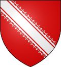 |
The coat of arms of Bas-Rhin is closely linked to the history of Basse-Alsace. It appeared for the first time in 1262 on a seal of the Counts of Werd who originated from Woerth near Erstein and who became landgrafs of Lower Alsace in 1156.
Blazon:
|
Demography
The demography of Bas-Rhin is characterized by high density and high population growth since the 1950s.
In January 2014 Bas-Rhin officially had 1,112,815 inhabitants and was 18th by population at the national level. In fifteen years, from 1999 to 2014, its population grew by more than 86,000 people, or about 5,800 people per year. But this variation is differentiated among the 517 communes that make up the department.
The population density of Bas-Rhin is 234 inhabitants per square kilometre in 2014 which is more than twice the average in France, which was 112 in 2009.
Changing demographics in Bas-Rhin
The first census was conducted in 1801 and this count, renewed every five years from 1821, provides precise information on the evolution of population in the department.
With 540,213 inhabitants in 1831, the department represented 1.66% of the total French population, which was then 32,569,000 inhabitants. From 1831 to 1866, the department gained 48,757 people, an increase of 0.26% on average per year compared to the national average of 0.48% over the same period.
Demographic change between the Franco-Prussian War of 1870 and the First World War was higher than the national average. Over this period, the population increased by 100,532 inhabitants, an increase of 16.74%, compared to 10% nationally. The population increased by 9.23% between the two world wars from 1921 to 1936 compared to a national growth of 6.9%.
Like other French departments, Bas-Rhin experienced a population boom after the Second World War, higher than the national level. The rate of population growth between 1946 and 2007 was 83.83%, compared to 57% nationally.
|
| |||||||||||||||||||||||||||||||||||||||||||||||||||||||||||||||||||||||||||||||||||||||||||||||||||||||||
| Source: SPLAF[13] and INSEE[14] | ||||||||||||||||||||||||||||||||||||||||||||||||||||||||||||||||||||||||||||||||||||||||||||||||||||||||||
Economy
The Bas-Rhin department has a high density of SMEs and SMIs and a higher proportion of workers in industry than the national average. Tourism activity is intense and creates many indirect jobs. The rate of unemployment is among the lowest in France: 6.5%. The average GDP per capita is €18,795 which places the region as the second largest in France with 2.9% of national GDP. Employment is distributed in the following way, as a percentage of the labor force: Agriculture: 8,411 or 2% Crafts and industry: 97,349 or 24.2% Building and Public Works: 23,928 or 6.0% Tertiary Sector: 271,984 or 67.8% Frontaliers:[15] 28,186
- Weighting of the major economic sectors[citation needed]
Trades: 11 358 companies comprising:
- Supply: 11%
- Production: 21%
- Building: 37%
- Services: 31%
Food industry : 568 units employing 15,884 employees
Commerce:
- Hypermarkets : 15
- Supermarkets : 117
- Other retail: 7,507 including non-food 5,229
Tourism: 3,216 hotels with 11,100 rooms
Law
Alsace and the adjacent Moselle department have a legal system slightly different from the rest of France. The statutes in question date from the period 1871–1919 when the area was part of the German Empire. With the return of Alsace-Lorraine to France in 1919, Paris accepted that Alsace and Moselle should retain some local laws in respect of certain matters, especially with regard to hunting, economic life, local government relationships, health insurance and social rights. It includes notably the absence of any formal separation between church and state: several mainstream denominations of the Christian church benefit from state funding, in contrast to principles applied in the rest of France.
Politics
Presidential elections 2nd round
| Election | Winning candidate | Party | % | 2nd place candidate | Party | % | |
|---|---|---|---|---|---|---|---|
| 2022 | Emmanuel Macron | LREM | 58.96 | Marine Le Pen | FN | 41.04 | |
| 2017[16] | Emmanuel Macron | LREM | 63.07 | Marine Le Pen | FN | 36.93 | |
| 2012 | Nicolas Sarkozy | UMP | 63.44 | François Hollande | PS | 36.56 | |
| 2007 | Nicolas Sarkozy | UMP | 65.58 | Ségolène Royal | PS | 34.42 | |
| 2002[16] | Jacques Chirac | RPR | 79.32 | Jean-Marie Le Pen | FN | 20.68 | |
| 1995[17] | Jacques Chirac | RPR | 58.97 | Lionel Jospin | PS | 41.03 | |
Current National Assembly Representatives
Administration
The seat of the General Council is located in Strasbourg, in a building designed by the architect Claude Vasconi. The current prefect of the Bas-Rhin is Stéphane Fratacci. The representative of the Lower Rhine for the National Youth Council is Mr. Gautier Lutz.
Bas-Rhin is composed of five arrondissements (Haguenau-Wissembourg, Molsheim, Saverne, Sélestat-Erstein, and Strasbourg)[19] and 23 cantons.[20]
Higher education
Through its secondary and higher education institutions, Alsace is a very important region for students and is very internationally oriented. Strasbourg alone welcomes 75% of students in its university. Since the merger of three faculties and the IUT of Illkirch and of Schiltigheim it has become one of the largest universities in France. There are also renowned institutions such as the National School of Administration (ENA), the National Institute of Territorial Studies (INET), the Higher European Institute of Management, and the National School of Physics of Strasbourg.
Tourism

The Château du Haut-Kœnigsbourg: built in the 12th century, the castle of Haut-Koenigsbourg dominates the plain of Alsace more than 700 metres (2,297 feet) above sea level. Destroyed during the Thirty Years' War, it was restored from 1900 to 1908 by the German Emperor Wilhelm II. It houses a large collection of weapons and period furniture.
The Château du Fleckenstein: early 12th century, built by the imperial family of Hohenstaufen, the castle was occupied and turned into an impregnable fortress by the Fleckenstein family. Many activities are offered such as the "Castle of challenges". There is a large selection of 20 games crossing the forest and in the secret rooms of the castle to discover life in the Middle Ages.
The Château de Lichtenberg: built in the early 13th century on a hill overlooking the village, the site includes contemporary space-related cultural activities.
With more than 27 million tourists per year, Bas-Rhin is the 5th largest French department for the number of room-nights for visitors per year.
Other sites of interest are:
- Château de La Petite-Pierre
- Château du Haut-Barr
- Château de Diedendorf
- Château d'Andlau
- Château de Kintzheim
Religious monuments

Strasbourg Cathedral: Strasbourg Cathedral is a masterpiece of Gothic art. Measuring 142 metres high from the Parvise to the top of the tower, it is considered the second largest cathedral in France after that of Rouen. Its astronomical clock dates from the Renaissance and the mechanism dated 1492 is a masterpiece in itself.
The Mont Sainte-Odile: a living spiritual place. Rising to 764 metres, this mountain in Vosges is topped by a monastery founded by Saint-Odile, the patron saint of Alsace. It is a tourist attraction and also a place of pilgrimage.
Museums
- Museums in Strasbourg
The Alsatian Museum: A museum of art and popular traditions. There is a large collection of utilitarian objects, decorative objects, as well as costumes that depict everyday life in Alsace in the 18th and 19th centuries.
The Strasbourg Museum of Modern and Contemporary Art: Located in the heart of the city of Strasbourg, the Museum of Modern and Contemporary houses nearly 18,000 works divided into three departments: fine arts, graphic art, and photography. Some of the greatest innovators of the 20th century are on display.
The Tomi Ungerer Museum: there is a large collection of drawings, archives, magazines, and toys donated to his hometown by the French illustrator Tomi Ungerer. It also hosts temporary exhibitions.
The Palais Rohan: The Rohan Palace was built between 1731 and 1742 at the request of Armand de Rohan-Soubise, Cardinal and Bishop of Strasbourg, who made his residence in the historic heart of the city. It also hosts the Arts and Crafts Museum, Archaeological Museum, and the Museum of Fine Arts.
Second homes
As of 2020, 3.3% of available housing in the department were second homes.[21]
| Town | Municipal population | Percentage of second homes |
|---|---|---|
| Wangenbourg-Engenthal | 1,332 | 23.6% |
| Grendelbruch | 1,218 | 17.2% |
| Bœrsch | 2,442 | 14.2% |
| Lembach | 1,548 | 12.8% |
| Entzheim | 2,453 | 12.2% |
Popular traditions
The stork
The stork is the emblematic bird of Alsace. According to legend, it brings newborn babies wrapped in a cloth tightly in its beak. Having disappeared from the local habitat; it has now returned, being protected and has become an integral part of the landscape. They can be seen mostly on the roofs of public buildings and more on houses.[23]
Traditional costume
The traditional Alsatian costume is a symbol of the region. Although it is usually composed of a black hat and a red skirt, the symbol of Alsace, there are many other outfits that vary between villages but also according to the social status of the person. Today virtually disappeared, they can still be seen in some villages at various events and through folk groups.
Festivals
Many traditions[24] have their origins in a quest for the meaning of life or in the rites of protection e.g. Christian festivals, even today create the rhythm of life in the villages of the region. The four seasons each have their share of celebrations: crop harvest, grape harvest, employers' feast days, crafts, yard sales, local produce.
- Covered Bridge at Strasbourg
- Church at Niederhaslach
- Clock Tower at Sélestat
See also
- Arrondissements of the Bas-Rhin département
- Cantons of the Bas-Rhin département
- Communes of the Bas-Rhin department sorted by arrondissements and cantons
- Communities of Communes of the Bas-Rhin département
- Haut-Rhin
References
- ^ Décret du 15 janvier 2020 portant nomination de la préfète de la région Grand Est, préfète de la zone de défense et de sécurité Est, préfète du Bas-Rhin (hors classe), Légifrance
- ^ "Populations de référence 2022" (in French). The National Institute of Statistics and Economic Studies. 19 December 2024.
- ^ traditional German: Niederrhein; Alsatian: Unterelsàss, ‘s Unterlànd or ‘s Ingerlànd; Office pour la Langue et la Culture d’Alsace. "Wàs brücht m'r im Elsàss? Petit lexique français-alsacien" (PDF). oclalsace.org (in French). Archived (PDF) from the original on 2022-10-09. Retrieved 10 December 2013..
- ^ a b "Populations légales en vigueur à compter du 1er janvier 2024: 67 Bas-Rhin" (PDF). INSEE. Retrieved 16 January 2024.
- ^ "Le nom des habitants des communes de France - Habitants". www.habitants.fr.
- ^ Paris, Nice, Strasbourg, Brest
- ^ Decree of 14 March 1793, which reunited 32 communes on the edge of the Rhine with France: "The National Convention, after hearing the report of the diplomatic committee, declares in the name of the people of France that it accepts the vote freely made by the sovereign people of the following towns and communes: Berglabren, Glengenmenster, Billirchein, Oberhofen , Barbelrod, Winten, Dierbach, Pleisweiler , Klingen, Oberhausen, Kleishorbach, Fiderhorbach, Kleiszellen, Kaplen, Herchiersveiler, Horbach, Erlebach, Mertzheim, Steinweiler , Volsfisbeim, Appenhoffen, Heichelheim, Mulheffen, Volmersheim, Nidershorst, Oberhorst, Effingen, Aldorff, Germersheim , Freisbach , Ilvesheim, their enclaves and dependencies; in their primary assemblies, for their reunification with France, and, accordingly, the said towns and communes are an integral part of the French Republic. - Commissioners of the National Convention in the departments of Meurthe, Moselle, and Bas-Rhin are responsible for taking all necessary measures for the execution of the laws of the Republic in those towns and communes as well as sending delegates to the National Convention to enable the setting up of a permanently organization. - These towns and communes form the fifth district of Bas-Rhin. The capital [of the district] will be Landau."
- ^ Decree of 30 Pluviôse III (18 February 1795), which reunites several communes in the District of Schelestadt with the district of Senones
- ^ Decree of 30 Pluviôse III (18 February 1795): "The communes of Russ, Wisches, Schirmeck, Rothau, Neuviller, Natzwiller, Wildersbach, Waldersbach, and Barembach, part of the district of Sélestat in the department of Bas-Rhin are to be reunited with the District of Senones in the Vosges department."
- ^ The Peace Treaty, signed in Paris on 30 May 1814, Article 3: "5° The Fortress of Landau, having been built before the year 1792, is an isolated point in Germany, France is to retain beyond its borders part of the Departments of Mont-Tonnerre and Bas-Rhin to link the fortress of Landau and its radius to the rest of the Kingdom. The new boundaries are, starting from a point near Obersteinbach (which remains outside the limits of France), the boundary between the department of Moselle and Mont-Tonnerre until the department of Bas-Rhin then following the line that separates the Cantons of Weissenbourg and Bergzabern (on the French side), the cantons of Pirmasens, Dahn, and Annweiler (on the German side), to the point where this line, near the village of Wolmersheim, touches the edge of the radius of the fortress of Landau. From this area, which remains as it was in 1792, the new frontier will follow the arm of the Queich river which, on leaving the radius near Queichheim (which remains in France), passes near the villages of Mertenheim, Knittelsheim, and Belheim (also remaining French) to the Rhine, which then continues to form the boundary of France and Germany."
- ^ The Treaty of Peace signed in Paris on 30 May 1814, Article 3: "5° [...] On the Rhine, the Thalweg will be the border so that any changes that may occur later in the course of the River will have no effect on the ownership of the islands therein. The state of possession of these islands will be established as it existed at the time of the signing of the Treaty of Luneville."
- ^ The Peace Treaty signed at Paris on 20 November 1815 Article I: "The borders of France will be as they were in 1790 except for changes and other matters which are summarized in this present article.
- 1. [...] Of the border of the country of Saarbrücken: the line of demarcation will be the same that now separates Germany from the departments of Moselle and Bas-Rhin to the Lauter [river], which will then serve as the border until its intersection with the Rhine. All the territory on the left bank of the Lauter, including Landau, will be part of Germany, but the city of Wissenbourg, traversed by the river, will remain wholly in France, with a radius on the left bank not exceeding one thousand Toises [two thousand metres], and will be specifically determined by the commissioners who are responsible for the final boundary.
- 2. From the mouth of the Lauter, along the departments of Bas-Rhin, Haut-Rhin, Doubs and Jura to the canton of Vaud [Switzerland], the boundaries remain as they were set by the Treaty of Paris. The Thalweg of the Rhine forms the boundary between France and the German states but the ownership of the islands, as will be fixed after a new survey of the course of the river, will remain unchanged with some changes to be submitted in the course of time. Commissioners will be appointed from both sides by the High Contracting Parties within a period of three months to proceed with such survey. Half the bridges between Strasbourg and Kehl belong to France, and the other half to the Grand Duchy of Baden [...]."
- ^ Historique du Bas-Rhin, SPLAF
- ^ Population en historique depuis 1968, INSEE
- ^ People who live in France and work in Germany
- ^ a b "Présidentielles".
- ^ "Résultats de l'élection présidentielle de 1995 par département - Politiquemania".
- ^ Nationale, Assemblée. "Assemblée nationale ~ Les députés, le vote de la loi, le Parlement français". Assemblée nationale.
- ^ Décret n° 2014-1722 du 29 décembre 2014 portant suppression des arrondissements de Strasbourg-Campagne et de Wissembourg (département du Bas-Rhin)
- ^ Décret n° 2014-185 du 18 février 2014 portant délimitation des cantons dans le département du Bas-Rhin
- ^ Catégories et types de logements, INSEE (in French)
- ^ "Statistiques locales: Part des résidences secondaires, population municipale". INSEE.
- ^ Official site for the protection and reintroduction of storks in Alsace-Lorraine (in French)
- ^ See Departmental Association for tourism Archived July 28, 2013, at the Wayback Machine (in French)
External links
- Prefecture website (in French)
(in English)
- Collectivité européenne d'Alsace (in French)
- Departmental Archives of Bas-Rhin (in French)
- Tourism Development agency for Bas-Rhin (in French)
- Official website for Tourism in Alsace (in French)


