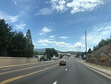
Star Valley, Arizona
Star Valley, Arizona | |
|---|---|
 Location of Star Valley in Gila County, Arizona | |
| Coordinates: 33°21′4″N 110°27′36″W / 33.35111°N 110.46000°W | |
| Country | United States |
| State | Arizona |
| Counties | Gila |
| Incorporated | 2005 |
| Government | |
| • Type | Council-manager |
| • Mayor | Bobby Davis |
| • Town Manager | Timothy Grier |
| Area | |
• Total | 36.15 sq mi (93.64 km2) |
| • Land | 36.14 sq mi (93.61 km2) |
| • Water | 0.01 sq mi (0.02 km2) |
| Elevation | 4,650 ft (1,420 m) |
| Population (2020) | |
• Total | 2,484 |
| • Density | 68.73/sq mi (26.54/km2) |
| Time zone | UTC-7 (MST (no DST)) |
| ZIP code | 85541[2] |
| Area code | 928 |
| FIPS code | 04-69480 |
| Website | starvalleyaz |

Star Valley is a town in Gila County, Arizona, United States, incorporated in 2005. Before incorporation, it was a census-designated place (CDP). As of the 2020 census the population of the town was 2,484.[3]
Geography
Star Valley is located in northern Gila County at 34°15′16″N 111°15′26″W / 34.25444°N 111.25722°W (34.254353, -111.257165).[4] It is bordered to the west by the town of Payson. Arizona State Route 260 passes through Star Valley, leading west 4 miles (6 km) into Payson and east 85 miles (137 km) to Show Low.
According to the United States Census Bureau, the town has a total area of 36.1 square miles (93.6 km2), of which 0.01 square miles (0.02 km2), or 0.03%, is water.[3] Star Valley sits at an elevation of 4,650 feet (1,420 m) and takes its name from the valley in which it is located, formed by Houston Creek, which descends to the south through Tonto National Forest to Tonto Creek, a tributary of the Salt River. The town was incorporated as the Town of Diamond Star, but changed its name to Star Valley in 2006.[5]

Demographics
| Census | Pop. | Note | %± |
|---|---|---|---|
| 2000 | 1,536 | — | |
| 2010 | 2,310 | 50.4% | |
| 2020 | 2,484 | 7.5% | |
| U.S. Decennial Census[6] | |||
As of the census[7] of 2000, there were 1,536 people, 677 households, and 421 families residing in the CDP. The population density was 241.9 inhabitants per square mile (93.4/km2). There were 1,017 housing units at an average density of 160.1 per square mile (61.8/km2). The racial makeup of the CDP was 93.6% White, 0.1% Black or African American, 0.7% Native American, 0.3% Asian, 0.1% Pacific Islander, 3.8% from other races, and 1.6% from two or more races. 10.3% of the population were Hispanic or Latino of any race.
There were 677 households, out of which 24.4% had children under the age of 18 living with them, 51.1% were married couples living together, 7.7% had a female householder with no husband present, and 37.8% were non-families. 32.1% of all households were made up of individuals, and 15.1% had someone living alone who was 65 years of age or older. The average household size was 2.27 and the average family size was 2.86.
In the CDP, the population was spread out, with 22.9% under the age of 18, 6.0% from 18 to 24, 21.9% from 25 to 44, 28.1% from 45 to 64, and 21.2% who were 65 years of age or older. The median age was 44 years. For every 100 females, there were 98.4 males. For every 100 females age 18 and over, there were 95.2 males.
The median income for a household in the CDP was $27,375, and the median income for a family was $32,045. Males had a median income of $30,966 versus $20,729 for females. The per capita income for the CDP was $19,414. About 4.7% of families and 9.7% of the population were below the poverty line, including 7.4% of those under age 18 and 6.5% of those age 65 or over.
Transportation
The Payson Senior Center operates the Beeline Bus, which provides local bus service between Payson and Star Valley.[8]
Government
Star Valley uses a council-manager government form with a town council. As of February 2020, the mayor is Gary Coon and the current town manager is Timothy Grier.[9][10]


Education
It is in the Payson Unified School District.[11] Payson High School is the zoned comprehensive high school.
References
- ^ "2020 U.S. Gazetteer Files". United States Census Bureau. Retrieved October 29, 2021.
- ^ "Star Valley AZ ZIP Code". zipdatamaps.com. 2023. Retrieved January 26, 2023.
- ^ a b "Explore Census Data". data.census.gov. Retrieved June 13, 2024.
- ^ "US Gazetteer files: 2010, 2000, and 1990". United States Census Bureau. February 12, 2011. Retrieved April 23, 2011.
- ^ "Archived copy". Archived from the original on January 13, 2014. Retrieved January 14, 2018.
{{cite web}}: CS1 maint: archived copy as title (link) - ^ "Census of Population and Housing". Census.gov. Retrieved June 4, 2016.
- ^ "U.S. Census website". United States Census Bureau. Retrieved January 31, 2008.
- ^ "Routes-Map". Deeline Bus. Retrieved January 27, 2020.
- ^ "Government – Town of Star Valley, Arizona". Town of Star Valley. Retrieved February 2, 2020.
- ^ "About – Town of Star Valley, Arizona". Town of Star Valley. Retrieved February 2, 2020.
- ^ "2020 CENSUS - SCHOOL DISTRICT REFERENCE MAP: Gila County, AZ" (PDF). U.S. Census Bureau. Retrieved September 12, 2024. - Text list


