Happisburgh Lighthouse: Difference between revisions
m →See also: Task 3: Fix CS1 deprecated coauthor parameter errors |
Barabbas1312 (talk | contribs) No edit summary |
||
| Line 3: | Line 3: | ||
| caption = |
| caption = |
||
| location = [[Happisburgh]], [[Norfolk]], [[England]] |
| location = [[Happisburgh]], [[Norfolk]], [[England]] |
||
| pushpin_map = Norfolk | pushpin = lighthouse |
|||
| latd =52 | latm =49 | lats = | latNS =N |
|||
| longd=1 | longm=32 | longs= | longEW=E |
|||
| coordinates = {{coord|52|49.17|N|01|32.32|E|region:GB_type:landmark}} |
| coordinates = {{coord|52|49.17|N|01|32.32|E|region:GB_type:landmark}} |
||
| yearlit = 1791 |
| yearlit = 1791 |
||
Revision as of 21:14, 25 June 2014
 | |
 | |
| Location | Happisburgh, Norfolk, England |
|---|---|
| Coordinates | 52°49.17′N 01°32.32′E / 52.81950°N 1.53867°E |
| Tower | |
| Constructed | 1791 |
| Construction | Masonry |
| Automated | 1929 |
| Height | 26 m (85 ft) |
| Shape | round |
| Operator | Trinity House (–1990), Happisburgh Lighthouse Trust (1990–) |
| Heritage | Grade II listed building |
| Light | |
| First lit | 1791 |
| Focal height | 41 m (135 ft) |
| Range | 14 nm (26 km) |
| Characteristic | White group flashing 3 times every 30 seconds |
Happisburgh Lighthouse in Happisburgh on the North Norfolk coast is the only independently operated lighthouse in Great Britain. It is also the oldest working lighthouse in East Anglia.
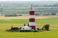
The lighthouse is painted white with three red bands and has a light characteristic of Fl(3)30s (3 white flashes, repeated every 30 seconds) at a height of 135 ft (41.1 m) with a range of 14 miles (22.5 km).[1]
History

The building was constructed in 1790 as one of a pair of candle-powered lights ("High Lighthouse" and "Low Lighthouse").[2] It was electrified in 1947. The tower is 85 ft (25.9 m) tall, putting the lantern at 134 ft (40.8 m) above sea level.[3] The other lighthouse - the "low light" was 20 ft (6.1 m) lower. It was decommissioned and demolished in 1883 before it could be lost due to coastal erosion, its lantern being reused at Southwold lighthouse.[4] Together they formed a pair of range lights that marked a safe passage around the southern end of the offshore Haisborough Sands 8 miles (12.9 km) to the safe waters of 'The Would'.[5]
Independence
In 1987 Happisburgh was one of five lighthouses declared redundant by Trinity House and deactivation was planned for June 1988. Villagers organised a petition to oppose the closure, and as a result the date was postponed.

Under the Merchant Shipping Act of 1894,[6] Trinity House may dispose of a working lighthouse only to an established Lighthouse Authority. On 25 April 1990 the Happisburgh Lighthouse Act[7] received the Royal Assent establishing the Happisburgh Lighthouse Trust as a Local Light Authority, and Happisburgh became the only independently run operational lighthouse in Great Britain.
In popular culture
- The lighthouse was used as the location for the video of Ellie Goulding's 2010 song The Writer.[8]
See also
- Price Edwards, E. (2010). lighthouse(1884). BiblioBazaar. ISBN 1-146-41637-7.
- Golding CBE, Capt. Thomas (1929). Trinity House from Within. private printing.
- Hague, Douglas B.; Christie, Rosemary (1975). Lighthouses - Their Architecture, History and Archaeology. Llandysul : Gomer Press. ISBN 0-85088-324-5.
- Long, Neville (1983). Lights of East Anglia. Terence Dalton Ltd. ISBN 0-86138-029-0.
- Stevenson, D. Alan (1959). The World's Lighthouses Before 1820. Oxford University Press.
References
- ^ Happisburgh Lighthouse website
- ^ http://www.british-history.ac.uk/mapsheet.aspx?compid=55129&sheetid=5983&ox=2925&oy=2631&zm=2&czm=2&x=393&y=277
- ^ "Lighthouses of the World & Fog Signals" - Alexander Finlay, Richard Holmes Laurie, 1888
- ^ Point 2 - The Lighthouse, BBC Suffolk. Retrieved 2012-10-29.
- ^ Happisburgh Village Website - History of Happisburgh Lighthouse
- ^ Merchant Shipping Act of 1894, part XI (p. 260 of the PDF version)
- ^ Happisburgh Lighthouse Act as annotation C9 modification of Merchant Shipping Act of 1894
- ^ "The Writer... prochain single d'Ellie Goulding". news-de-stars.com. 21 June 2010. Retrieved 3 July 2010.
External links
- Happisburgh Lighthouse website
- Trinity House Lighthouse Service
- An 1892 OS map, showing both the Happisburgh lighthouses ('England - Norfolk: 030/NW', Ordnance Survey 1:10,560 - Epoch 1 (1892)). Date accessed: 28 August 2010

