
Châtelet station: Difference between revisions
84.92.8.221 (talk) Undid revision 557870790 by 5.67.228.136 (talk) |
Epicgenius (talk | contribs) "circa" is used for times, not distances |
||
| Line 25: | Line 25: | ||
* lines 1, 4 and 14 towards [[Rue Saint-Denis (Paris)|Rue Saint-Denis]] and the [[Rue de Rivoli]]. |
* lines 1, 4 and 14 towards [[Rue Saint-Denis (Paris)|Rue Saint-Denis]] and the [[Rue de Rivoli]]. |
||
Châtelet is connected by another long underground corridor to the southern end of the [[RER]] station [[Châtelet - Les Halles (Paris RER)|Châtelet – Les Halles]], the northern end of which is again connected to the Métro station [[Les Halles (Paris Métro)|Les Halles]]. The |
Châtelet is connected by another long underground corridor to the southern end of the [[RER]] station [[Châtelet - Les Halles (Paris RER)|Châtelet – Les Halles]], the northern end of which is again connected to the Métro station [[Les Halles (Paris Métro)|Les Halles]]. The distance from [[Paris Métro Line 7|Line 7]] at Châtelet to the RER lines at [[Châtelet - Les Halles (Paris RER)|Châtelet – Les Halles]] is approximately {{convert|750|m}}. It is the ninth-busiest station on the Metro system. |
||
==History== |
==History== |
||
| Line 40: | Line 40: | ||
{{clear left}} |
{{clear left}} |
||
==Layout== |
|||
| ⚫ | |||
<!--lines 4 and 14 not included right now; to be added later--> |
|||
== |
===Lines 1, 7, and 11=== |
||
{|table border=0 cellspacing=0 cellpadding=3 |
|||
|style="border-bottom:solid 1px gray;border-top:solid 1px gray;" width=50 valign=top|'''Street Level''' |
|||
| ⚫ | |||
|} |
|||
| ⚫ | |||
{|table border=0 cellspacing=0 cellpadding=3 |
|||
|style="border-bottom:solid 1px gray;border-top:solid 1px gray;" width=50 valign=top|'''B1''' |
|||
| ⚫ | |||
|style="border-top:solid 1px gray;border-bottom:solid 1px gray;" width=100 valign=top|Connecting level |
|||
| ⚫ | |||
|} |
|||
{|table border=0 cellspacing=0 cellpadding=3 |
|||
|style="border-bottom:solid 1px gray;" width=50 rowspan=10 valign=top|'''Line 1 platforms''' |
|||
|style="border-top:solid 1px gray;border-right:solid 2px black;border-left:solid 2px black;border-bottom:solid 2px black;" colspan=2|<center><small>[[Side platform]], doors will open on the right</small> |
|||
|- |
|||
|style="border-bottom:solid 1px gray;" width=100|Westbound |
|||
|style="border-bottom:solid 1px gray;" width=390|← [[File:Metro-M.svg|20px]] [[File:Paris m 1 jms.svg|20px]] toward [[La Défense – Grande Arche (Paris Métro)|La Défense – Grande Arche]] <small>([[Louvre – Rivoli (Paris Métro)|Louvre – Rivoli]])</small> |
|||
|- |
|||
|Eastbound |
|||
|<span style="color:white;">→</span> [[File:Metro-M.svg|20px]] [[File:Paris m 1 jms.svg|20px]] toward [[Château de Vincennes (Paris Métro)|Château de Vincennes]] <small>([[Hôtel de Ville (Paris Métro)|Hôtel de Ville]])</small> → |
|||
|- |
|||
|style="border-top:solid 2px black;border-right:solid 2px black;border-left:solid 2px black;border-bottom:solid 1px gray;" colspan=2|<center><small>[[Side platform]], doors will open on the right</small> |
|||
|} |
|||
{|table border=0 cellspacing=0 cellpadding=3 |
|||
|style="border-bottom:solid 1px gray;" width=50 rowspan=10 valign=top|'''Line 11 platforms''' |
|||
|style="border-top:solid 1px gray;border-right:solid 2px black;border-left:solid 2px black;border-bottom:solid 2px black;" colspan=2|<center><small>[[Side platform]], doors will open on the right</small> |
|||
|- |
|||
|style="border-bottom:solid 1px gray;" width=100|Southbound |
|||
|style="border-bottom:solid 1px gray;" width=390|← [[File:Metro-M.svg|20px]] [[File:Paris m 11 jms.svg|20px]] Alighting passengers only</small> |
|||
|- |
|||
|Center track |
|||
|<span style="color:white;">→</span> [[File:Metro-M.svg|20px]] [[File:Paris m 11 jms.svg|20px]] toward [[Mairie des Lilas (Paris Métro)|Mairie des Lilas]] <small>(Hôtel de Ville)</small> → |
|||
|- |
|||
|style="border-top:solid 2px black;border-right:solid 2px black;border-left:solid 2px black;border-bottom:solid 1px bblack;" colspan=2|<center><small>[[Island platform]], doors will open on the left, right</small> |
|||
|- |
|||
|Northbound |
|||
|<span style="color:white;">→</span> [[File:Metro-M.svg|20px]] [[File:Paris m 11 jms.svg|20px]] toward [[Mairie des Lilas (Paris Métro)|Mairie des Lilas]] <small>(Hôtel de Ville)</small> → |
|||
|} |
|||
{|table border=0 cellspacing=0 cellpadding=3 |
|||
|style="border-bottom:solid 1px gray;" width=50 rowspan=10 valign=top|'''Line 7 platforms''' |
|||
|style="border-top:solid 1px gray;border-right:solid 2px black;border-left:solid 2px black;border-bottom:solid 2px black;" colspan=2|<center><small>[[Side platform]], doors will open on the right</small> |
|||
|- |
|||
|style="border-bottom:solid 1px gray;" width=100|Southbound |
|||
|style="border-bottom:solid 1px gray;" width=390|← [[File:Metro-M.svg|20px]] [[File:Paris m 7 jms.svg|20px]] toward [[Villejuif – Louis Aragon (Paris Métro)|Villejuif – Louis Aragon]] or [[Mairie d'Ivry (Paris Métro)|Mairie d'Ivry]] <small>([[Pont Marie (Paris Métro)|Pont Marie]])</small> |
|||
|- |
|||
|Northbound |
|||
|<span style="color:white;">→</span> [[File:Metro-M.svg|20px]] [[File:Paris m 7 jms.svg|20px]] toward [[La Courneuve – 8 Mai 1945 (Paris Métro)|La Courneuve – 8 Mai 1945]] <small>([[Pont Neuf (Paris Métro)|Pont Neuf]])</small> → |
|||
|- |
|||
|style="border-top:solid 2px black;border-right:solid 2px black;border-left:solid 2px black;border-bottom:solid 1px gray;" colspan=2|<center><small>[[Side platform]], doors will open on the right</small> |
|||
|} |
|||
==Gallery== |
==Gallery== |
||
| Line 61: | Line 101: | ||
</gallery> |
</gallery> |
||
| ⚫ | |||
==See also== |
|||
| ⚫ | |||
| ⚫ | |||
| ⚫ | |||
| ⚫ | |||
==Notes== |
==Notes== |
||
Revision as of 20:14, 26 August 2013
Template:Infobox Paris metro Châtelet is a station on lines 1, 4, 7, 11 and 14 of the Paris Métro in the centre of medieval Paris and the 1st arrondissement. The station is made up of two parts connected by a long corridor:
- lines 7 and 11 under the Place du Châtelet and the Quai de Gesvre (site of the original medieval river port of Paris), next to the Seine;
- lines 1, 4 and 14 towards Rue Saint-Denis and the Rue de Rivoli.
Châtelet is connected by another long underground corridor to the southern end of the RER station Châtelet – Les Halles, the northern end of which is again connected to the Métro station Les Halles. The distance from Line 7 at Châtelet to the RER lines at Châtelet – Les Halles is approximately 750 metres (2,460 ft). It is the ninth-busiest station on the Metro system.
History


The station was opened on 6 August 1900, three weeks after trains began running on the original section of line 1 between Porte de Vincennes and Porte Maillot on 19 July 1900. The line 4 platforms were opened on 21 April 1908 as part of the original section of the line from Porte de Clignancourt to Châtelet. It was the southern terminus of line 4 until the opening of the connecting section of the line under the Seine to Raspail on 9 January 1910.
The line 7 platforms were opened on 16 April 1926 as part of the line's extension from Palais Royal to Pont Marie with the name Pont Notre-Dame-Pont au Change. It had no direct connection with Châtelet. On 15 April 1934 a connecting corridor was opened to the platforms of lines 1 and 4 and the line 7 station was renamed. The line 11 platforms were opened near the line 7 platforms on 28 April 1935 as part of the original section of the line from Châtelet to Porte des Lilas.
On 9 December 1977 the Châtelet – Les Halles RER station was opened with a connecting corridor with a moving walkway to Châtelet. The line 14 platforms were opened near the line 1 and 4 platforms on 15 October 1998 as part of the original section of the line from Madeleine to Bibliothèque François Mitterrand. On 7 and 8 March 2009 the line 1 platforms were restored during the automation of line 1, including the installation of platform screen doors.
It is named after the Place du Châtelet, which is named after the Grand Châtelet, a castle over the northern approach to the old Pont au Change over the Seine to the Île de la Cité, which was demolished by Napoléon in 1802. Châtelet is a medieval French term for barbican, a small castle that commands (overlooks) a bridge or defile.[1]
Layout
Lines 1, 7, and 11
| Street Level |
| B1 | Connecting level |
| Line 1 platforms | ||
| Westbound | ← | |
| Eastbound | → | |
| Line 11 platforms | ||
| Southbound | ← | |
| Center track | → | |
| Northbound | → | |
| Line 7 platforms | ||
| Southbound | ← | |
| Northbound | → | |
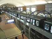
Gallery


 Line 14


See also
References
- Roland, Gérard (2003). Stations de métro. D’Abbesses à Wagram. Éditions Bonneton.
Notes
- ^ Jacques Hillairet, Dictionnaire historique des rues de Paris, 8th ed. (Éditions de Minuit, 1985), Vol. 1, pp. 331–34.
| Stations | |
|---|---|
| Stations |
|
|---|---|