
Santiago Metro Line 2: Difference between revisions
m removing orphan template as not a valid orphan |
m fix links |
||
| Line 46: | Line 46: | ||
The first section on Line 2 opened to the public on March 31, 1978<ref>[http://www.metrosantiago.cl/corporativo/historia Santiago’s Metro History (Spanish)] www.metrosantiago.cl Retrieved April 20, 2013</ref> running between [[Los Héroes metro station|Los Héroes station]] and [[Franklin metro station|Franklin station]]. Later the same year, in December, the next section opened running between [[Franklin metro station|Franklin station]] and [[Lo Ovalle metro station|Lo Ovalle station]]. |
The first section on Line 2 opened to the public on March 31, 1978<ref>[http://www.metrosantiago.cl/corporativo/historia Santiago’s Metro History (Spanish)] www.metrosantiago.cl Retrieved April 20, 2013</ref> running between [[Los Héroes metro station|Los Héroes station]] and [[Franklin metro station|Franklin station]]. Later the same year, in December, the next section opened running between [[Franklin metro station|Franklin station]] and [[Lo Ovalle metro station|Lo Ovalle station]]. |
||
In 1987, two new stations opened at the line’s northern end, [[Santa Ana metro station|Santa Ana]] and [[Puente Cal y Canto metro station|Puente Cal y Canto]]. Much later, on September 8, 2004, two further stations opened to the north, [[Patronato metro station |
In 1987, two new stations opened at the line’s northern end, [[Santa Ana metro station|Santa Ana]] and [[Puente Cal y Canto metro station|Puente Cal y Canto]]. Much later, on September 8, 2004, two further stations opened to the north, [[Patronato metro station|Patronato]] and [[Cerro Blanco metro station|Cerro Blanco]]. These stations marked a new milestone in Santiago engineering by travelling under the [[Mapocho River]] and the [[Costanera Norte|Costanera Norte highway]]. That year, the line also extended to the south with the opening of [[La Cisterna metro station|La Cisterna station]]. |
||
Another section opened in the north on November 25, 2005, running from [[Cerro Blanco metro station)|Cerro Blanco station]] to [[Einstein metro station|Einstein station]]. Finally, on December 22, 2006, the most recent three stations opened: [[Vespucio Norte metro station|Vespucio Norte]], [[Zapadores metro station|Zapadores]] and [[Dorsal metro station|Dorsal]]. |
Another section opened in the north on November 25, 2005, running from [[Cerro Blanco metro station)|Cerro Blanco station]] to [[Einstein metro station|Einstein station]]. Finally, on December 22, 2006, the most recent three stations opened: [[Vespucio Norte metro station|Vespucio Norte]], [[Zapadores metro station|Zapadores]] and [[Dorsal metro station|Dorsal]]. |
||
Revision as of 06:36, 28 May 2013
| Santiago Metro Line 2 | |||
|---|---|---|---|
 | |||
Line 2 | |||
| Overview | |||
| Status | Active | ||
| Owner | Empresa de Transporte de Pasajeros Metro S.A. | ||
| Locale | Santiago | ||
| Termini | |||
| Stations | 22 | ||
| Service | |||
| Type | rubber-tyred metro | ||
| System | Santiago Metro, Transantiago | ||
| Services | 1 | ||
| Operator(s) | Empresa de Transporte de Pasajeros Metro S.A. | ||
| Depot(s) | Lo Ovalle metro station | ||
| Rolling stock | Alstom NS-74, NS-2004 and Concarril NS-88 | ||
| History | |||
| Opened | March 15, 1978 | ||
| Technical | |||
| Track length | 19.3km | ||
| Character | Trench-Underground | ||
| Track gauge | 1,435 mm (4 ft 8+1⁄2 in) standard gauge | ||
| Operating speed | 75kmh | ||
| |||
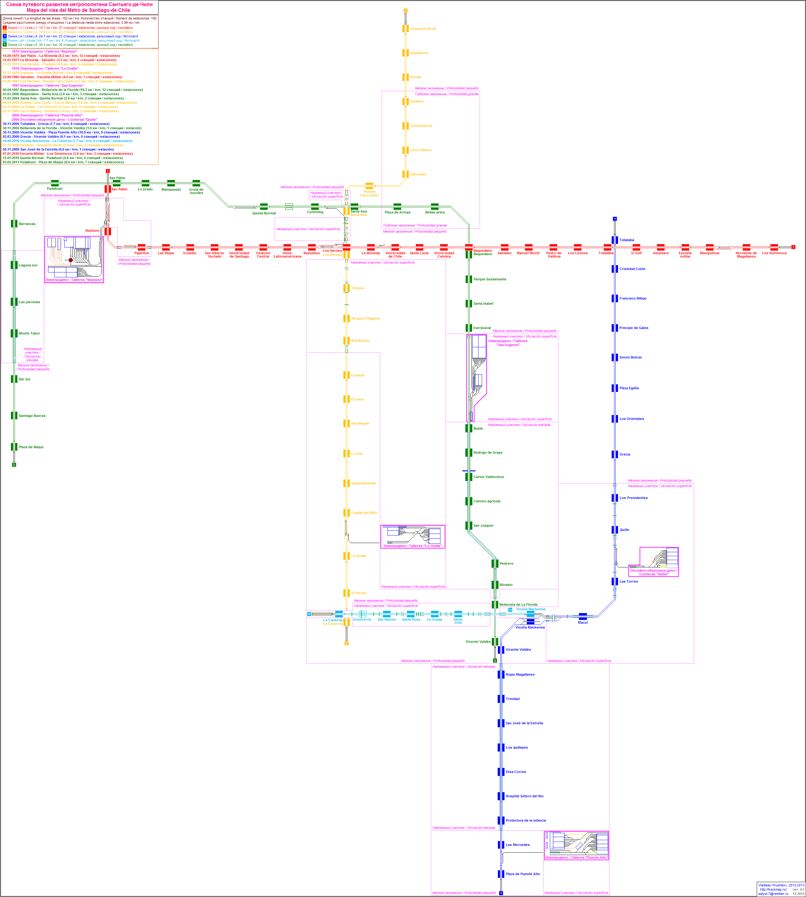
Santiago Metro Line 2 is one of the five lines that currently make up the Santiago Metro network in Santiago, Chile. It has 22 stations and 20.7 km of track. The line intersects with Line 1 at Los Héroes station, with Line 4A at La Cisterna station, and with Line 5 at Santa Ana station. It will also intersect with the future Line 6 at Franklin station and the future Line 3 at Puente Cal y Canto station. Its distinctive colour on the network map is yellow.
In 2011, Line 2 accounted for 18.8% of all trips made on the Santiago Metro.
History
The first section on Line 2 opened to the public on March 31, 1978[1] running between Los Héroes station and Franklin station. Later the same year, in December, the next section opened running between Franklin station and Lo Ovalle station.
In 1987, two new stations opened at the line’s northern end, Santa Ana and Puente Cal y Canto. Much later, on September 8, 2004, two further stations opened to the north, Patronato and Cerro Blanco. These stations marked a new milestone in Santiago engineering by travelling under the Mapocho River and the Costanera Norte highway. That year, the line also extended to the south with the opening of La Cisterna station.
Another section opened in the north on November 25, 2005, running from Cerro Blanco station to Einstein station. Finally, on December 22, 2006, the most recent three stations opened: Vespucio Norte, Zapadores and Dorsal.
On October 26, 2009, the express service began to run on Line 2, stopping at certain stations only at peak times, allowing for faster journeys. Since 2009, the Municipality of San Bernardo and the Santiago Metro began planning a future extension of Line 2 to the south, running from La Cisterna to San Bernardo’s central square. The extension will include several new stations which will benefit people living in southern Santiago, especially in the towns of El Bosque and San Bernardo.
Communes served by Line 2
This line serves the following communes from west to east:
Tren Expreso (Express Service)

The express service[2] works during peak hours and allows trains to stop at alternate stations, reducing the number of stops and the duration of journeys. The stations on the line are divided into “green route” stations, “red route” stations and “common” stations (Spanish: estación común), where all trains stop and allow passengers to switch between red and green routes. The express service works from Monday to Friday, between 6am - 9am and 6pm - 9pm.
Red Route Stations
- Vespucio Norte
- Zapadores
- Dorsal
- Cementerios
- Patronato
- Parque O'Higgins
- El Llano
- Lo Vial
- Ciudad Del Niño
Green Route Stations
Common Stations
There are 7 stations where both red and green route trains stop. They are the busiest stations and give commuters the chance to change between routes.
Stations
Line 2 stations from east to west are: