
Pyongyang: Difference between revisions
Superzohar (talk | contribs) No edit summary |
|||
| Line 203: | Line 203: | ||
In 676, Pyongyang was taken by Silla but left on the border between Silla and [[Balhae]] until the time of the [[Goryeo]] dynasty, when the city was revived as ''Sŏgyŏng'' (서경; 西京; "Western Capital"), although it was never actually a capital of Goryeo. It was the provincial capital of the [[Pyongan|Pyeongan Province]] during the [[Joseon dynasty]]. In 1890, the city had 40,000 inhabitants.<ref name="populstat.info">Jan Lahmeyer, University of Utrecht: [http://www.populstat.info/Asia/nkoreat.htm Populstat: North Korea - Urban Population]</ref> It was the site of an important battle during the [[First Sino-Japanese War]], which led to the destruction and depopulation of much of the city. However, it was the provincial capital of [[South Pyongan|South Pyeongan Province]] from 1896. Under [[Korea under Japanese rule|colonial rule]], the city became an industrial center, known in Japanese as Heijō. By 1938, Pyongyang had a population of 235,000.<ref name="populstat.info"/> |
In 676, Pyongyang was taken by Silla but left on the border between Silla and [[Balhae]] until the time of the [[Goryeo]] dynasty, when the city was revived as ''Sŏgyŏng'' (서경; 西京; "Western Capital"), although it was never actually a capital of Goryeo. It was the provincial capital of the [[Pyongan|Pyeongan Province]] during the [[Joseon dynasty]]. In 1890, the city had 40,000 inhabitants.<ref name="populstat.info">Jan Lahmeyer, University of Utrecht: [http://www.populstat.info/Asia/nkoreat.htm Populstat: North Korea - Urban Population]</ref> It was the site of an important battle during the [[First Sino-Japanese War]], which led to the destruction and depopulation of much of the city. However, it was the provincial capital of [[South Pyongan|South Pyeongan Province]] from 1896. Under [[Korea under Japanese rule|colonial rule]], the city became an industrial center, known in Japanese as Heijō. By 1938, Pyongyang had a population of 235,000.<ref name="populstat.info"/> |
||
In 1945, Pyongyang became the temporary capital of [[Provisional People's Committee for North Korea]]. It became the de facto capital of the Democratic People's Republic of Korea at its establishment in 1948. At that time, the Pyongyang government aimed to recapture Korea's official capital at that time, [[Seoul]]. Pyongyang was again severely damaged in the [[Korean War]], during which it was briefly occupied by South Korean forces. In 1952, it was the target of the largest aerial raid of the entire war, involving 1,400 UN aircraft. After the war, the city was quickly rebuilt with Soviet aid, with many buildings built in [[Socialist Classicism]]. The rebuilt city featured extensive parks, broad boulevards, and high-rise apartments. Pyongyang became the political, economic, and transportation center of North Korea. In 1962, the city had a population of 653,000. The population grew to 1.3 million in 1978 and to more than 3 million by 2007.<ref name="populstat.info"/> |
In 1945, the 25h army of the Soviet Army entered Pyongyang, and it became the temporary capital of [[Provisional People's Committee for North Korea]]. Pyongyang Commercial School was on Mansudae Hill, with the provincial government building behind. The provincial building was one of the finest buildings in Pyongyang. The [[Soviet Armed Forces]] assigned it as their headquarters and allotted [[City Hall]] to North Korean officials, while the Communist Party's headquarters were assigned to the Revenue Office.<ref>"The Red Army Descends on Pyongyang", Hwang Jang Yop's Memoirs</ref> It became the de facto capital of the Democratic People's Republic of Korea at its establishment in 1948. At that time, the Pyongyang government aimed to recapture Korea's official capital at that time, [[Seoul]]. Pyongyang was again severely damaged in the [[Korean War]], during which it was briefly occupied by South Korean forces. In 1952, it was the target of the largest aerial raid of the entire war, involving 1,400 UN aircraft. After the war, the city was quickly rebuilt with Soviet aid, with many buildings built in [[Socialist Classicism]]. The rebuilt city featured extensive parks, broad boulevards, and high-rise apartments. Pyongyang became the political, economic, and transportation center of North Korea. In 1962, the city had a population of 653,000. The population grew to 1.3 million in 1978 and to more than 3 million by 2007.<ref name="populstat.info"/> |
||
[[File:Pyongyang satellite image 2007-08-22.jpg|left|thumb|250px|Satellite view of Pyongyang (2007-08-22, [[Landsat 5]]).]] |
[[File:Pyongyang satellite image 2007-08-22.jpg|left|thumb|250px|Satellite view of Pyongyang (2007-08-22, [[Landsat 5]]).]] |
||
Revision as of 15:06, 19 January 2012
Pyongyang 평양 | |
|---|---|
| Pyongyang Directly Governed City | |
| transcription(s) | |
| • Chosŏn'gŭl | 평양직할시 |
| • Hanja | 平壤直轄市 |
| • McCune-Reischauer | P'yŏngyang Chikhalsi |
| • Revised Romanization | Pyeongyang Jikhalsi |
 From top left: Pyongyang's Skyline, Juche Tower, Kumsusan Memorial Palace, Arch of Triumph, Arch of Reunification, Tomb of King Dongmyeong, & Sunan International Airport | |
| Nickname(s): Ryŏkttongjŏk Rodong (력동적 로동) (Korean) " Dynamic Labors " | |
 Map of North Korea with Pyongyang highlighted | |
| Country | |
| Region | P'yŏngan |
| Founded | 1122 B.C. |
| Districts | |
| Area | |
• Total | 3,194 km2 (1,233 sq mi) |
| Elevation | 27 m (89 ft) |
| Population (2008) | |
• Total | 3,255,388 |
| • Density | 1,000/km2 (2,600/sq mi) |
| • Dialect | P'yŏngan |
Pyongyang (평양, Template:IPA-ko, literally: "Flat Land") is the capital of the Democratic People's Republic of Korea, commonly known as North Korea, and the largest city in the country. Pyongyang is located on the Taedong River and, according to preliminary results from the 2008 population census, has a population of 3,255,388.[1] The city was split from the South P'yŏngan province in 1946. It is administered as a directly governed city (chikhalsi), on the same level as provincial governments, not a special city (teukbyeolsi) as Seoul is in South Korea.
Historic names
One of Pyongyang's many historic names is Ryugyŏng (류경; 柳京), or "capital of willows", as willow trees have always been numerous throughout the city's history, and many poems have been written about these willows. Even today, the city has numerous willow trees, with many buildings and places having "Ryugyŏng" in their names. The most notable of these is the uncompleted Ryugyŏng Hotel. The city's other historic names include Kisŏng, Hwangsŏng, Rakrang, Sŏgyŏng, Sŏdo, Hogyŏng, and Changan.[citation needed] During the colonial period (1910–1945), Pyongyang was named Heijō.
Prehistory
In 1955, archaeologists excavated evidence of prehistoric occupation in a large ancient village called Kŭmtan-ni, in the Pyongyang area, from the Chŭlmun and Mumun pottery periods.[2] North Koreans associate Pyongyang with "Asadal" (아사달; 신시), or Wanggŏmsŏng (왕검성; 王儉城), the first capital (second millennium BC) of the Gojoseon kingdom according to Korean history books, notably Samguk Yusa. Many South Korean historians[who?] dispute this association, because other Korean history books[which?] place Asadal around the Liao River located in western Manchuria. Nevertheless, Pyongyang became a major city under Gojoseon.
History


No traces of the era of the Western Han dynasty have been found around Pyongyang. It is likely that the area of Pyongyang seceded from the disintegrating kingdom of Gojoseon and belonged to another Korean kingdom by the time of the fall of Wiman Joseon, the longest-lasting part of Gojoseon, after the Gojoseon-Han war in 108 BC. Several archaeological findings from the Later Eastern Han (25-220) periods in the Pyongyang area seems to suggest that Han forces later launched brief incursions around the area of Pyongyang.
The area around Pyongyang was called Nanglang during the early Three Kingdoms period. As the capital of Nanglang kingdom (낙랑국; 낙랑),[3] Pyongyang remained an important commercial and cultural outpost after Lelang was destroyed by an expanding Goguryeo in 313 AD.
Goguryeo moved its capital here in 427. According to Christopher Beckwith, Pyongyang is the Sino-Korean reading of the name they gave it in their language, Piarna, or "level land".[4]
In 676, Pyongyang was taken by Silla but left on the border between Silla and Balhae until the time of the Goryeo dynasty, when the city was revived as Sŏgyŏng (서경; 西京; "Western Capital"), although it was never actually a capital of Goryeo. It was the provincial capital of the Pyeongan Province during the Joseon dynasty. In 1890, the city had 40,000 inhabitants.[5] It was the site of an important battle during the First Sino-Japanese War, which led to the destruction and depopulation of much of the city. However, it was the provincial capital of South Pyeongan Province from 1896. Under colonial rule, the city became an industrial center, known in Japanese as Heijō. By 1938, Pyongyang had a population of 235,000.[5]
In 1945, the 25h army of the Soviet Army entered Pyongyang, and it became the temporary capital of Provisional People's Committee for North Korea. Pyongyang Commercial School was on Mansudae Hill, with the provincial government building behind. The provincial building was one of the finest buildings in Pyongyang. The Soviet Armed Forces assigned it as their headquarters and allotted City Hall to North Korean officials, while the Communist Party's headquarters were assigned to the Revenue Office.[6] It became the de facto capital of the Democratic People's Republic of Korea at its establishment in 1948. At that time, the Pyongyang government aimed to recapture Korea's official capital at that time, Seoul. Pyongyang was again severely damaged in the Korean War, during which it was briefly occupied by South Korean forces. In 1952, it was the target of the largest aerial raid of the entire war, involving 1,400 UN aircraft. After the war, the city was quickly rebuilt with Soviet aid, with many buildings built in Socialist Classicism. The rebuilt city featured extensive parks, broad boulevards, and high-rise apartments. Pyongyang became the political, economic, and transportation center of North Korea. In 1962, the city had a population of 653,000. The population grew to 1.3 million in 1978 and to more than 3 million by 2007.[5]

Geography and climate
| Pyongyang | ||||||||||||||||||||||||||||||||||||||||||||||||||||||||||||
|---|---|---|---|---|---|---|---|---|---|---|---|---|---|---|---|---|---|---|---|---|---|---|---|---|---|---|---|---|---|---|---|---|---|---|---|---|---|---|---|---|---|---|---|---|---|---|---|---|---|---|---|---|---|---|---|---|---|---|---|---|
| Climate chart (explanation) | ||||||||||||||||||||||||||||||||||||||||||||||||||||||||||||
| ||||||||||||||||||||||||||||||||||||||||||||||||||||||||||||
| ||||||||||||||||||||||||||||||||||||||||||||||||||||||||||||

Pyongyang is located in west-central North Korea; the city lies on a flat plain about 50 km (30 mi) east of the Korea Bay, an arm of the Yellow Sea. The Taedong River flows southwestward through the city toward the Korea Bay.
The climate of Pyongyang is a humid continental climate (Köppen climate classification Dwa). In winter, cold, dry winds can blow from Siberia, making conditions in winter very cold; the temperature is usually below freezing between November and early March, though the average daytime high is a few degrees above freezing in every month except January. The winter is generally much drier than summer, with snow falling thirty-seven days on average. The most unpleasant feature of the weather and climate is undoubtedly the extreme cold and frequent wind chill in winter; warm clothing is necessary at this time.[7]
The transition from the cold, dry winter to the warm, wet summer occurs rather quickly between April and early May, and there is a similar rather abrupt return to winter conditions in late October and November. Summers are generally hot and humid, with the East Asian monsoon taking place from June until August; these are also the hottest months, with average temperatures of 21 °C (70 °F) to 25 °C (77 °F), and daytime highs often above 30 °C (86 °F).
| Climate data for Pyongyang | |||||||||||||
|---|---|---|---|---|---|---|---|---|---|---|---|---|---|
| Month | Jan | Feb | Mar | Apr | May | Jun | Jul | Aug | Sep | Oct | Nov | Dec | Year |
| Mean daily maximum °C (°F) | −0.8 (30.6) |
2.4 (36.3) |
8.9 (48.0) |
17.1 (62.8) |
22.6 (72.7) |
26.7 (80.1) |
28.6 (83.5) |
28.9 (84.0) |
24.7 (76.5) |
18.2 (64.8) |
9.4 (48.9) |
1.7 (35.1) |
15.7 (60.3) |
| Mean daily minimum °C (°F) | −10.7 (12.7) |
−7.8 (18.0) |
−1.8 (28.8) |
4.9 (40.8) |
10.9 (51.6) |
16.5 (61.7) |
20.7 (69.3) |
20.5 (68.9) |
14.3 (57.7) |
6.7 (44.1) |
−0.3 (31.5) |
−7.2 (19.0) |
5.6 (42.1) |
| Average precipitation mm (inches) | 12.2 (0.48) |
11.0 (0.43) |
24.7 (0.97) |
49.9 (1.96) |
72.2 (2.84) |
90.3 (3.56) |
275.2 (10.83) |
212.8 (8.38) |
100.2 (3.94) |
39.9 (1.57) |
34.9 (1.37) |
16.5 (0.65) |
939.8 (37.00) |
| Average precipitation days | 5.2 | 4.2 | 5.1 | 6.7 | 8.1 | 8.7 | 14.4 | 11.0 | 7.2 | 6.1 | 7.3 | 5.9 | 89.9 |
| Source: World Meteorological Organisation[8] | |||||||||||||
Administrative divisions

P'yŏngyang is divided into 18 wards (ku- or guyŏk) (the city proper) and 1 county (kun or gun).[9]
|
|
Foreign media reports in 2010 stated that Kangnam-gun, Chunghwa-gun, Sangwŏn-gun, and Sŭngho-guyŏk had been transferred to the administration of neighboring North Hwanghae province.[10]
Culture
Landmarks
The capital has been completely redesigned since the Korean War (1950–1953). It is designed with wide avenues, imposing monuments, and monolithic buildings. The tallest structure in the city is the uncompleted 330-metre (1,083 ft) Ryugyŏng Hotel. This hotel has 105 floors and encloses 361,000 square metres (3,885,772 sq ft) of floor space. The original plan called for crowning it with seven revolving restaurants.
Notable landmarks in the city include:
- the Kumsusan Memorial Palace
- the Arch of Triumph (heavily inspired by but larger than Paris's Arc de Triomphe, and also inspired by the Welthauptstadt Germania project of Nazi Germany[citation needed])
- the reputed birthplace of Kim Il-sung at Mangyongdae Hill
- Juche Tower
- two large stadiums:
Pyongyang TV Tower is a minor landmark. Other visitor attractions include the Korea Central Zoo and the large golden statues of North Korea's first two leaders. The Arch of Reunification has a map of a united Korea supported by two concrete Korean women dressed in traditional dress straddling the multi-laned (but not completely paved) Reunification Highway, which stretches from Pyongyang to the Korean Demilitarized Zone (DMZ).
As of 2011 current construction includes claimed 100,000 new homes in the city, including a large project along Changjeon Street. This is the top construction priority and uses soldiers and university students as labor. Construction plans began after Kim Jong Il described the area as "pitiful".[11]
Cuisine

Pyongyang was the provincial capital of Pyeongan province until 1946.[12] Therefore, Pyongyang cuisine shares with the general culinary tradition of Pyeongan province. The most famous local food is Pyongyang naengmyeon, or also called mul naengmyeon or just simply naengmyeon. Naengmyeon literally means "cold noodles", while the affix, mul, refers to "water" because the dish is served in a cold broth. Naengmyeon consists of thin and chewy buckwheat noodles in a cold meat broth, and dongchimi (watery kimchi) and topped with a slice of sweet Korean pear. Pyongyang naengmyeon was originally eaten in homes built with ondol (traditional underfloor heating) during the cold winter, so it is also humorously called "Pyongyang deoldeori" (shivering in Pyongyang). Pyongyang locals sometimes enjoyed it as a haejangguk, which is any type of food eaten as a hangover cure, usually a warm soup.[13]
Another representative Pyongyang dish is Taedonggang sungeoguk, meaning "trout soup from the Taedong River". The soup is made with trout, which are abundant in the Taedong River, along with black peppercorns and salt.[14] It is served as a courtesy to important guests visiting Pyongyang. Therefore, the question, "How good was the trout soup?" is commonly used to greet people returning from Pyongyang. Another local specialty is Pyongyang onban (literally "warm rice of Pyongyang"). It is a dish made with freshly cooked rice topped with sliced mushrooms, chicken, and a couple of bindaetteok (pancakes made from ground mung beans and vegetables).[13]
Famous restaurants in the city include Okryugwan and Ch'ongryugwan.[15]
Sports
There are several sports clubs in Pyongyang, including the April 25 Sports Club, and the Pyongyang City Sports Club. The most popular sport in Pyongyang is Association football.
Transportation


Domestic trains
Pyongyang Station serves the main railway lines, including the Pyongui Line and the Pyongbu Line.
International trains
The city also has regular international rail services to Beijing and Moscow. A journey to Beijing takes about 25 hours and 25 minutes (K27 from Beijing/K28 from Pyongyang, on Mondays, Wednesdays, Thursdays and Saturdays); a journey to Moscow takes 6 days. The city also connects to the Eurasian Land Bridge via the Trans-Siberian Railway.
Metro and bus
The Pyongyang Metro is a two-line underground metro system which has a length of 22.5 km (14.0 mi). The Hyoksin line serves Kwangbok, Konguk, Hwanggumbol, Konsol, Hyoksin, Jonu, Jonsung, Samhung and Rakwon stations. The Chollima line serves Puhung, Yonggwang, Ponghwa, Sungni, Tongil, Kaeson, Jonu and Pulgunbyol stations.
There is also a 53 km (33 mi) long Pyongyang tram system and a 150 km (93 mi) Pyongyang trolleybus system. The trolley bus-stops are fairly busy. It is difficult to gauge how widely the metro is used, as tourists are permitted to travel only between designated stops with a guide.
Automobiles
There are few automobiles in the city, as cars are a symbol of status in the country due to their scarcity as a result of restrictions on import because of international sanctions and domestic regulations. Typically, only party bureaucrats drive automobiles.[2]
Air
State-owned Air Koryo has scheduled flights from Sunan Capital International Airport to Beijing (PEK), Shenyang (SHE), Vladivostok (VVO), Moscow (SVO), Bangkok (BKK), Khabarovsk (KHV), Kuala Lumpur (KUL), Shanghai (PVG) and Kuwait City (KWI)
Air Koryo also operates limited scheduled service to a few domestic destinations. The only domestic destinations are Hamhung, Wonsan, Chongjin, Hyesan and Samjiyon. In April 2008, Air China launched a regular service between Beijing and Pyongyang.
Gallery
 Pyongyang Station during the 1920s
 Pyongyang City Hall during the 1920s.
 Pyongyang Tram during the 1920s.
 Sŏsŏng ward during the 1920s.
 View of Pyongyang during the 1920s.
 View of Moran Hill on Spring during the 1920s.
 View of Moran Hill during the 1920s.
 Juche Tower, a reminder to the North Korean people of the philosophy of Juche (self-reliance)
 Arch of Reunification, a monument to the goal of a reunified Korea


- Ryugyŏng Hotel
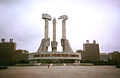 Monument to the Foundation of the Korean Workers' Party


Sister cities
 Kathmandu, Nepal[16]
 Jakarta, Indonesia
 Moscow, Russia
 Chiang Mai Province, Thailand
 Dubai, United Arab Emirates
 Tianjin, People's Republic of China[17]
 Baghdad, Iraq
See also
Notes
- ^ United Nations Statistics Division; Preliminary results of the 2008 Census of Population of the Democratic People’s Republic of Korea conducted on 1–15 October 2008 (pdf-file) Retrieved on 2009-03-01.
- ^ National Research Institute of Cultural Heritage. 2001. Geumtan-ri. Hanguk Gogohak Sajeon [Dictionary of Korean Archaeology], pp. 148–149. NRICH, Seoul. ISBN 89-5508-025-5
- ^ Nanglang-state is different from Lelang Commandery. Lelang Commandery was one of the four commanderies that Western Han instituted in the occupied territory of Wiman Joseon around the Liao river in western Manchuria in 108 BC.
- ^ Beckwith, Christopher I. (2009). Empires of the Silk Road: A History of Central Eurasia from the Bronze Age to the Present. Princeton University Press. p. 104. ISBN 9780691135892.
- ^ a b c Jan Lahmeyer, University of Utrecht: Populstat: North Korea - Urban Population
- ^ "The Red Army Descends on Pyongyang", Hwang Jang Yop's Memoirs
- ^ "Weather Centre - World Weather - Country Guides - North Korea". BBC. Retrieved 29 November 2010.
- ^ "World Weather Information Service - Pyongyang". July 2011.
- ^ "행정구역현황 (Haengjeong Guyeok Hyeonhwang)". NK Chosun. Retrieved 10 January 2006. Also Administrative divisions of North Korea (used as reference for hanja)
- ^ "Pyongyang now more than one-third smaller; food shortage issues suspected", Asahi Shinbun, 17 July 2010, retrieved 19 July 2010
- ^ Lee, Seok Young (25 August 2011). ""Pitiful" Changjeon Street the Top Priority". Daily NK. Retrieved 30 August 2011.
- ^ "평양시 平壤市" (in Korean). Nate/Encyclopedia of Korean Culture.
{{cite web}}: Unknown parameter|trans_title=ignored (|trans-title=suggested) (help) - ^ a b "닮은 듯 색다른 매력을 간직한 북한의 음식 문화" (in Korean). Korea Knowledge Portal. 19 June 2009.
{{cite web}}: Cite has empty unknown parameter:|trans_title=(help) - ^ Ju, Wan-jung (주완중) (12 June 2000). "'오마니의 맛' 관심" (in Korean). The Chosun Ilbo.
{{cite news}}: Unknown parameter|trans_title=ignored (|trans-title=suggested) (help) - ^ Lankov, Andrei (2007), North of the DMZ: Essays on daily life in North Korea, McFarland, pp. 90–91, ISBN 9780786428397
- ^ "International relations". Kathmandu City website. Retrieved 10 January 2006.[dead link]
- ^ First China-DPRK sister cities meeting held in Pyongyang [1].
Further reading
- Kracht, Christian, Eva Munz & Lukas Nikol. The Ministry Of Truth. Kim Jong Ils North Korea. Feral House, Oct 2007 ISBN 978-932595-27-7
- Springer, Chris. Pyongyang: The Hidden History of the North Korean Capital. Saranda Books, 2003. ISBN 963-00-8104-0.
- Willoughby, Robert. North Korea: The Bradt Travel Guide. Globe Pequot, 2003. ISBN 1-84162-074-2.
External links
- North Korea Uncovered, (North Korea Google Earth), a comprehensive mapping of North Korea, including all of the locations mentioned above, on Google Earth
- Holidays in Pyongyang
- Pyongyang travel guide at Wikitravel