
Ushi, Armenia: Difference between revisions
Content deleted Content added
mNo edit summary |
m +hy |
||
| Line 50: | Line 50: | ||
[[fr:Ushi]] |
[[fr:Ushi]] |
||
[[hy:Ուշի (գյուղ)]] |
|||
[[ru:Уши (село, Армения)]] |
[[ru:Уши (село, Армения)]] |
||
[[uk:Уші]] |
[[uk:Уші]] |
||
Revision as of 15:04, 27 April 2010
40°20′54″N 44°22′23″E / 40.34833°N 44.37306°E
Ushi Ուշի | |
|---|---|
 The village of Ushi. Smoke is from villagers burning dead plant material during the fall season. | |
| Country | Armenia |
| Marz (Province) | Aragatsotn |
| Population (2008) | |
• Total | 1,386 |
| Time zone | UTC+4 ( ) |
| • Summer (DST) | UTC+5 ( ) |
Ushi (Template:Lang-hy) is a town in the Aragatsotn Province of Armenia. Until the Russian conquest in 1828, Ushi was the administrative center of the Sayyidli-Aksakhali Mahal (district). The town contains a small 10th century chapel, and approximately 1 km outside of the village are the ruins of Saint Sargis Monastery of the 7th-13th centuries. Under the Chapel of Saint Sargis (the only structure still standing), is the grave and re-interred remains of the aforementioned saint. On top of the hill adjacent to the monastery complex are the collapsed remains of an Iron Age Fortress.
Gallery
 Ruins of the Saint Sargis monastic complex at Ushi of the 7th-13th c.
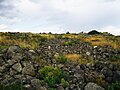 Iron Age Fortress of Ushi.


References
- Ushi, Armenia at GEOnet Names Server
- World Gazeteer: Armenia – World-Gazetteer.com
- Report of the results of the 2001 Armenian Census, Statistical Committee of Armenia
- Kiesling, Rediscoving Armenia, p. 21, available online at the US embassy to Armenia's website
