Saint-Prosper-de-Champlain
Saint-Prosper-de-Champlain | |
|---|---|
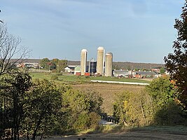 Agricultural zone, Rang Ste-Elisabeth | |
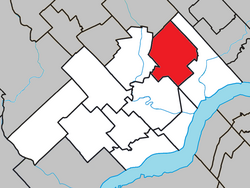 Location within Les Chenaux RCM | |
| Coordinates: 46°37′N 72°17′W / 46.617°N 72.283°W | |
| Country | |
| Province | |
| Region | Mauricie |
| RCM | Les Chenaux |
| Settled | c. 1850 |
| Constituted | July 1, 1855 |
| Government | |
| • Mayor | France Bédard |
| • Federal riding | Saint-Maurice—Champlain |
| • Prov. riding | Champlain |
| Area | |
• Total | 93.00 km2 (35.91 sq mi) |
| • Land | 94.11 km2 (36.34 sq mi) |
| There is an apparent contradiction between two authoritative sources | |
| Population (2021)[2] | |
• Total | 482 |
| • Density | 5.1/km2 (13/sq mi) |
| • Pop 2016-2021 | |
| • Dwellings | 264 |
| Time zone | UTC−5 (EST) |
| • Summer (DST) | UTC−4 (EDT) |
| Postal code(s) | |
| Area code | 418 |
| Highways | |
| Website | www |
Saint-Prosper-de-Champlain (French pronunciation: [sɛ̃ pʁɔspɛʁ də ʃɑ̃plɛ̃]) is a municipality of 482 people in the Les Chenaux Regional County Municipality, in Quebec, Canada. It is the smallest municipality in terms of population in the regional county.[3]
Before September 4, 2010, it was known simply as Saint-Prosper, on that date, the municipality of the parish of Saint-Prosper became the municipality of Saint-Prosper-de-Champlain.[4]
History
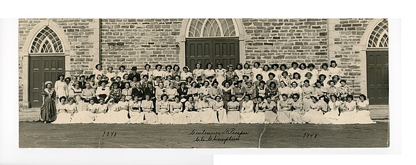
Around the Natal Church Bell Tower, historical notes on the parish of Saint-Prosper
« ... Et cependant que de progrès déjà accomplis au milieu de vous, non-seulement sous le rapport religieux; mais encore pour la vie matérielle ! Au dire de connaisseurs, vous êtes de tout mon diocèse les plus avancés en agriculture et en industrie laitière. Vos champs se couvrent d'abondantes moissons, malgré les intempéries des saisons et quelquefois les oppositions persistantes du sol; vos troupeaux ravissent les prix aux expositions; et vos produits laitiers, exportés par des vôtres sur les marchés étrangers, en rapportent de notables bénéfices.
Aussi l'aisance est générale à Saint- Prosper, et c'est à peine si on y trouve assez de nécessiteux, pour sauvegarder la parole de Notre-Seigneur; Pauperes enim semper habetis vobis (Jean-12-8) »
— F-X. Ev : des Trois-Rivières. Evêché des Trois- Rivières, 21 novembre 1908.[5]
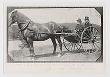
The area opened up for colonization in the middle of the 19th century, and in 1850 the Parish of Saint-Prosper was established out of the territories of Sainte-Geneviève-de-Batiscan and Sainte-Anne-de-la-Pérade. It was named after Prosper of Aquitaine possibly by Bishop Joseph Signay who wanted to emphasize the "prosperity" of the first settlers, who were poor but brave. In 1853, its post office opened, and two years later, the Parish Municipality of Saint-Prosper was formed, with Augustin Massicotte as first mayor.[6][7]
In 1861, Saint-Prosper had 1028 inhabitants, and at the start of 1900, there were nearly 1500 persons.[7]
On December 31, 2001, it was transferred from the Francheville Regional County to the new Les Chenaux Regional County, following the creation of the new City of Trois-Rivières and the dissolution of the Francheville RCM.[6]
Saint-Prosper-de-Champlain
- Wide open spaces in the St. Lawrence Lowlands
- Bike tour, activity organized by the Recreation Committee, rue de l'Église
- Catholic parish cemetery, rue de l'Église
- March 2008, rue Principale (Quebec road 159),
- Rural and agricultural zone, rang Saint-Charles
- Alte of a flock of snow geese, chemin des Trente-Trois
- Lake, creeks and rivers of the Sainte-Anne River drainage basin
- A la Barbotte Lake,[10] source of Gendron Creek, Laurentians, access by Route des Prairies
- Cossette Creek,[11] tributary of Gendron Creek, under the Saint-Prosper-de-Champlain Bridge (Trans Canada Trail)
- Charest River, tributary of Sainte-Anne River, from bridge TR-2/TR-1, Route Fraser
- Heritages, Structures, Traditions
- 1900, Farm Claïr Massicotte and Éléonore(Élée) Trudel, some of their 11 or 12 children, horses, dog and wheel, rang Saint-Augustin
- 1940, Main Street (Quebec Route 159), dirt roads, boardwalks, intersection of Route de l'Église
- Former railway line (CN)[14] converted to the Trans Canada Trail,[15] Saint-Prosper-de-Champlain Bridge, over Cossette Creek
Geography
The territory of Saint-Prosper-de-Champlain is mainly part of the Sainte-Anne River watershed. However, a small area to the west, bordering Saint-Stanislas and Sainte-Geneviève-de-Batiscan, is part of the Batiscanie region. The Charest River crosses the eastern part of the municipality from north-east to south-east.
Demographics
Population trend:[17]
- Population in 2021: 482 (2016 to 2021 population change: -9.1%)
- Population in 2016: 530
- Population in 2011: 505
- Population in 2006: 541
- Population in 2001: 531
- Population in 1996: 548
- Population in 1991: 584
- Population in 1986: 628
- Population in 1981: 663
- Population in 1976: 797
- Population in 1971: 886
- Population in 1966: 999
- Population in 1961: 1,129
- Population in 1956: 1,230
- Population in 1951: 1,172
- Population in 1941: 1,133
- Population in 1931: 1,167
- Population in 1921: 1,187
- Population in 1911: 1,316
- Population in 1901: 1,334
- Population in 1891: 1,358
- Population in 1881: 1,382
- Population in 1871: 1,147
- Population in 1861: 1,028
Private dwellings occupied by usual residents: 244 (total dwellings: 264)
Mother tongue:
- English as first language: 0%
- French as first language: 99%
- English and French as first language: 0%
- Other as first language: 0%
See also
External links
- Saint-Prosper-de-Champlain : la maison au cadran / Edgar Gariépy - photo 1926, Archives de Montréal
- Gendron Bridge at 2nd Row Saint-Édouard in Saint-Prosper, Champlain County, photo 1994, on BAnQ Quebec
- Saint-Prosper-de-Champlain, Répertoire des municipalités, Ministère des Affaires municipales et de l'Habitation Quebec
- Harmonized Regulations respecting Public Safety and Protection of Persons and Property, (in French), 22 décembre 2020. Note : Le présent règlement s’applique sur l’ensemble des territoires des municipalités de la MRC des Chenaux faisant partie de l’Entente relative à la fourniture de services de police par la Sûreté du Québec sur le territoire de la M.R.C., soit Batiscan, Champlain, Sainte-Anne-de-la-Pérade, Sainte-Geneviève-de-Batiscan, Saint-Luc-de-Vincennes, Saint-Maurice (Québec), Saint-Narcisse, Saint-Prosper-de-Champlain et Saint-Stanislas (Les Chenaux).
References
- ^ a b "Répertoire des municipalités: Geographic code 37250". www.mamh.gouv.qc.ca (in French). Ministère des Affaires municipales et de l'Habitation.
- ^ a b Statistics Canada 2021 Census - Saint-Prosper census profile
- ^ "Mauricie, Bulletin statistique régional, édition" (pdf). Gouvernement du Québec, Institut de la statistique du Québec. 2016. Retrieved 2023-09-29.
- ^ Quebec government (2010-11-12). "Saint-Prosper-de-Champlain" (in French). Commission de Toponymie Quebec. Retrieved 2023-09-29.
- ^ E. Taslusier (21 November 1908). "Autour du Clocher Natal, 376 pages" (pdf). Patrimoine Québec, Projet de sauvegarde de données généalogiques et d’archivage, p. 25. Retrieved 18 April 2023.
- ^ a b "Saint-Prosper (Municipalité de paroisse)" (in French). Commission de toponymie du Québec.
- ^ a b Gérard Ébacher. "Historique de Saint-Prosper" (in French). Municipalité de paroisse de Saint-Prosper. Archived from the original on 2009-05-01. Retrieved 2010-02-18.
- ^ "Chemin du Cordon". Commission de toponymie Quebec. Government of Quebec. Retrieved 4 September 2023.
- ^ "Chemin du Cordon". Hebdo Mékinac/Des Chenaux. Retrieved 4 September 2023.
- ^ Ministère de l'Énergie et des Ressources, Gouvernement du Québec, Service de la cartographie (1981). "A la Barbotte Lake, Saint-Adelphe 311 09-200-0201 Map -". BAnQ Banque de noms de lieux du Québec (in French). Retrieved 2023-09-29.
{{cite web}}: CS1 maint: multiple names: authors list (link) - ^ "Cossette Creek". Commission de Toponymie Quebec (in French). Quebec Government. 1968-12-05. Retrieved 2023-09-30.
- ^ "Ruisseau Gendron". Commission de toponymie Quebec (in French). Quebec Government. 1979-12-18. Retrieved 2023-09-30.
- ^ "Inventory and inspection of structures". Ministère des Transports et de la Mobilité durable (in French). Government of Quebec. 2023-09-30. Retrieved 2023-09-30.
- ^ "A Century of Our Stories 1919- 2019". Canadian National Railway (CN). 2019. p. 300. Retrieved 2023-10-06.
- ^ "The Pégase trails, the first section of the Trans Canada Trail in Mauricie" (in French). Trans Canada Trail. 2008-08-02. Retrieved 2023-10-22.
- ^ "Église Saint-Prosper". Répertoire du patrimoine culturel du Québec (in French). Gouvernement du Québec. 2013. Retrieved 2023-10-07.
- ^ Statistics Canada: 1996, 2001, 2006, 2011, 2016, 2021 census


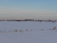


![A la Barbotte Lake,[10] source of Gendron Creek, Laurentians, access by Route des Prairies](https://upload.wikimedia.org/wikipedia/commons/thumb/8/8e/Laurentides_022.jpg/240px-Laurentides_022.jpg)
![Cossette Creek,[11] tributary of Gendron Creek, under the Saint-Prosper-de-Champlain Bridge (Trans Canada Trail)](https://upload.wikimedia.org/wikipedia/commons/thumb/a/ae/Sentier_transcanadien_021.jpg/240px-Sentier_transcanadien_021.jpg)
![Gendron Creek,[12] tributary of Charest River, from bridge P-17092,[13] Chemin Saint-Édouard](https://upload.wikimedia.org/wikipedia/commons/thumb/4/4b/Ruisseau_Gendron_015.jpg/240px-Ruisseau_Gendron_015.jpg)


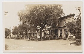
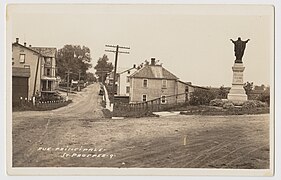
![Former railway line (CN)[14] converted to the Trans Canada Trail,[15] Saint-Prosper-de-Champlain Bridge, over Cossette Creek](https://upload.wikimedia.org/wikipedia/commons/thumb/9/96/Pont_Saint_Prosper_de_Champlain_001.jpg/240px-Pont_Saint_Prosper_de_Champlain_001.jpg)
![2020, time and wood donated each year (corvée), by parishioners, for the heating of the church,[16] rue de l'Église](https://upload.wikimedia.org/wikipedia/commons/thumb/2/2c/Corvee_bois_chauffage_052.jpg/240px-Corvee_bois_chauffage_052.jpg)