Redesdale
Redesdale | |
|---|---|
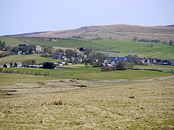
 The village of Elsdon in Redesdale | |
Location in Northumberland | |
| Coordinates: 55°13′44″N 2°11′10″W / 55.229°N 2.186°W | |
| Grid position | NY882927 |
| Location | Northumberland, England |
Redesdale is a valley in western Northumberland, England. It is formed by the River Rede, which rises in the Cheviots and flows down to join the North Tyne at Redesmouth. Redesdale is traversed by the A68 trunk road, which enters Scotland via Carter Bar at the head of the valley.
Redesdale contains the settlements of Elsdon, Otterburn, Rochester, and Byrness. Otterburn is the site of a British Army installation, Otterburn Training Area. A portion of Redesdale to the west and north of Otterburn forms part of Northumberland National Park and includes the Redesdale Forest, the northernmost part of Kielder Forest.
History
This valley has historically served as an important route into Scotland, and has seen conflict since the time of the Roman Empire.
After the Norman Conquest of 1066, the Norman noble family Umfraville gained lands in the area and were the first Lords of Redesdale.
In 1388, Otterburn was the site of a historic battle between armies from the kingdoms of England and Scotland, largely fought by moonlight. The Raid of the Redeswire, the last major battle between England and Scotland, took place at the head of the valley in 1575.[1]
During the Middle Ages, Elsdon was the economic centre of the area: it served as the market town and as the gathering place for the local graynes (extended Border families). In modern times, the village of Otterburn now holds that distinction.
The British crown created the title Baron Redesdale in the 19th century.
See also
References
- ^ "The Raid of the Reidswire". Minstrelsy of the Scottish Border education site. University of Edinburgh. Retrieved 5 July 2018.
External links
- "Northumberland National Park". NNPA. Retrieved 8 October 2005.

