Pishin District
Pishin District ضلع پشین پښين ولسوالۍ پشین دمگ | |
|---|---|
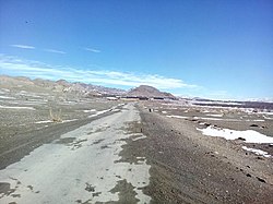
 View of Bala Niganda Village | |
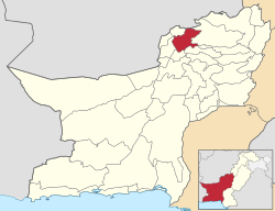
 Map of Balochistan with Pishin District highlighted | |
| Country | |
| Province | |
| Division | Quetta |
| Headquarters | Pishin |
| Government | |
| • Type | District Administration |
| • Deputy Commissioner | Zahid Khan |
| • District Police Officer | N/A |
| • District Health Officer | N/A |
| Area | |
• District of Balochistan | 6,218 km2 (2,401 sq mi) |
| Elevation | 1,555 m (5,102 ft) |
| Population (2017) | |
• District of Balochistan | 736,903 |
| • Density | 120/km2 (310/sq mi) |
| • Urban | 243,785 |
| • Rural | 591,697 |
| Time zone | UTC+5 (PST) |
| Calling code | 826[1] |
| National Assembly Seats (2023) | Total (1)
|
| Balochistan Assembly Seats (2023) | Total (3)
|
| Number of Tehsils | 5 |
| Website | quetta |
Pishin (Pashto: پښين, Urdu: ضلع پشین), IPA: pʂin/pçin, is a district in the Balochistan province of Pakistan. District Pishin is located at a strategic point and is 45km² from the provincial headquarters, Quetta. In 1975, it was bifurcated from Quetta District, while in 1993 part of it was split off to form the new district of Killa Abdullah.[2]
Again in 2022, part of it created the new district of Karezat. The name Pishin is a modernized form of ‘Pushang’, which is how the city was designated in (mainly pre-modern) Persian sources (Arabic sources using 'Fushang'). Myth attributes the origin of the Persian designation to a son of the mythical Emperor Afrasiab. Fushing was the spelling used in the records of Afghan government. The population of Pishin District was 300,000 in 2005.[3]
Administration
Pishin District is subdivided into five tehsils or sub-districts:
| Tehsil | Area
(km²)[4] |
Pop.
(2023) |
Density
(ppl/km²) (2023) |
Literacy rate
(2023)[5] |
Union Councils |
|---|---|---|---|---|---|
| Barshore Tehsil | 2,288 | 141,994 | 62.06 | 47.61% | ... |
| Hurramzai Tehsil | 418 | 147,844 | 353.69 | 39.67% | ... |
| Pishin Tehsil | 1,199 | 325,641 | 271.59 | 52.50% | ... |
| Saranan Tehsil | 83 | 65,157 | 785.02 | 48.33% | ... |
| Bostan Tehsil | 186 | 49,721 | 267.32 | 45.19% | ... |
Demographics
| Year | Pop. | ±% p.a. |
|---|---|---|
| 1961 | 58,957 | — |
| 1972 | 131,923 | +7.60% |
| 1981 | 202,256 | +4.86% |
| 1998 | 367,183 | +3.57% |
| 2017 | 736,903 | +3.73% |
| 2023 | 835,482 | +2.11% |
| Sources:[6] | ||
As of the 2023 census, Pishin district has 147,185 households and a population of 835,482. The district has a sex ratio of 104.34 males to 100 females and a literacy rate of 51.07%: 65.85% for males and 36.05% for females.[7][8] 318,031 (38.07% of the surveyed population) are under 10 years of age.[9] 243,785 (29.18%) live in urban areas.[7] 2,441 (0.29% of the surveyed population) are religious minorities, mainly Christians.[10] Pashto is the predominant language, spoken by 99.07% of the population.[11]
Pishin's main ethnic groups are Pashtuns who belong to the Tareen, Syed, Kakar, and Achakzai tribes. However, the Tareen tribe is known to be the ruling one among them.
| Religious group |
1941[12]: 13–14 | 2017[13][14] | ||
|---|---|---|---|---|
| Pop. | % | Pop. | % | |
| Islam |
1,245 | 65.87% | 35,067 | 98.65% |
| Hinduism |
447 | 23.65% | 3 | 0.01% |
| Sikhism |
183 | 9.68% | — | — |
| Christianity |
15 | 0.79% | 473 | 1.33% |
| Ahmadiyya |
— | — | 4 | 0.01% |
| Total population | 1,890 | 100% | 35,547 | 100% |
| Religious group |
1901[15] | 1911[16] | 1921[17] | 1931[18] | 1941[19] | |||||
|---|---|---|---|---|---|---|---|---|---|---|
| Pop. | % | Pop. | % | Pop. | % | Pop. | % | Pop. | % | |
| Islam |
96,600 | 84.67% | 106,702 | 83.59% | 103,456 | 75.47% | 107,945 | 73.16% | 113,288 | 72.49% |
| Hinduism |
11,752 | 10.3% | 13,746 | 10.77% | 22,300 | 16.27% | 26,718 | 18.11% | 28,629 | 18.32% |
| Christianity |
3,743 | 3.28% | 4,564 | 3.58% | 6,139 | 4.48% | 7,370 | 5% | 5,441 | 3.48% |
| Sikhism |
1,798 | 1.58% | 2,430 | 1.9% | 4,848 | 3.54% | 5,255 | 3.56% | 8,787 | 5.62% |
| Zoroastrianism |
151 | 0.13% | 137 | 0.11% | 151 | 0.11% | 161 | 0.11% | 73 | 0.05% |
| Judaism |
43 | 0.04% | 47 | 0.04% | 16 | 0.01% | 15 | 0.01% | 11 | 0.01% |
| Jainism |
0 | 0% | 9 | 0.01% | 8 | 0.01% | 32 | 0.02% | 7 | 0% |
| Buddhism |
— | — | 12 | 0.01% | 159 | 0.12% | 40 | 0.03% | 42 | 0.03% |
| Tribal | — | — | — | — | — | — | 0 | 0% | 0 | 0% |
| Others | 0 | 0% | 1 | 0% | 5 | 0% | 5 | 0% | 11 | 0.01% |
| Total population | 114,087 | 100% | 127,648 | 100% | 137,082 | 100% | 147,541 | 100% | 156,289 | 100% |
| Note: British Baluchistan era district borders are not an exact match in the present-day due to various bifurcations to district borders — which since created new districts — throughout the region during the post-independence era that have taken into account population increases. | ||||||||||
Agriculture and Farming
The main crops in the area are wheat, barley, corn (maize), potatoes, grapes, apple, pomegranate, almond, apricot, plum and peach which are grown in the valleys. Sheep and goats are also herded.[20]
Notable people
- Mohammad Ayub Khan, President of Pakistan
- Qazi Muhammad Essa, Senior Leader of the Pakistan Movement and a close associate of Quaid-e-Azam
- Jennifer Musa, Politician and Social worker
- Ashraf Jehangir Qazi, Diplomat, former Pakistani Ambassador to United States
- Qazi Faez Isa, Chief Justice Pakistan Supreme Court
See also
References
- ^ "National Dialing Codes". PTCL. Archived from the original on 9 November 2015. Retrieved 8 February 2022.
- ^ PCO 2000, p. 1.
- ^ "Home - Government of Balochistan". balochistan.gov.pk. Archived from the original on 2016-06-02. Retrieved 2016-05-14.
- ^ "TABLE 1 : AREA, POPULATION BY SEX, SEX RATIO, POPULATION DENSITY, URBAN POPULATION, HOUSEHOLD SIZE AND ANNUAL GROWTH RATE, CENSUS-2023, BALOCHISTAN" (PDF).
- ^ "LITERACY RATE, ENROLMENT AND OUT OF SCHOOL POPULATION BY SEX AND RURAL/URBAN, CENSUS-2023, BALOCHISTAN" (PDF).
- ^ "Population by administrative units 1951-1998" (PDF). Pakistan Bureau of Statistics.
- ^ a b "7th Population and Housing Census - Detailed Results: Table 1" (PDF). Pakistan Bureau of Statistics.
- ^ "7th Population and Housing Census - Detailed Results: Table 12" (PDF). Pakistan Bureau of Statistics.
- ^ "7th Population and Housing Census: Population by Mother Tongue, Sex and Rural/Urban" (PDF). Pakistan Bureau of Statistics.
- ^ "7th Population and Housing Census - Detailed Results: Table 9" (PDF). www.pbscensus.gov.pk. Pakistan Bureau of Statistics.
- ^ "7th Population and Housing Census: Population by Mother Tongue, Sex and Rural/Urban" (PDF). Pakistan Bureau of Statistics.
- ^ "CENSUS OF INDIA, 1941 VOLUME XIV BALUCHISTAN". Retrieved 27 January 2023.
- ^ "Final Results (Census-2017)". Retrieved 27 January 2023.
- ^ "District Wise Results / Tables (Census - 2017) TABLE 9 - POPULATION BY SEX, RELIGION AND RURAL/URBAN" (PDF). Retrieved 27 January 2023.
- ^ "Census of India 1901. Vol. 5A, Baluchistan. Pt. 2, Imperial tables". 1901. p. 5. JSTOR saoa.crl.25352844. Retrieved 8 September 2024.
- ^ "Census of India 1911. Vol. 4, Baluchistan : pt. 1, Report; pt. 2, Tables". 1911. p. 11. JSTOR saoa.crl.25393764. Retrieved 8 September 2024.
- ^ "Census of India 1921. Vol. 4, Baluchistan : part I, Report; part II, Tables". 1921. p. 165. JSTOR saoa.crl.25394124. Retrieved 8 September 2024.
- ^ "Census of India 1931. Vol. 4, Baluchistan. Pts. 1 & 2, Report [and] Imperial and provincial tables". 1931. p. 390. JSTOR saoa.crl.25797115. Retrieved 8 September 2024.
- ^ "Census of India, 1941. Vol. 14, Baluchistan". 1941. p. 17. JSTOR saoa.crl.28215993. Retrieved 8 September 2024.
- ^ "Pishin | Pakistan". Encyclopædia Britannica.
Bibliography
- 1998 District census report of Pishin. Census publication. Vol. 113. Islamabad: Population Census Organization, Statistics Division, Government of Pakistan. 2000.

