Peyremale
Peyremale | |
|---|---|
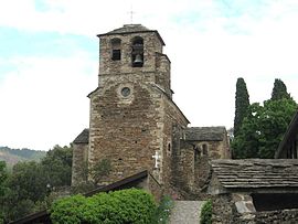
 The church of Peyremale | |
| Coordinates: 44°18′05″N 4°03′46″E / 44.3014°N 4.0628°E | |
| Country | France |
| Region | Occitania |
| Department | Gard |
| Arrondissement | Alès |
| Canton | Rousson |
| Government | |
| • Mayor (2020–2026) | Guy Silhol[1] |
Area 1 | 8.62 km2 (3.33 sq mi) |
| Population (2021)[2] | 275 |
| • Density | 32/km2 (83/sq mi) |
| Time zone | UTC+01:00 (CET) |
| • Summer (DST) | UTC+02:00 (CEST) |
| INSEE/Postal code | 30194 /30160 |
| Elevation | 162–619 m (531–2,031 ft) |
| 1 French Land Register data, which excludes lakes, ponds, glaciers > 1 km2 (0.386 sq mi or 247 acres) and river estuaries. | |
Peyremale (French pronunciation: [pɛʁmal]; Occitan: Pèiramala) is a commune in the Gard department in southern France.
Population
| Year | Pop. | ±% p.a. |
|---|---|---|
| 1968 | 371 | — |
| 1975 | 305 | −2.76% |
| 1982 | 274 | −1.52% |
| 1990 | 273 | −0.05% |
| 1999 | 281 | +0.32% |
| 2009 | 278 | −0.11% |
| 2014 | 289 | +0.78% |
| 2020 | 277 | −0.70% |
| Source: INSEE[3] | ||
About Peyremale
Peyremale is a typical Cévennes village that consists of several places and hamlets scattered along the rivers or Cèze and Luech and is bordering mountains.
Romanesque church of the 12th century, perched on a rocky outcrop, a view is offered on the old medieval hamlets Mercoire the Puech, the Elzière, as well as the most recent hamlets such as Claux, Mas Herm, the Chambonnet and Droulhèdes.
The people of Peyremale are called Peyremaliens.
See also
References
- ^ "Répertoire national des élus: les maires". data.gouv.fr, Plateforme ouverte des données publiques françaises (in French). 9 August 2021.
- ^ "Populations légales 2021" (in French). The National Institute of Statistics and Economic Studies. 28 December 2023.
- ^ Population en historique depuis 1968, INSEE


