Peralasseri
Peralasseri | |
|---|---|
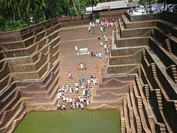
 Temple Pond in Peralassery | |
| Coordinates: 11°50′57″N 75°29′10″E / 11.849140°N 75.486010°E | |
| Country | |
| State | Kerala |
| District | Kannur |
| Taluk | Kannur |
| Government | |
| • Body | Peralasseri Grama Panchayat |
| Area | |
• Total | 10.76 km2 (4.15 sq mi) |
| Population (2011) | |
• Total | 16,821 |
| • Density | 1,600/km2 (4,000/sq mi) |
| Languages | |
| • Official | Malayalam, English |
| Time zone | UTC+5:30 (IST) |
| ISO 3166 code | IN-KL |
Peralasseri is a census town and Panchayat headquarters in Kannur district in the Indian state of Kerala, situated on the Kannur-Kuthuparamba State Highway 38 (Kerala), 12 km from Kannur city, on the bank of Anjarakandy river.[1]
Geography
Peralasseri is 14 kilometres (8.7 mi) from the district headquarters Kannur. The nearest town and railway stations are Thalassery which is 14 km (8.7 mi) and Kannur which is 15 km (9.3 mi) away. It is surrounded by 4 panchayats: Kadambur, Vengad, Anjarakandi, and Pinarayi.[citation needed]
Demographics
As of 2011 Census, Peralasseri had a population of 16,821 which constitutes 7,687 (45.7%) males and 9,134 (54.3%) females. Peralasseri census town spreads over an area of 10.76 km2 (4.15 sq mi) with 3,830 families residing in it. The male female sex ratio was 1,188 higher than state average of 1,084. In Peralasseri, 10.3% of the population is under 6 years of age. Peralasseri had an overall literacy of 97.9% higher than state average of 94%. The male literacy stands at 98.8% and female literacy was 97%.[2]
Religion
As of 2011 census, Peralasseri census town had total population of 16,821, which constitutes 79.4% Hindus, 20.4% Muslims and 0.2% others.[3]
Transportation
Kannur - Kuthuparamba state highway passes through Peralasser, which is about 14 km from Kannur International Airport.[citation needed]

The bridge of Peralasseri across the Anjarakandy River is one of the few hanging bridges in Kannur district.[citation needed]

Education
References
- ^ "Census of India 2001: Data from the 2001 Census, including cities, villages and towns (Provisional)". Census Commission of India. Archived from the original on 16 June 2004. Retrieved 1 November 2008.
- ^ Kerala, Directorate of Census Operations. District Census Handbook, Kannur (PDF). Thiruvananthapuram: Directorate of Census Operations, Kerala. p. 192,193. Retrieved 14 July 2020.
- ^ "Religion – Kerala, Districts and Sub-districts". Census of India 2011. Office of the Registrar General.
- ^ https://web.archive.org/web/20120426002022/http://peralasseryghss.in/
- ^ http://cbseaff.nic.in/cbse_aff/schdir_Report/AppViewdir.aspx?affno=931286/


