Passu
Passu پسو | |
|---|---|
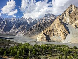
 Tupopdan and the Hunza River, from the Karakoram Highway in Passu, Pakistan | |
| Coordinates: 36°28′N 74°54′E / 36.467°N 74.900°E | |
| Province | |
| Time zone | UTC+5 |
Passu (Urdu: پسو) is a small village situated in the Gojal valley of Upper Hunza in the Gilgit Baltistan region of Northern Pakistan. Located along the Karakoram Highway, Passu is a renowned tourist destination.[1] The village is celebrated for its landscapes and breathtaking views of the 7,478-meter (24,534 ft) Passu Sar mountain, the Passu Glacier, and the Passu Cathedral (Tupopdan) 6,106m (20,033 ft).
Geography
Passu is situated along the Hunza River, approximately 20 kilometres (12 mi) from Gulmit, the administrative headquarters of Upper Hunza tehsil of Gojal. It is about 147 kilometres (91 mi) upriver from Gilgit. Passu lies in the Gojal Valley, within the subdivision of District Hunza.
Passu is located near the tongue of the Passu Glacier and just south of the Batura Glacier, which, at 56 kilometres (35 mi), is the seventh-longest non-polar glacier in the world and extends close to the highway.[2] Additionally, Borith Lake, a saline lake, located at 2,600 m above sea level, lies below the Hussaini village.[3]
Tupopdan, also known as "Passu Cones" or "Passu Cathedral," stands at 6,106 metres (20,033 ft) and is located north of the Passu village in Gojal Valley.[4] It is the most photographed peak of the region.[5] Nearby are the high peaks, including Pasu Sar, Shispare Sar, and Batura.
Demographics
The village is predominantly inhabited by Wakhi people, who migrated in waves from Wakhan between 1870 and 1948 to different areas of northern Pakistan.[4] They speak Wakhi language and are homogeneously Ismaili.[6][7]
See also
References
- ^ Mehboob Tanoli, Shazia (20 February 2022). "A treat for the senses". tribune.com.pk. The Express Tribune. Retrieved 13 July 2024.
- ^ Gao, Haifeng; Zou, Xiaojuan; Wu, Jianfeng; Zhang, Yinsheng; Deng, Xiaoya; Hussain, Saulat; Wazir, Muhammad Atif; Zhu, Guocai (22 January 2020). "Post-20th century near-steady state of Batura Glacier: observational evidence of Karakoram Anomaly". Scientific Reports. 10 (1): 987. doi:10.1038/s41598-020-57660-0. PMC 6976705. PMID 31969603. Retrieved 13 July 2024.
- ^ Abbas, Fakhar-i-; Manzoor, Madeeha; Shah, Imran; Mian, Afsar. "Black-Legged Kittiwake (Rissa tridactyla) in Karakoram: Record on Vagrancy". Journal of Bioresource Management. 3 (4). Wright State University. Retrieved 13 July 2024.
- ^ a b Rasheed, Zeeshan; Ali, Muhammad Kashif (28 December 2023). "History And Development of Cultural Proxies of Wakhi People of Gojal-Hunza Pakistan". International "Journal of Academic Research for Humanities". 3 (4): 239–248. Retrieved 13 July 2024.
- ^ Taylor, Alan (27 November 2017). "A Photo Trip Along the Ancient Silk Road". The Atlantic. Retrieved 18 September 2019.
- ^ Salopek, Paul (2 January 2018). "Walking Grass". National Geographic. Retrieved 2 January 2018.
The inhabitants of this austere landscape, many of them ethnic Wakhi farmers, have learned to trap this explosive blessing through the filter of grass.
- ^ Benz, Andreas (2013). "Education and Development in the Karakorum: Educational Expansion and Its Impacts in Gilgit-Baltistan, Pakistan". Erdkunde. 67 (2): 123–136. doi:10.3112/erdkunde.2013.02.02. ISSN 0014-0015. JSTOR 23595393. Retrieved 13 July 2024.
External links
 Media related to Passu at Wikimedia Commons

