Mount Zwegabin
| |
|---|---|
| |
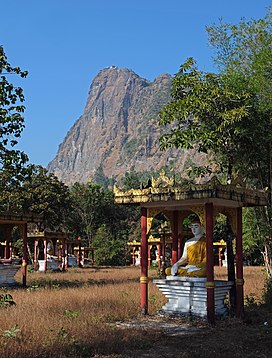
 The Buddha Statues Garden is located near the starting point of the stairs to the top of the mountain. Buildings in the top of the mountain belong to the Mount Zwegabin Monastery. | |
| Highest point | |
| Elevation | 722 m (2,369 ft) |
| Coordinates | 16°49′31″N 97°40′08″E / 16.8254°N 97.6690°E |
| Geography | |
| Location | Kayin State, Myanmar |
| Parent range | Tenasserim Hills |
Mount Zwegabin (Burmese: ဇွဲကပင် တောင်; S'gaw Karen: ကွဲၢ်ကဘီကစၢၢ်; Phlone: ခွဲါက္ၜင်) is a mountain in Myanmar. It is located in Kayin State, in the southern part of the country, around 450 km south of the capital Naypyidaw.[1] The top of Zwegabin is 722 metres (2,369 ft) above sea level.
The terrain around Mount Zwegabin is flat to the northwest, but hilly to the southeast. Mount Zwegabin is the highest point in the region. The area around Mount Zwegabin, is quite densely populated, with 155 inhabitants per square kilometer. The closest major city is Hpa-an, 8.2 km northwest of Mount Zwegabin. The surroundings around the mountains are a mosaic of agricultural land and natural vegetation.
See also
References
- ^ "GeoNames.org". www.geonames.org. Retrieved 14 October 2017.
External links
- "Viewfinder Panoramas Digital elevation Model" (2015-6-21).
- "Zwekabin Taung" said "Geonames.org (cc-by)" Geonames.org]; mail updated 2016-06-01; database download downloaded 2016-10-22
- "NASA Earth Observations: Population Density NASA/SEDAO
- "NASA Earth Observations: Land Cover Classification" NASA/MODES
- Peel, M C; Finlayson, B L."Updated world map of the Köppen-Geiger climate classification " Hydrology and Earth System Sciences 11: p. 1633–1644.
- "NASA Earth Observations Data set Index NASA
- "NASA Earth Observations: Rainfall (1 month-TRMM) NASA/Tropical Rainfall Monitoring Mission

