Eisspeedway

Momhil Sar

Momhil Sar
Mumhail Sar
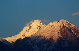
Momhil Sar in 2014
Highest point
Elevation7,414 m (24,324 ft)[1]
Ranked 64th
Prominence980 m (3,220 ft)
Parent peakTrivor
ListingList of mountains in Pakistan
Coordinates36°19′10″N 75°02′06″E / 36.319351°N 75.035108°E / 36.319351; 75.035108
Naming
Native nameمومہل سر
Geography
Momhil Sar is located in Pakistan
Momhil Sar
Momhil Sar
Location in Gilgit-Baltistan
Momhil Sar is located in Gilgit Baltistan
Momhil Sar
Momhil Sar
Momhil Sar (Gilgit Baltistan)
Map
About OpenStreetMaps
Maps: terms of use
45km
30miles
Pakistan
Diran
Diran
Yutmaru Sar
Yutmaru Sar
Baintha Brakk
Baintha Brakk
Yazghil Dome South
Yazghil Dome South
Ultar, Ultar Peak, Ultar Sar
Haramosh Peak
Haramosh Peak
Momhil Sar
Momhil Sar
Malubiting
Malubiting
Yukshin Gardan Sar
Yukshin Gardan Sar
Passu Sar
Passu Sar
Pumari Chhish
Pumari Chhish
Trivor Sar
Trivor Sar
Shispare or Shispare Sar
Batura III
Batura III
Kanjut Sar
Kanjut Sar
Batura II
Batura II
Rakaposhi
Rakaposhi
Batura Sar, Batura I
Kunyang Chhish (Kunyang Kish, Khunyang Chhish, Khinyang Chhish)
8
Kunyang Chhish (Kunyang Kish, Khunyang Chhish, Khinyang Chhish)
Distaghil Sar
7
Distaghil Sar
  
The major peaks in Karakoram are rank identified by height.

Legend:
1:K22:Gasherbrum I, K53:Broad Peak4:Gasherbrum II, K45:Gasherbrum III, K3a6:Gasherbrum IV, K37:Distaghil Sar8:Kunyang Chhish9:Masherbrum, K110:Batura Sar, Batura I11:Rakaposhi12:Batura II13:Kanjut Sar14:Saltoro Kangri, K1015:Batura III16: Saser Kangri I, K2217:Chogolisa18:Shispare19:Trivor Sar20:Skyang Kangri21:Mamostong Kangri, K3522:Saser Kangri II23:Saser Kangri III24:Pumari Chhish25:Passu Sar26:Yukshin Gardan Sar27:Teram Kangri I28:Malubiting29:K1230:Sia Kangri31:Momhil Sar32:Skil Brum33:Haramosh Peak34:Ghent Kangri35:Ultar Sar36:Rimo massif37:Sherpi Kangri38:Yazghil Dome South39:Baltoro Kangri40:Crown Peak41:Baintha Brakk42:Yutmaru Sar43:K644:Muztagh Tower45:Diran46:Apsarasas Kangri I47:Rimo III48:Gasherbrum V

 
Location in Gilgit-Baltistan
LocationShimshal, Gojal, Gilgit-Baltistan, Pakistan
Parent rangeKarakoram
Climbing
First ascent1964[2]
Momhil Sar
Traditional Chinese莫慕希爾峰
Transcriptions

Momhil Sar (Urdu: مومہل سر), or Mumhail Sar as pronounced in Wakhi is at 7,414 metres (24,324 ft) above sea level, is the 64th highest mountain peak in the world.[1] Mumhail Sar in Wakhi means the mountain that overlooks or is above Grandmother's cattle pen or paddock. It is situated in Shimshal Valley the Hispar Muztagh subrange of the Karakoram range, a few kilometres to the north-west of its parent peak Trivor.

A group from the Styrian High-touring Section of the Austrian Alpine Association, led by Hanns Schell [de], made the first ascent on June 29, 1964. Initially they attempted to climb the southeast ridge but were unsuccessful so a few days later they returned to Camp 3 and crossed the southeast wall of Momhil Sar, Rudolf Pischinger [de], Hanns Schell, Horst Schindelbacher [de], Leo Schlömmer [de] and Rudolf Widerhofer [de] then reached the summit via the south ridge.[2][3]

References

  1. ^ a b "Momhil Sar, Pakistan". Peakbagger.com. Retrieved 12 December 2019.
  2. ^ a b "Asia, Pakistan, Momhil Sar". American Alpine Journal. American Alpine Club. 1965. Retrieved 12 December 2019.
  3. ^ Schindlbacher, Horst (1966). "Momhil Sar (24,090 feet)". Himalayan Journal. #27: 107–114. Retrieved 9 September 2024.