Loralai District
Loralai District ضلع لورالائی لورالايي ولسوالۍ لۏرالائی دمگ | |
|---|---|
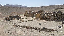
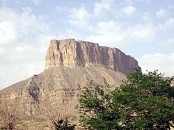
Top: View of Rana Ghundi Bottom: Chinjan | |
 Map of Balochistan with Loralai Division highlighted | |
| Coordinates: 30°20′N 69°00′E / 30.333°N 69.000°E | |
| Country | |
| Province | |
| Division | Loralai |
| Headquarters | Loralai |
| Government | |
| • Type | District Administration |
| • Deputy Commissioner | Kashif Nabi |
| • District Police Officer | N/A |
| • District Health Officer | N/A |
| Area | |
• District of Balochistan | 3,785 km2 (1,461 sq mi) |
| Population | |
• District of Balochistan | 272,432 |
| • Density | 72/km2 (190/sq mi) |
| • Urban | 59,601 |
| • Rural | 212,831 |
| Time zone | UTC+5 (PKT) |
| Main Language(s) | Pashto |
Loralai District (Urdu: ضلع لورالائی) is a district in the northeast of Balochistan province of Pakistan. The town of Loralai serves as the district headquarters.
Administration
| Tehsil | Area
(km²)[3] |
Pop.
(2023) |
Density
(ppl/km²) (2023) |
Literacy rate
(2023)[4] |
Union Councils |
|---|---|---|---|---|---|
| Bori Tehsil | 2,203 | 225,642 | 102.42 | 46.82% | ... |
| Mekhtar Tehsil | 1,582 | 46,790 | 29.58 | 24.55% | ... |
Demographics
| Year | Pop. | ±% p.a. |
|---|---|---|
| 1961 | 23,293 | — |
| 1972 | 41,615 | +5.42% |
| 1981 | 97,887 | +9.97% |
| 1998 | 134,171 | +1.87% |
| 2017 | 244,446 | +3.21% |
| 2023 | 272,432 | +1.82% |
| Sources:[5] | ||
Population
As of the 2023 census, Loralai district has 38,214 households and a population of 272,432. The district has a sex ratio of 110.13 males to 100 females and a literacy rate of 43.16%: 54.27% for males and 30.81% for females.[2][6] 101,407 (37.65% of the surveyed population) are under 10 years of age.[7] 59,601 (21.88%) live in urban areas.[2]
Religion
In the 2023 census, 1,611 (0.6%) were from religious minorities.[8]
| Religion | 1941[9][a] | 2017[10] | 2023[11] | |||
|---|---|---|---|---|---|---|
| Pop. | % | Pop. | % | Pop. | % | |
| Islam |
15,722 | 84.23% | 243,245 | 99.51% | 267,753 | 99.40% |
| Hinduism |
1,712 | 9.17% | 578 | 0.24% | 435 | 0.16% |
| Sikhism |
1,116 | 5.98% | — | — | 14 | 0.01% |
| Christianity |
75 | 0.40% | 540 | 0.22% | 1,096 | 0.41% |
| Others | 41 | 0.22% | 83 | 0.03% | 66 | 0.02% |
| Total Population | 18,666 | 100% | 244,446 | 100% | 269,364 | 100% |
| Religious group |
1911[12] | 1921[13] | 1931[14] | 1941[15] | ||||||
|---|---|---|---|---|---|---|---|---|---|---|
| Pop. | % | Pop. | % | Pop. | % | Pop. | % | |||
| Islam |
76,755 | 95.03% | 78,451 | 95.12% | 81,812 | 95.03% | 79,273 | 94.73% | ||
| Hinduism |
3,006 | 3.72% | 3,631 | 4.4% | 3,504 | 4.07% | 3,129 | 3.74% | ||
| Sikhism |
936 | 1.16% | 289 | 0.35% | 562 | 0.65% | 1,124 | 1.34% | ||
| Christianity |
71 | 0.09% | 101 | 0.12% | 209 | 0.24% | 159 | 0.19% | ||
| Zoroastrianism |
1 | 0% | 0 | 0% | 0 | 0% | 0 | 0% | ||
| Jainism |
0 | 0% | 1 | 0% | 0 | 0% | 0 | 0% | ||
| Judaism |
0 | 0% | 0 | 0% | 0 | 0% | 0 | 0% | ||
| Buddhism |
0 | 0% | 0 | 0% | 0 | 0% | 0 | 0% | ||
| Tribal | — | — | — | — | 0 | 0% | 0 | 0% | ||
| Others | 0 | 0% | 0 | 0% | 0 | 0% | 0 | 0% | ||
| Total population | 80,769 | 100% | 82,473 | 100% | 86,087 | 100% | 83,685 | 100% | ||
| Note: British Baluchistan era district borders are not an exact match in the present-day due to various bifurcations to district borders — which since created new districts — throughout the region during the post-independence era that have taken into account population increases. | ||||||||||
At the time of the 2023 census, 96.25% of the population spoke Pashto, 1.13% Balochi, 0.97% Saraiki and 0.72% Punjabi as their first language.[16]
Education
According to the Pakistan District Education Rankings, district Loralai is ranked at number 97 out of the 141 ranked districts in Pakistan on the education score index. This index considers learning, gender parity and retention in the district.
Literacy rate in 2014–15 of population 10 years and older in the district is estimated at 44% whereas for females it is only 22%.[17]
Post primary access is a major issue in the district with 89% schools being at primary level. Whereas high schools constitute only 3% of government schools in the district. This is also reflected in the enrolment figures for academic year 2016–17 with 12,192 students enrolled in class 1 to 5 and only 586 students enrolled in class 9 and 10.[citation needed]
Gender disparity is another issue in this district. Only 28% schools in the district are girls’ schools. Access to education for girls is a major issue in the district and is also reflected in the low literacy rates of females.[citation needed]
Moreover, the schools in the district lack basic facilities. According to Alif Ailaan district education rankings 2017, the district is ranked at number 135 out of the 155 districts of Pakistan for primary school infrastructure. At the middle school level, it is ranked at number 137 out of the 155 districts. These rankings take into account the basic facilities available in schools including drinking water, working toilet, availability of electricity, existence of a boundary wall and general building condition. 7 out of 10 schools do not have electricity in them whereas 3 out of 4 schools lack a toilet and more than half of the schools do not have a boundary wall. 2 out of 5 schools do not have clean drinking water.[citation needed]
Localities
References
- ^ PCO 1998, p. 1.
- ^ a b c "7th Population and Housing Census - Detailed Results: Table 1" (PDF). Pakistan Bureau of Statistics.
- ^ "TABLE 1 : AREA, POPULATION BY SEX, SEX RATIO, POPULATION DENSITY, URBAN POPULATION, HOUSEHOLD SIZE AND ANNUAL GROWTH RATE, CENSUS-2023, BALOCHISTAN" (PDF).
- ^ "LITERACY RATE, ENROLMENT AND OUT OF SCHOOL POPULATION BY SEX AND RURAL/URBAN, CENSUS-2023, BALOCHISTAN" (PDF).
- ^ "Population by administrative units 1951-1998" (PDF). Pakistan Bureau of Statistics.
- ^ "7th Population and Housing Census - Detailed Results: Table 12" (PDF). Pakistan Bureau of Statistics.
- ^ "7th Population and Housing Census: Population by Mother Tongue, Sex and Rural/Urban" (PDF). Pakistan Bureau of Statistics.
- ^ "Population by Sex, Religion and Rural/Urban, Census - 2023" (PDF). Pakistan Bureau of Statistics.
- ^ "Census of India, 1941. Vol. 14, Baluchistan". Retrieved 14 October 2021.
- ^ "Pakistan Census 2017 District-Wise Tables: Peshawar". Pakistan Bureau of Statistics.
- ^ "7th Population and Housing Census - Detailed Results: Table 9" (PDF). Pakistan Bureau of Statistics.
- ^ "Census of India 1911. Vol. 4, Baluchistan : pt. 1, Report; pt. 2, Tables". 1911. p. 11. JSTOR saoa.crl.25393764. Retrieved 8 September 2024.
- ^ "Census of India 1921. Vol. 4, Baluchistan : part I, Report; part II, Tables". 1921. p. 165. JSTOR saoa.crl.25394124. Retrieved 8 September 2024.
- ^ "Census of India 1931. Vol. 4, Baluchistan. Pts. 1 & 2, Report [and] Imperial and provincial tables". 1931. p. 390. JSTOR saoa.crl.25797115. Retrieved 8 September 2024.
- ^ "Census of India, 1941. Vol. 14, Baluchistan". 1941. p. 17. JSTOR saoa.crl.28215993. Retrieved 8 September 2024.
- ^ "7th Population and Housing Census: Population by Mother Tongue, Sex and Rural/Urban" (PDF). Pakistan Bureau of Statistics.
- ^ Pakistan Bureau of Statistics (2016). Pakistan Social and Living Standards Measurement Survey 2014-15. [online] Islamabad: Government of Pakistan, p.111. Available at: http://www.pbs.gov.pk/sites/default/files//pslm/publications/PSLM_2014-15_National-Provincial-District_report.pdf [Accessed 6 Aug. 2018].
- ^ Bori tehsil of erstwhile Loralai Agency, which roughly corresponds to the present district. District and tehsil borders have shifted since 1941.
Bibliography
- 1998 District Census report of Loralai. Census publication. Vol. 118. Islamabad: Population Census Organization, Statistics Division, Government of Pakistan. 2000.


