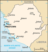
List of airports in Sierra Leone

This is a list of airports in Sierra Leone, sorted by location.
Sierra Leone, officially the Republic of Sierra Leone, is a country in West Africa. It is bordered by Guinea to the north, Liberia to the southeast, and the Atlantic Ocean to the southwest. Sierra Leone covers a total area of 71,740 km2 (27,699 sq mi) and has a population estimated at 6.4 million. The country is a constitutional republic comprising three provinces and the Western Area, which are further divided into fourteen districts. The capital and largest city of Sierra Leone is Freetown.
The country's main international airport is Freetown International Airport, located across the Sierra Leone River from Sierra Leone's capital, Freetown. All scheduled commercial airline services in Sierra Leone come to or take off from Lungi.
Airports
Names shown in bold indicate the airport has scheduled passenger service on commercial airlines.
| Location served | ICAO | IATA | Airport name |
|---|---|---|---|
| Bo | GFBO | KBS | Bo Airport |
| Sherbro, Bonthe | GFBN | BTE | Sherbro International Airport |
| Freetown | GFHA | HGS | Hastings Airport |
| Freetown | GFLL | FNA | Freetown International Airport |
| Gbangbatok | GFGK | GBK | Gbangbatok Airport |
| Kabala | GFKB | KBA | Kabala Airport |
| Kenema | GFKE | KEN | Kenema Airport |
| Yengema | GFYE | WYE | Yengema Airport |
See also
- Transport in Sierra Leone
- List of airports by ICAO code: G#GF - Sierra Leone
- Wikipedia: WikiProject Aviation/Airline destination lists: Africa#Sierra Leone
References
- "ICAO Location Indicators by State" (PDF). International Civil Aviation Organization. 2006-01-12.
- "UN Location Codes: Sierra Leone". UN/LOCODE 2009-1. UNECE. 2009-09-23. - includes IATA codes
- Great Circle Mapper: Airports in Sierra Leone - IATA and ICAO codes, coordinates
