Le Monnier (crater)
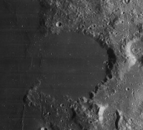
 Lunar Orbiter 4 image | |
| Coordinates | 26°36′N 30°36′E / 26.6°N 30.6°E |
|---|---|
| Diameter | 61 km |
| Depth | 2.4 km |
| Colongitude | 330° at sunrise |
| Eponym | Pierre Charles Le Monnier |

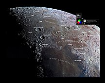
Le Monnier is the remnant of a lunar impact crater that has been partly inundated by lava flows. It was named after French astronomer Pierre Charles Le Monnier.[1] It is located on the eastern edge of Mare Serenitatis, and the western part of the rim is missing so that it now forms a large bay. To the north is the crater Chacornac.
The interior of this formation is relatively flat and smooth, with no significant craterlets to mark the surface. The outer rim is battered, worn, and notched with past impacts. Only slight wrinkle ridges now mark where the western rim once lay.
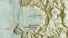
The landing site of the Luna 21 space probe is located near the southern rim of Le Monnier. Lunokhod 2, a robotic roving vehicle deposited on the surface by Luna 21, covered a distance of 37 kilometers across the crater floor. It also surveyed the southern edge of the crater rim.
Satellite craters

By convention these features are identified on lunar maps by placing the letter on the side of the crater midpoint that is closest to Le Monnier.


| Le Monnier | Latitude | Longitude | Diameter |
|---|---|---|---|
| A | 26.9° N | 32.5° E | 21 km |
| H | 25.0° N | 29.6° E | 6 km |
| K | 27.7° N | 30.2° E | 4 km |
| S | 26.8° N | 33.9° E | 40 km |
| T | 25.1° N | 31.4° E | 18 km |
| U | 26.1° N | 33.5° E | 25 km |
| V | 26.0° N | 34.3° E | 23 km |
The following craters have been renamed by the IAU.
- Le Monnier B — See Very (lunar crater).
- Le Monnier C — See Borel (crater).
References
- ^ "Le Monnier (crater)". Gazetteer of Planetary Nomenclature. USGS Astrogeology Research Program.
- Andersson, L. E.; Whitaker, E. A. (1982). NASA Catalogue of Lunar Nomenclature. NASA RP-1097.
- Bussey, B.; Spudis, P. (2004). The Clementine Atlas of the Moon. New York: Cambridge University Press. ISBN 978-0-521-81528-4.
- Cocks, Elijah E.; Cocks, Josiah C. (1995). Who's Who on the Moon: A Biographical Dictionary of Lunar Nomenclature. Tudor Publishers. ISBN 978-0-936389-27-1.
- McDowell, Jonathan (July 15, 2007). "Lunar Nomenclature". Jonathan's Space Report. Retrieved 2007-10-24.
- Menzel, D. H.; Minnaert, M.; Levin, B.; Dollfus, A.; Bell, B. (1971). "Report on Lunar Nomenclature by the Working Group of Commission 17 of the IAU". Space Science Reviews. 12 (2): 136–186. Bibcode:1971SSRv...12..136M. doi:10.1007/BF00171763. S2CID 122125855.
- Moore, Patrick (2001). On the Moon. Sterling Publishing Co. ISBN 978-0-304-35469-6.
- Price, Fred W. (1988). The Moon Observer's Handbook. Cambridge University Press. ISBN 978-0-521-33500-3.
- Rükl, Antonín (1990). Atlas of the Moon. Kalmbach Books. ISBN 978-0-913135-17-4.
- Webb, Rev. T. W. (1962). Celestial Objects for Common Telescopes (6th revised ed.). Dover. ISBN 978-0-486-20917-3.
- Whitaker, Ewen A. (1999). Mapping and Naming the Moon. Cambridge University Press. ISBN 978-0-521-62248-6.
- Wlasuk, Peter T. (2000). Observing the Moon. Springer. ISBN 978-1-85233-193-1.
External links
- Lunokhod 2 traverse overview, path of Lunokhod 2 in southern Le Monnier crater
- LTO-43A4 Le Monnier — L&PI topographic map.

