Jinonice
Jinonice | |
|---|---|
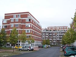
 Buildings of the Charles University in Jinonice | |
 Location of Jinonice in Prague | |
| Coordinates: 50°03′04″N 14°21′56″E / 50.05111°N 14.36556°E | |
| Country | Czech Republic |
| Region | Prague |
| District | Prague 5, Prague 13 |
| Area | |
• Total | 6.17 km2 (2.38 sq mi) |
| Population (2021)[1] | |
• Total | 7,556 |
| • Density | 1,200/km2 (3,200/sq mi) |
| Time zone | UTC+1 (CET) |
| • Summer (DST) | UTC+2 (CEST) |
| Postal code | 158 00 |
Jinonice is a cadastral district of Prague, mostly part of Prague 5, but a small area is part of Prague 13. It is located on the north edge of Prokopské údolí national park. Jinonice has been a part of Prague city since 1922.
Part of Jinonice is also the historical Slavic settlement Hradiště Butovice from the 9th century.
The most important local historical monument is the Church of St. Lawrence (Kostel svatého Vavřince), which was built in Romanesque style at the end of the 11th century.

In 1872 the Smíchov–Hostivice railway line was built. The area is also served by Jinonice metro station on line B of the Prague Metro
Demographics
|
| |||||||||||||||||||||||||||||||||||||||||||||||||||
| Source: Censuses[2][1] | ||||||||||||||||||||||||||||||||||||||||||||||||||||
Education
The Deutsche Schule Prag, the German international school, is in the district.[3]
- Shopping center Galerie Nové Butovice
- Karlštejnská street
- Educational trail of settlement Hradiště Butovice
References
- ^ a b "Results of the 2021 Census - Open data". Public Database (in Czech). Czech Statistical Office. 2021-03-27.
- ^ "Historický lexikon obcí České republiky 1869–2011 – Praha" (PDF) (in Czech). Czech Statistical Office. 2015-12-21.
- ^ "Kontakte Archived 2015-02-21 at the Wayback Machine." Deutsche Schule Prag. Retrieved on 20 February 2015. "Schwarzenberská 1/700 CZ-15800 Praha 5 – Jinonice"


