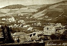
Jablonec nad Jizerou
Jablonec nad Jizerou | |
|---|---|
 General view | |
| Coordinates: 50°42′24″N 15°26′4″E / 50.70667°N 15.43444°E | |
| Country | |
| Region | Liberec |
| District | Semily |
| First mentioned | 1492 |
| Government | |
| • Mayor | Miroslav Kubát |
| Area | |
• Total | 22.32 km2 (8.62 sq mi) |
| Elevation | 450 m (1,480 ft) |
| Population (2024-01-01)[1] | |
• Total | 1,639 |
| • Density | 73/km2 (190/sq mi) |
| Time zone | UTC+1 (CET) |
| • Summer (DST) | UTC+2 (CEST) |
| Postal codes | 512 43, 514 01 |
| Website | www |
Jablonec nad Jizerou (German: Jablonetz an der Iser) is a town in Semily District in the Liberec Region of the Czech Republic. It has about 1,600 inhabitants.
Administrative parts
The villages of Blansko, Bratrouchov, Buřany, Dolní Dušnice, Dolní Tříč, Horní Dušnice, Hradsko, Končiny, Stromkovice and Vojtěšice are administrative parts of Jablonec nad Jizerou.
Etymology
The name Jablonec was probably derived from the Old Czech word jabloncje ("little apple tree"), which was a common tree in the location. Due to its location, there is one more possible explanation of the name origin, it could originate from the Latin gabella, meaning "the customs station".[2]
In 1916[3] or 1921, the attribute nad Jizerou ("above the Jizera") was added to distinguish from the city of Jablonec nad Nisou.[2]
Geography
Jablonec nad Jizerou is located about 13 kilometres (8 mi) northeast of Semily and 26 km (16 mi) east of Liberec. It lies on the Jizera River. The municipal territory lies in the Giant Mountains Foothills and extends into the Giant Mountains in the east. The highest point is the mountain Preislerův kopec at 1,035 m (3,396 ft) above sea level.
History

The first written mention of Jablonec is from 1492.[3]
Until the Thirty Years' War, Jablonec was a small non-agricultural village of thirteen houses, but the significance of the village indicates the existence of the parish church. The Thirty Years' War (1618–1648) had a catastrophic impact on Jablonec – only four houses remained. It took hundred years before Jablonec recovered from the war.[2]
An already medieval built-up area, which is probably to be found in the vicinity of the Church of Saint Procopius (originally wooden, from bricks since 1777 thanks to the support of Ernst Adalbert of Harrach) had more diffusive character, also the area from the second half of the 18th century was almost out of order on the slope of the valley.[2]

The only organizational factors were contour lines and parcels of land, a completely non-agricultural dwelling were chaotically centered on the link between the church and the mill. Thanks to the large reconstruction of the market town connected with the construction of the railway (1899) and the textile factories along the Jizera, Jablonec nad Jizerou gained the character of a modern mountainous town.[2]
In the second half of the 19th century, Jablonec grew rapidly, and in 1896, Jablonec was promoted to a market town by Emperor Franz Joseph I. At this time Jablonec was also given the new coat of arms.[3]
In 1971, Jablonec nad Jizerou was promoted to a town.[3]
Today among the new buildings from the turn of the 19th and 20th centuries and from the interwar period are sporadically preserved timbered houses.[3]
Demographics
|
|
| ||||||||||||||||||||||||||||||||||||||||||||||||||||||
| Source: Censuses[4][5] | ||||||||||||||||||||||||||||||||||||||||||||||||||||||||
Transport
The I/14 road from Liberec to Trutnov passes through the town.
Jablonec nad Jizerou is the terminus and start of the railway line from/to Martinice v Krkonoších.[6]
Sport

In Jablonec nad Jizerou is the Ski Resort Kamenec with 3,280 m (10,760 ft) of downhill slopes and two ski lifts. It is located on a hill at 688 m (2,257 ft) above sea level.[7]
Sights
The most important monument is the Janata's Mill in Buřany. It is a timbered watermill from 1767 with preserved and still functional equipment. Its current appearance is the result of building modifications from the 19th century. It is protected as a national cultural monument.[8]
The main landmark of Jablonec nad Jizerou is the Church of Saint Procopius. It was built in the Baroque style in 1777.[9]
Twin towns – sister cities
Jablonec nad Jizerou is twinned with:[10]
 Sulzbach, Germany
Gallery
- Church of Saint Procopius
- View towards the church
- Town hall
- Janata's Mill in Buřany
References
- ^ "Population of Municipalities – 1 January 2024". Czech Statistical Office. 2024-05-17.
- ^ a b c d e "Název města Jablonec nad Jizerou" (in Czech). Město Jablonec nad Jizerou. Retrieved 2021-08-20.
- ^ a b c d e "Historie města Jablonec nad Jizerou" (in Czech). Město Jablonec nad Jizerou. Retrieved 2021-08-20.
- ^ "Historický lexikon obcí České republiky 1869–2011" (in Czech). Czech Statistical Office. 2015-12-21.
- ^ "Population Census 2021: Population by sex". Public Database. Czech Statistical Office. 2021-03-27.
- ^ "Detail stanice Jablonec n.Jizerou" (in Czech). České dráhy. Retrieved 2024-06-01.
- ^ "SKI areál Kamenec" (in Czech). Město Jablonec nad Jizerou. Retrieved 2021-08-20.
- ^ "Areál vodního mlýna" (in Czech). National Heritage Institute. Retrieved 2023-03-28.
- ^ "Kostel sv. Prokopa" (in Czech). National Heritage Institute. Retrieved 2023-03-28.
- ^ "Zajímavé odkazy" (in Czech). Město Jablonec nad Jizerou. Retrieved 2020-08-14.
External links


