Phyllopod bed
| Part of a series on |
| The Burgess Shale |
|---|
 |
The Phyllopod bed, designated by USNM locality number 35k,[1] is the most famous fossil-bearing member of the Burgess Shale fossil Lagerstätte. It was quarried by Charles Walcott from 1911–1917 (and later named Walcott Quarry), and was the source of 95% of the fossils he collected during this time;[2] tens of thousands of soft-bodied fossils[3] representing over 150 genera[4] have been recovered from the Phyllopod bed alone.
Stratigraphy and location

The phyllopod bed is a 2.31 m thick layer of the 7 m thick Greater Phyllopod Bed,[4] found in the Walcott Quarry on Fossil Ridge, between Wapta Mountain and Mount Field, at an elevation of around 2,300 metres (7,500 ft), around 5 kilometres (3.1 mi) north of the railway town of Field, British Columbia, in the Canadian Rocky Mountains.[5] It is adjacent to Mount Burgess, where Walcott first discovered the Burgess Shale formation.
Walcott divided the bed into twelve units[6] based on the rock type and fossil content.[1] Certain fossil beds provide reference levels and can be recognized by the superabundance of a particular type of fossil: for instance, the Great Marrella layer and Great Eldonia layer.[7]
History

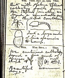
After locating soft-bodied fossils in loose fragments of rock in 1907, the Phyllopod bed was located in a source for the fragments' origins by the Walcotts in 1910.[8] Extensive quarrying was performed in field seasons until 1913, and Walcott considered the ton of shale he collected in his next visit, in 1917, to have practically exhausted the productive potential of the bed.[8]
Taphonomy
Most of the organisms within the Phyllopod bed had been transported minimal distances before they were buried, and decayed in place until they were buried (at which time decay and disarticulation was halted).[4] Mineralization of tissues occurred shortly afterwards.[4] The community of organisms preserved is a good representation of the (preservable) community; the biasing effects of time-averaging and preferential decay seem to be minimal.[4] A great deal of compaction occurred after the deposition of the fossils.[7]
Sedimentation
The unit consists of mudstones that intergrade into coarser shelly sandstones that sometimes form small nodules.[7] There are (very rare) turbidite layers, but on the whole the unit was deposited in large events that dumped tens of centimetres of sediment at a time as a slurry of mud was washed over the site by a density current, sweeping up and entombing any organisms in its path.[7]
Preservation
The preservation of the fossils – and their pre-burial livelihoods – was likely facilitated by mats of the cyanobacterium Morania, which served to bind the sediment and allow anoxic conditions to quickly form.[4]
Community structure

The phyllopod bed preserves a range of organisms from both a rich benthic community (organisms living on and in the sediment) and representatives of the nekton.[9] Many feeding modes are present and a complex food web can be inferred.[9] Whilst some shelly fossils are present (and seem to be typical of any Cambrian shelly fossil assemblage), the majority of fossils – probably 98% of what was alive at the time of burial – do not derive from biomineralized components.[9]
Ichnofauna
Whilst trace fossils or ichnofauna are locally abundant in other areas of the Burgess Shale, they are almost completely absent in the Phyllopod bed,[10] perhaps as a result of the presence of Morania.
References
- ^ a b Conway Morris, S. (1977). "A redescription of the Middle Cambrian worm Amiskwia sagittiformis Walcott from the Burgess Shale of British Columbia". Paläontologische Zeitschrift. 51 (3–4): 271–287. doi:10.1007/BF02986576. ISSN 0031-0220. S2CID 84554285.
- ^ Collins, D.; Briggs, D.; Conway Morris, S. (1983). "New Burgess Shale Fossil Sites Reveal Middle Cambrian Faunal Complex". Science. 222 (4620): 163–167. Bibcode:1983Sci...222..163C. doi:10.1126/science.222.4620.163. PMID 17741659. S2CID 12119240.
- ^ Conway Morris, S. (1989). "Burgess Shale Faunas and the Cambrian Explosion". Science. 246 (4928): 339–346. Bibcode:1989Sci...246..339C. doi:10.1126/science.246.4928.339. PMID 17747916. S2CID 10491968.
- ^ a b c d e f Caron, Jean-Bernard; Jackson, Donald A. (October 2006). "Taphonomy of the Greater Phyllopod Bed community, Burgess Shale". PALAIOS. 21 (5): 451–65. Bibcode:2006Palai..21..451C. doi:10.2110/palo.2003.P05-070R. JSTOR 20173022. S2CID 53646959.
- ^ Whittington, H. B. (16 November 1978). "The Lobopod animal Aysheaia pedunculata Walcott, Middle Cambrian, Burgess Shale, British Columbia". Philosophical Transactions of the Royal Society of London. Series B, Biological Sciences. 284 (1000): 165–197. Bibcode:1978RSPTB.284..165W. doi:10.1098/rstb.1978.0061. JSTOR 2418243.
- ^ Walcott, C. (1912). "Middle Cambrian Branchiopoda, Malacostraca, Trilobita, and Merostomata". Smithsonian Miscellaneous Collections. 57. Washington, D. C.: 145–228.
- ^ a b c d Gabbott, S. E.; Zalasiewicz, J.; Collins, D. (2008). "Sedimentation of the Phyllopod Bed within the Cambrian Burgess Shale Formation of British Columbia". Journal of the Geological Society. 165 (1): 307. Bibcode:2008JGSoc.165..307G. doi:10.1144/0016-76492007-023. S2CID 128685811.
- ^ a b Yochelson, E. L. (1 December 1996). "Discovery, Collection, and Description of the Middle Cambrian Burgess Shale Biota by Charles Doolittle Walcott". Proceedings of the American Philosophical Society. 140 (4): 469–545. ISSN 0003-049X. JSTOR 987289.
- ^ a b c Conway Morris, Simon (1986). "Community structure of the Middle Cambrian phyllopod bed (Burgess Shale)" (PDF). Palaeontology. 29 (3): 423–467. Archived from the original (PDF) on 16 July 2011.
- ^ Conway Morris, Simon (1979). "The Burgess Shale (middle Cambrian) fauna". Annual Review of Ecology and Systematics. 10: 327–349. doi:10.1146/annurev.es.10.110179.001551.
