
File:WorcestersSkyline.jpg
No higher resolution available.
WorcestersSkyline.jpg (640 × 219 pixels, file size: 43 KB, MIME type: image/jpeg)
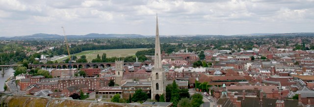
| Description | English: Glover's Needle, Deansway, Worcester
Taken from the top of the cathedral tower looking north-north-west. St. Andrew's church has been pulled down except for the perpendicular tower with the impressive spire. Worcester was famed for its glove making industry in the 19th century. Beyond and to the left is the railway viaduct over the river Severn and beyond that Worcester Racecourse. |
| Date | |
| Source | From geograph.org.uk |
| Author | Bob Embleton |
| Permission (Reusing this file) |
Creative Commons Attribution Share-alike license 2.0 |
| Attribution (required by the license) | Bob Embleton / Glover's Needle, Deansway, Worcester / |
| Camera location | | View this and other nearby images on: OpenStreetMap |
|---|

|
This image was taken from the Geograph project collection. See this photograph's page on the Geograph website for the photographer's contact details. The copyright on this image is owned by Bob Embleton and is licensed for reuse under the Creative Commons Attribution-ShareAlike 2.0 license. |
This file is licensed under the Creative Commons Attribution-Share Alike 2.0 Generic license.
Attribution: Bob Embleton
- You are free:
- to share – to copy, distribute and transmit the work
- to remix – to adapt the work
- Under the following conditions:
- attribution – You must give appropriate credit, provide a link to the license, and indicate if changes were made. You may do so in any reasonable manner, but not in any way that suggests the licensor endorses you or your use.
- share alike – If you remix, transform, or build upon the material, you must distribute your contributions under the same or compatible license as the original.
Original upload log
The original description page was here. All following user names refer to en.wikipedia.
- 2008-05-25 11:36 Asdfasdf1231234 640×219× (43717 bytes) {{Information |Description=Skyline of [[Worcester]], [[England]] |Source=[https://www.geograph.org.uk/photo/218487 Geograph] |Date= |Author=Bob Embleton |other_versions= }} {{geograph|218487|Bob Embleton}}
File history
Click on a date/time to view the file as it appeared at that time.
| Date/Time | Thumbnail | Dimensions | User | Comment | |
|---|---|---|---|---|---|
| current | 21:22, 19 October 2008 | 640 × 219 (43 KB) | Angusmclellan | {{Information |Description={{en|Glover's Needle, Deansway, Worcester Taken from the top of the cathedral tower looking north-north-west. St. Andrew's church has been pulled down except for the perpendicular tower with the impressive spire. Worcester was f |
File usage
The following 3 pages use this file:
Global file usage
The following other wikis use this file:
- Usage on ar.wikipedia.org
- Usage on azb.wikipedia.org
- Usage on cs.wikipedia.org
- Usage on hy.wikipedia.org
- Usage on it.wikipedia.org
- Usage on sk.wikipedia.org
- Usage on tr.wikipedia.org
- Usage on uk.wikipedia.org