
File:Woburn, Mass., 1883 LOC 78695092.tif

Size of this JPG preview of this TIF file: 800 × 527 pixels. Other resolutions: 320 × 211 pixels | 640 × 422 pixels | 1,024 × 675 pixels | 1,280 × 844 pixels | 2,560 × 1,688 pixels | 10,048 × 6,624 pixels.
Original file (10,048 × 6,624 pixels, file size: 190.42 MB, MIME type: image/tiff)
Summary
| Description | English: Perspective map not drawn to scale. Bird's-eye-view. LC Panoramic maps (2nd ed.), 331.1 Available also through the Library of Congress Web site as a raster image. AACR2 |
||
| Title | Woburn, Mass., 1883 | ||
| Shelf ID | G3764.W86A3 1883 .B8 | ||
| Date | |||
| Source | https://www.loc.gov/item/78695092/ | ||
| Author | Burleigh, L. R. (Lucien R.); Mason (D.) & Company, Publishers, Syracuse, N.Y.; Lyth, J.; Burleigh, L. R. | ||
| Permission (Reusing this file) |
|
||
| Other versions |
|
||
| Location | United States · Woburn · Massachusetts | ||
| Part of | American Memory · Cities And Towns · Catalog · Panoramic Maps · Geography And Map Division | ||
| Subject | Woburn (Mass.) · United States · Woburn · Aerial Views · Massachusetts |


Licensing
This is a faithful photographic reproduction of a two-dimensional, public domain work of art. The work of art itself is in the public domain for the following reason:
The official position taken by the Wikimedia Foundation is that "faithful reproductions of two-dimensional public domain works of art are public domain". This photographic reproduction is therefore also considered to be in the public domain in the United States. In other jurisdictions, re-use of this content may be restricted; see Reuse of PD-Art photographs for details. | ||||
File history
Click on a date/time to view the file as it appeared at that time.
| Date/Time | Thumbnail | Dimensions | User | Comment | |
|---|---|---|---|---|---|
| current | 04:08, 23 August 2018 | 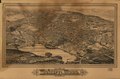 | 10,048 × 6,624 (190.42 MB) | Fæ | LOC Maps https://www.loc.gov/item/78695092/ #2561 |
File usage
The following page uses this file: