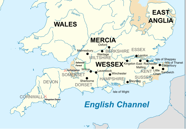
File:Southern British Isles 9th century.svg

Size of this PNG preview of this SVG file: 629 × 435 pixels. Other resolutions: 320 × 221 pixels | 640 × 443 pixels | 1,024 × 708 pixels | 1,280 × 885 pixels | 2,560 × 1,770 pixels.
Original file (SVG file, nominally 629 × 435 pixels, file size: 1.95 MB)
File history
Click on a date/time to view the file as it appeared at that time.
| Date/Time | Thumbnail | Dimensions | User | Comment | |
|---|---|---|---|---|---|
| current | 17:30, 19 July 2015 |  | 629 × 435 (1.95 MB) | Philg88 | User requested modifications |
| 16:00, 19 July 2015 |  | 629 × 435 (1.65 MB) | Philg88 | {{Information |Description ={{en|1=Map of the Southern British Isles during the 9th century}} |Source ={{own}} Incorporates elements of [https://commons.wikimedia.org/wiki/File:British_Isles_10th_century.svg this map] |Author =[[User... |
File usage
The following 6 pages use this file:
Global file usage
The following other wikis use this file:
- Usage on bn.wikipedia.org
- Usage on br.wikipedia.org
- Usage on cs.wikipedia.org
- Usage on el.wikipedia.org
- Usage on es.wikipedia.org
- Usage on fa.wikipedia.org
- Usage on fi.wikipedia.org
- Usage on he.wikipedia.org
- Usage on ja.wikipedia.org
- Usage on ko.wikipedia.org
- Usage on ms.wikipedia.org
- Usage on sk.wikipedia.org
- Usage on th.wikipedia.org
- Usage on tr.wikipedia.org
- Usage on zh.wikipedia.org
