
File:Paris-cite-haussmann.jpg
No higher resolution available.
Paris-cite-haussmann.jpg (602 × 402 pixels, file size: 99 KB, MIME type: image/jpeg)
Summary
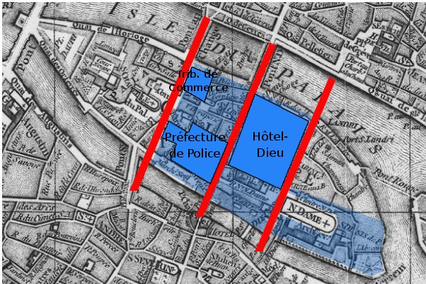
Paris, Ile de la Cité. A map based on the 1771 Robert de Vaugondy plan (cf File:Paris-cite-vaugondy-1771.jpg) and shows in dark blue the buildings, in light blue the public spaces and in red the streets created by Haussmann.
Derivated on a Gallica pic.
Previous public domain rationale, no longer applicable | ||
|---|---|---|
|
File history
Click on a date/time to view the file as it appeared at that time.
| Date/Time | Thumbnail | Dimensions | User | Comment | |
|---|---|---|---|---|---|
| current | 22:05, 16 February 2006 | | 602 × 402 (99 KB) | Thbz | Paris, Ile de la Cité. A map based on the 1771 Vaugondy plan (cf Image:Paris-cite-vaugondy-1771.jpg) and shows in dark blue the buildings, in light blue the public spaces and in red the streets created by Haussmann. Derivated on a Gallica pic. {{G |
File usage
The following page uses this file:
Global file usage
The following other wikis use this file:
- Usage on ca.wikipedia.org
- Usage on cs.wikipedia.org
- Usage on de.wikipedia.org
- Usage on fi.wikipedia.org
- Usage on fr.wikipedia.org
- Usage on he.wikipedia.org
- Usage on it.wikipedia.org
- Usage on ja.wikipedia.org
- Usage on ru.wikipedia.org
- Usage on uk.wikipedia.org