
File:Olomouc map 1757.jpg
Size of this preview: 635 × 599 pixels. Other resolutions: 254 × 240 pixels | 509 × 480 pixels | 640 × 604 pixels.
Original file (640 × 604 pixels, file size: 362 KB, MIME type: image/jpeg)
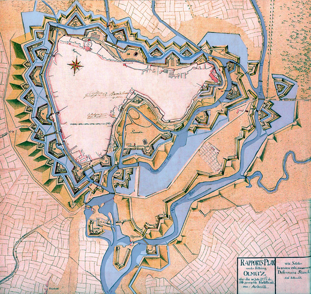
| Description | Čeština: Plán dokončené bastionové pevnosti Olomouc z r. 1757 se zaplavením, ale hladina ještě nedosáhla maxima. |
||||
| Date | |||||
| Source | http://www.pevnosti.cz/img/pevnosti231.jpg | ||||
| Author | |||||
| Permission (Reusing this file) |
|
||||
File history
Click on a date/time to view the file as it appeared at that time.
| Date/Time | Thumbnail | Dimensions | User | Comment | |
|---|---|---|---|---|---|
| current | 10:55, 24 January 2007 | | 640 × 604 (362 KB) | Snek01 | {{Information |Description= *{{English}} Historcal map of Olomouc fortress (Czech Republic) in 1757. *{{Czech}} Plán dokončené bastionové pevnosti Olomouc z r. 1757 se zaplavením, ale hladina ještě nedos |
File usage
The following 3 pages use this file:
Global file usage
The following other wikis use this file:
- Usage on az.wikipedia.org
- Usage on cs.wikipedia.org
- Usage on de.wikipedia.org
- Usage on es.wikipedia.org
- Usage on fr.wikipedia.org
- Usage on he.wikipedia.org
- Usage on hr.wikipedia.org
- Usage on it.wikipedia.org
- Usage on ja.wikipedia.org
- Usage on lt.wikipedia.org
- Usage on nl.wikipedia.org
- Usage on pl.wikipedia.org
- Usage on ro.wikipedia.org
- Usage on ru.wikipedia.org
- Usage on sh.wikipedia.org
- Usage on sk.wikipedia.org
- Usage on sl.wikipedia.org
- Usage on sv.wikipedia.org
- Usage on th.wikipedia.org
- Usage on tr.wikipedia.org
- Usage on www.wikidata.org
- Usage on zh.wikipedia.org