
File:New Mexico US Congressional District 1 (since 2013).tif

Size of this PNG preview of this TIF file: 800 × 385 pixels. Other resolutions: 320 × 154 pixels | 640 × 308 pixels | 1,024 × 493 pixels | 2,092 × 1,008 pixels.
Original file (2,092 × 1,008 pixels, file size: 2.64 MB, MIME type: image/tiff)
Summary
| Description | English: Boundaries for New Mexico’s 1st United States Federal Congressional District. |
| Date | |
| Source | GIS shapefile data created by the United States Department of the Interior, as part of the "1 Million Scale" geospatial data project. Retrieved from: http://nationalatlas.gov/atlasftp-1m.html?openChapters=#chpbound |
| Author | 1: GIS (congressional districts, 2013) shapefile data was created by the United States Department of the Interior. 2: Data was rendered using ArcGIS® software by Esri. 3: File developed for use on Wikipedia and elsewhere by 7partparadigm. |
Licensing
This map was obtained from an edition of the National Atlas of the United States. Like almost all works of the U.S. federal government, works from the National Atlas are in the public domain in the United States. Online access: NationalAtlas.gov | 1970 print edition: Library of Congress, Perry-Castañeda Library
|
File history
Click on a date/time to view the file as it appeared at that time.
| Date/Time | Thumbnail | Dimensions | User | Comment | |
|---|---|---|---|---|---|
| current | 21:23, 15 May 2014 | 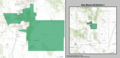 | 2,092 × 1,008 (2.64 MB) | 7partparadigm | User created page with UploadWizard |
File usage
The following 2 pages use this file:
Global file usage
The following other wikis use this file:
- Usage on es.wikipedia.org
- Usage on fr.wikipedia.org
- Usage on hu.wikipedia.org