
File:EremophilaAlpestrisIUCN.svg

Size of this PNG preview of this SVG file: 800 × 566 pixels. Other resolutions: 320 × 226 pixels | 640 × 453 pixels | 1,024 × 724 pixels | 1,280 × 905 pixels | 2,560 × 1,810 pixels | 1,052 × 744 pixels.
Original file (SVG file, nominally 1,052 × 744 pixels, file size: 25.95 MB)
Summary
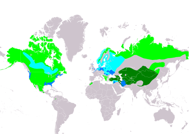
| Description | Slovenčina: Mapa rozšírenia druhu uškárik vrchovský Eremophila alpestris podľa IUCN verzia 2021.2 (Zostavil: BirdLife International and Handbook of the Birds of the World (2019) 2019.): legenda: Hniezdiaci, výskyt v letnom období (#00FF00), Hniezdiaci, celoročný výskyt (#008000), Migrujúci (#00FFFF), Nehniezdiaci (#007FFF) English: Distribution map of Horned Lark Eremophila alpestris according to IUCN version 2021.2 (Compiled by: BirdLife International and Handbook of the Birds of the World (2019) 2019.); key: Legend: Extant, breeding (#00FF00), Extant, resident (#008000), Extant, passage (#00FFFF), Extant, non-breeding (#007FFF) |
| Date | |
| Source | Made with Natural Earth. Free vector and raster map data @ naturalearthdata.com. Range map from BirdLife International. 2019. Eremophila alpestris. The IUCN Red List of Threatened Species 2019: e.T22717434A137693170. https://dx.doi.org/10.2305/IUCN.UK.2019-3.RLTS.T22717434A137693170.en. Downloaded on 05 November 2021 as visual indicator of distribution. |
| Author | SanoAK: Alexander Kürthy |
Licensing

This file is licensed under the Creative Commons Attribution-Share Alike 3.0 Unported license.
Attribution: IUCN Red List of Threatened Species, species assessors and the authors of the spatial data.
- You are free:
- to share – to copy, distribute and transmit the work
- to remix – to adapt the work
- Under the following conditions:
- attribution – You must give appropriate credit, provide a link to the license, and indicate if changes were made. You may do so in any reasonable manner, but not in any way that suggests the licensor endorses you or your use.
- share alike – If you remix, transform, or build upon the material, you must distribute your contributions under the same or compatible license as the original.
File history
Click on a date/time to view the file as it appeared at that time.
| Date/Time | Thumbnail | Dimensions | User | Comment | |
|---|---|---|---|---|---|
| current | 20:58, 5 November 2021 | | 1,052 × 744 (25.95 MB) | SanoAK | Uploaded a work by SanoAK: Alexander Kürthy from Made with Natural Earth. Free vector and raster map data @ naturalearthdata.com. Range map from BirdLife International. 2019. Eremophila alpestris. The IUCN Red List of Threatened Species 2019: e.T22717434A137693170. https://dx.doi.org/10.2305/IUCN.UK.2019-3.RLTS.T22717434A137693170.en. Downloaded on 05 November 2021 as visual indicator of distribution. with UploadWizard |
File usage
The following page uses this file:
Global file usage
The following other wikis use this file:
- Usage on ar.wikipedia.org
- Usage on arz.wikipedia.org
- Usage on ast.wikipedia.org
- Usage on bg.wikipedia.org
- Usage on ca.wikipedia.org
- Usage on cs.wikipedia.org
- Usage on cy.wikipedia.org
- Usage on de.wikipedia.org
- Usage on eo.wikipedia.org
- Usage on es.wikipedia.org
- Usage on eu.wikipedia.org
- Usage on fi.wikipedia.org
- Usage on fr.wikipedia.org
- Usage on ga.wikipedia.org
- Usage on gl.wikipedia.org
- Usage on hr.wikipedia.org
- Usage on hu.wikipedia.org
- Usage on hy.wikipedia.org
- Usage on id.wikipedia.org
- Usage on nl.wikipedia.org
- Usage on nn.wikipedia.org
- Usage on no.wikipedia.org
- Usage on pt.wikipedia.org
- Usage on ru.wikipedia.org
- Usage on sk.wikipedia.org
- Usage on sv.wikipedia.org
- Usage on uk.wikipedia.org
- Usage on www.wikidata.org
- Usage on zh.wikipedia.org