
File:Charlois 1867.png

Size of this preview: 714 × 599 pixels. Other resolutions: 286 × 240 pixels | 572 × 480 pixels | 915 × 768 pixels | 1,220 × 1,024 pixels | 1,600 × 1,343 pixels.
Original file (1,600 × 1,343 pixels, file size: 202 KB, MIME type: image/png)
Summary
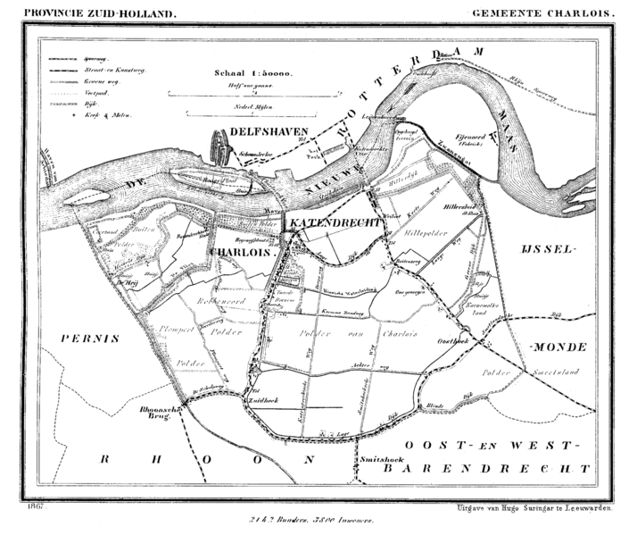
| Description | Historic map of Charlois (now part of municipality Rotterdam), South Holland, the Netherlands |
| Date | between 1865 and 1870 |
| Source | Gemeente Atlas van Nederland (Municipal Atlas of the Netherlands) |
| Author | J. Kuyper |
Licensing
|
This work is in the public domain in its country of origin and other countries and areas where the copyright term is the author's life plus 70 years or fewer. | |
| This file has been identified as being free of known restrictions under copyright law, including all related and neighboring rights. | |
File history
Click on a date/time to view the file as it appeared at that time.
| Date/Time | Thumbnail | Dimensions | User | Comment | |
|---|---|---|---|---|---|
| current | 17:33, 20 July 2007 | | 1,600 × 1,343 (202 KB) | P199 | {{Information |Description=Historic map of Charlois (now part of municipality Rotterdam), South Holland, the Netherlands |Source=Gemeente Atlas van Nederland (Municipal Atlas of the Netherlands) |Date=1865-1870 |Author=J. Kuyper |Permission= |other_versio |
File usage
The following page uses this file:
Global file usage
The following other wikis use this file: