Dunoir, Wyoming
Dunoir, Wyoming | |
|---|---|
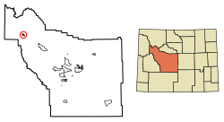
 Location of Dunoir in Fremont County, Wyoming. | |
| Coordinates: 43°33′57″N 109°48′57″W / 43.5657851°N 109.8157194°W | |
| Country | United States |
| State | Wyoming |
| County | Fremont |
| Area | |
• Total | 0.0235 sq mi (0.0611[1] km2) |
| Elevation | 8,369 ft (2,551 meters m) |
| Time zone | UTC-7 (Mountain (MST)) |
| • Summer (DST) | UTC-6 (MDT) |
| ZIP code | 82513 |
| Area code | 307 |
Dunoir, Wyoming, also spelled DuNoir, Wyoming, is an unincorporated community in Fremont County of western Wyoming in the United States. Dunoir is at an elevation of 8,369 feet (2,551 m) near Warm Spring Mountain. The main road in town is Union Pass road, #263 and Warm Spring Mountain road #532. Warm Spring Creek runs through the town. [1][2] Warm Spring Mountain has a summit of 9,524 feet (2,903 m) and is 1.54 miles (2.48 km) southeast of the town at 43°33′26″N 109°47′28″W / 43.5571°N 109.79115°W in the Shoshone National Forest in the Rocky Mountains. Dunoir is in the Wind River Range. The closest town is Dubois, Wyoming, 15 miles (24 km) southeast of Dunoir.[3][4]
Dunoir Special Management Unit
Dunoir Special Management Unit (SMU) is in the Shoshone National Forest and is a protected wildland with 28,000 acre. Dunoir Special Management Unit is in the upper Wind River Valley, northwest of Dubois. Motorized wheeled and tract vehicular recreation are not allowed in the Dunoir Special Management Unit. Dunoir Special Management Unit was founded on October 9, 1972, by Public Law 92-476. Dunoir Special Management Unit is in the Washakie Wilderness. [5][6]
See also
References
- ^ a b "Public Access Area | Wyoming Game & Fish Department". wgfd.wyo.gov.
- ^ "DuNoir Topo Map WY, Fremont County (Warm Spring Mountain Area)".
- ^ "Warm Spring Mountain - Peakbagger.com". peakbagger.com.
- ^ Dunoir WY Google Maps (accessed January 10, 2019)
- ^ Walker, Sarah (August 2, 2023). "Wildland Spotlight: Dunoir SMU". WWA.
- ^ Dunoir Special Management Unit, USFS, page 138


