Clifton Heights, St. Louis
Clifton Heights | |
|---|---|
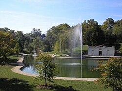
 Clifton Heights Lake | |
 Location (red) of Clifton Heights within St. Louis | |
| Country | United States |
| State | Missouri |
| City | St. Louis |
| Ward | 04 |
| Area | |
• Total | 0.48 sq mi (1.2 km2) |
| Population (2020)[1] | |
• Total | 2,836 |
| • Density | 5,900/sq mi (2,300/km2) |
| ZIP code(s) | Part of 63139 |
| Area code(s) | 314 |
| Website | stlouis-mo.gov |
Clifton Heights is a neighborhood of St. Louis, Missouri, US, located near the southwest border of the city and highlighted by a park — Clifton Heights Park (38°36′51″N 90°17′30″W / 38.6143°N 90.2916°W) — with a playground and a lake. Bounded on the north and west by I-44, on the east by Hampton Ave., and on the south by Arsenal St., Clifton Heights is in the 4th ward of the City of St. Louis, currently represented by Alderman Bret Narayan.[2] Its adjacent neighborhoods are Ellendale to the north and west, the Hill and Southwest Garden to the east, and Lindenwood Park to the south.
The neighborhood is mostly residential, with houses of varying architectural styles, including some Victorian and numerous Arts and Crafts homes. The curving streets surrounding the park and the hills that slope downward toward I-44 are somewhat unusual for St. Louis City, and give the neighborhood a distinctive feeling.[3][4] The streets were platted by the Prussian-born surveyor and city planner Julius Pitzman, whose work influenced the development of many other St. Louis neighborhoods.[5]
The Clifton Heights Neighborhood Association holds several annual events in the 4.4-acre park, including an Easter egg hunt, fall festival, and candy cane hunt.[6][7] In 2018, the City of St. Louis released a plan to guide future improvements to the park. The plan prioritizes repairing infrastructure, restoring the park's Victorian character, and improving the park's functionality (particularly in terms of accessibility).[8]
Clifton Heights is home to Mason School of Academic & Cultural Literacy, a school in the St. Louis Public School System serving pre-K to 6th grade students.[9] Richard Gephardt grew up on Reber Place and attended the school when it was known as Mason Elementary.[10] Clifton Heights has numerous small businesses, an AMVETS post,[11] and a Drury Inn and Suites. The construction of this hotel at the intersection of I-44 and Hampton Avenue was the subject of much neighborhood controversy regarding the demolition of homes and the placement of a large hotel next to small houses.[12]
Demographics
| Census | Pop. | Note | %± |
|---|---|---|---|
| 1990 | 4,130 | — | |
| 2000 | 3,485 | −15.6% | |
| 2010 | 3,074 | −11.8% | |
| 2020 | 2,836 | −7.7% | |
| Sources:[13][14] | |||
In 2020, Clifton Height's racial makeup was 86.2% White, 3.9% Black, 0.1% Native American, 2.3% Asian, 5.8% Two or More Races, and 1.6% Some Other Race. 3.3% of the population was of Hispanic or Latino origin.[15]
References
- ^ "2020 Census Neighborhood Results".
- ^ City of St. Louis Board of Aldermen: Ward 04 Alderman Bret Narayan
- ^ "Clifton Heights Neighborhood Overview". stlouis-mo.gov. Retrieved 2024-12-22.
- ^ "Final Report - Clifton Heights Survey, St. Louis, Missouri". Missouri State Parks. August 30, 1991. Retrieved January 2, 2025.
- ^ Naffziger, Chris (2014-10-08). "The Genius of Julius Pitzman, Designer of St. Louis' Private Streets". www.stlmag.com. Retrieved 2024-12-22.
- ^ "Clifton Heights Park". stlouis-mo.gov. Retrieved 2025-01-03.
- ^ "Welcome to Clifton Heights". Welcome to Clifton Heights. Retrieved 2024-12-22.
- ^ "Clifton Heights Park Master Plan". stlouis-mo.gov. Retrieved 2024-12-22.
- ^ "Mason School of Academic & Cultural Literacy Elementary School / Homepage". www.slps.org. Retrieved 2024-12-22.
- ^ "Richard A. Gephardt Collection: Collection Description | Introduction". gephardt.mohistory.org. Retrieved 2024-12-22.
- ^ "Amvets Post 6 (St. Louis, MO)". Facebook. Retrieved January 1, 2025.
- ^ Shawn Clubb, "Hotel developer seeks reprieve from building houses"[permanent dead link], Southwest City Journal, November 16, 2005. Posted to Urban St. Louis, retrieved June 8, 2009.
- ^ "Clifton Heights Neighborhood Statistics". St Louis, MO. Retrieved 26 January 2023.
- ^ "Neighborhood Census Data". City of St. Louis. Retrieved 26 January 2023.
- ^ "City of St. Louis" (PDF). Retrieved 2021-09-19.
38°36′43″N 90°17′42″W / 38.612°N 90.295°W
