Chenxi County
Chenxi County 辰溪县 Chenki | |
|---|---|
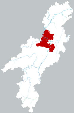
 Location of Chenxi County within Huaihua | |
| Coordinates: 28°00′22″N 110°11′06″E / 28.006°N 110.185°E[1] | |
| Country | People's Republic of China |
| Province | Hunan |
| Prefecture-level city | Huaihua |
| Seat | Chenyang |
| Area | |
• Total | 1,976.81 km2 (763.25 sq mi) |
| Population (2010)[3] | |
• Total | 453,565 |
| • Density | 230/km2 (590/sq mi) |
| Time zone | UTC+8 (China Standard) |
| Postal code | 4195XX |
Chenxi County (simplified Chinese: 辰溪县; traditional Chinese: 辰谿縣; pinyin: Chénxī Xiàn) is a county in Hunan Province, China, it is under the administration of Huaihua prefecture-level City.
Located on the north of the province, it is adjacent to the north of the city proper of Huaihua. The county is bordered to the north by Yuanling County, to the east by Xupu County, to the south by Zhongfang County and Hecheng District, to the west by Mayang and Luxi Counties. Chenxi County covers 1,990.3 km2 (768.5 sq mi), as of 2015, It had a registered population of 530,000 and a resident population of 461,400.[4] The county has nine towns and 14 townships under its jurisdiction, the county seat is Chenyang (辰阳镇).[5]
History
During the Second Sino-Japanese War, as part of the Third Front strategy, Chengxi developed into an industrial center. Many government offices and public services moved from Japanese occupied areas to Chengxi and the population increased from 5,000 to over 100,000. Japanese air raids caused hundreds of deaths and burned much of the old city.[6]
On 15 July 1996 the county was hit hard by floods.[6]
Climate
| Climate data for Chenxi (1991–2020 normals, extremes 1981–2010) | |||||||||||||
|---|---|---|---|---|---|---|---|---|---|---|---|---|---|
| Month | Jan | Feb | Mar | Apr | May | Jun | Jul | Aug | Sep | Oct | Nov | Dec | Year |
| Record high °C (°F) | 26.2 (79.2) |
29.5 (85.1) |
33.7 (92.7) |
35.0 (95.0) |
36.9 (98.4) |
37.6 (99.7) |
40.0 (104.0) |
39.5 (103.1) |
38.9 (102.0) |
35.0 (95.0) |
31.2 (88.2) |
23.5 (74.3) |
40.0 (104.0) |
| Mean daily maximum °C (°F) | 8.9 (48.0) |
11.8 (53.2) |
16.4 (61.5) |
22.6 (72.7) |
26.9 (80.4) |
29.9 (85.8) |
33.2 (91.8) |
33.2 (91.8) |
29.3 (84.7) |
23.1 (73.6) |
17.5 (63.5) |
11.6 (52.9) |
22.0 (71.7) |
| Daily mean °C (°F) | 5.6 (42.1) |
8.0 (46.4) |
12.0 (53.6) |
17.7 (63.9) |
22.1 (71.8) |
25.6 (78.1) |
28.5 (83.3) |
28.1 (82.6) |
24.3 (75.7) |
18.6 (65.5) |
13.1 (55.6) |
7.8 (46.0) |
17.6 (63.7) |
| Mean daily minimum °C (°F) | 3.3 (37.9) |
5.4 (41.7) |
9.0 (48.2) |
14.3 (57.7) |
18.6 (65.5) |
22.4 (72.3) |
24.9 (76.8) |
24.5 (76.1) |
20.7 (69.3) |
15.5 (59.9) |
10.1 (50.2) |
5.2 (41.4) |
14.5 (58.1) |
| Record low °C (°F) | −4.2 (24.4) |
−4.0 (24.8) |
−0.5 (31.1) |
3.4 (38.1) |
8.7 (47.7) |
13.3 (55.9) |
18.3 (64.9) |
16.9 (62.4) |
12.5 (54.5) |
4.6 (40.3) |
−0.4 (31.3) |
−3.5 (25.7) |
−4.2 (24.4) |
| Average precipitation mm (inches) | 54.1 (2.13) |
60.4 (2.38) |
104.2 (4.10) |
150.4 (5.92) |
223.1 (8.78) |
251.6 (9.91) |
224.8 (8.85) |
122.3 (4.81) |
83.9 (3.30) |
89.5 (3.52) |
67.9 (2.67) |
39.1 (1.54) |
1,471.3 (57.91) |
| Average precipitation days (≥ 0.1 mm) | 13.0 | 13.0 | 16.5 | 16.0 | 16.3 | 14.6 | 12.1 | 10.3 | 8.1 | 11.3 | 10.0 | 10.2 | 151.4 |
| Average snowy days | 4.2 | 2.1 | 0.3 | 0 | 0 | 0 | 0 | 0 | 0 | 0 | 0 | 1.5 | 8.1 |
| Average relative humidity (%) | 77 | 77 | 78 | 78 | 79 | 81 | 76 | 74 | 74 | 77 | 77 | 75 | 77 |
| Mean monthly sunshine hours | 53.2 | 57.9 | 80.4 | 110.7 | 135.2 | 139.1 | 221.4 | 225.5 | 164.1 | 115.6 | 95.4 | 75.4 | 1,473.9 |
| Percent possible sunshine | 16 | 18 | 22 | 29 | 32 | 33 | 52 | 56 | 45 | 33 | 30 | 23 | 32 |
| Source: China Meteorological Administration[7][8] | |||||||||||||
References
- www.xzqh.org (in Chinese)
- ^ "Chenxi" (Map). Google Maps. Retrieved 2014-07-02.
- ^ Huaihua City Land Use Plan (2006–20)/《怀化市土地利用总体规划(2006-2020年)》.(in Chinese) Accessed 8 July 2014.
- ^ "怀化市2010年第六次全国人口普查主要数据公报" (in Chinese). Huaihua Statistical Bureau/怀化市统计局. Archived from the original on 14 July 2014. Retrieved 9 July 2014.
- ^ about the population of Chenxi County in 2015, according to the Statistical Communiqué of Chenxi County on the 2015 National Economic and Social Development - (2015年辰溪县国民经济和社会发展统计公报): hhtj.gov.cn Archived 2017-02-02 at the Wayback Machine or chenxi.gov.cn Archived 2017-02-02 at the Wayback Machine
- ^ the divisions of Chenxi County in 2015, according to the result on adjustment of township-level administrative divisions of Chenxi County on November 19, 2015 - 《湖南省民政厅关于同意辰溪县乡镇区划调整方案的批复》(湘民行发〔2015〕52号): rednet.cn, also see 《湖南省乡镇区划调整改革109个县市区批复方案》: people.com Archived 2017-04-07 at the Wayback Machine or xinhuanet.com
- ^ a b "(视频+大量美图)6年前辰溪县城对岸的惊天一爆,底下的电厂见证日军暴行和国家由弱变强_爆破". www.sohu.com. Retrieved 2024-05-20.
- ^ 中国气象数据网 – WeatherBk Data (in Simplified Chinese). China Meteorological Administration. Retrieved 11 June 2023.
- ^ "Experience Template" 中国气象数据网 (in Simplified Chinese). China Meteorological Administration. Retrieved 28 May 2023.
External links

