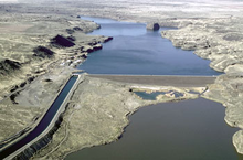
Pinto Dam
| Pinto Dam | |
|---|---|
 | |
| Location | Grant County, Washington, USA |
| Coordinates | 47°26′50″N 119°15′00″W / 47.44722°N 119.25000°W |
| Opening date | 1948[1] |
| Operator(s) | United States Bureau of Reclamation |
| Dam and spillways | |
| Height | 130 feet (40 m)[2] |
| Length | 1,900 feet (579 m)[2] |
| Width (base) | 600 feet (180 m)[2] |
| Reservoir | |
| Creates | Billy Clapp Lake |
| Total capacity | 21,200 acre-feet (0.0261 km3)[3] |
| Catchment area | 190 square miles (490 km2)[3] |
| Surface area | 973.6 acres (3.940 km2)[4] |
Pinto Dam is a dam in Grant County, Washington.
The dam was a project of the United States Bureau of Reclamation, completed from 1946 through 1948 as one element of the vast Columbia Basin Project for irrigation water storage, flood control, and hydroelectric power generation.[5] Pinto Dam is an earthen structure, 130 feet high and 1900 feet long at its crest, that provides offstream storage of water.[1]
The six-mile-long crescent-shaped reservoir it creates, Billy Clapp Lake, was originally called Long Lake Reservoir, but was renamed for one of the sponsors of the project, a lawyer from Ephrata, Washington.[6][7] The lake offers year-round fishing for yellow perch, crappie, rainbow trout, and walleye.[4] The Stratford Wildlife Recreation Area borders Billy Clapp Lake on its eastern shore and hosts migrating waterfowl. Another sizable lake, Brook Lake, also stands below the dam.
Columbia Basin Project
Pinto Dam and Billy Clapp Lake are part of the Main Canal (1951) of the Columbia Basin project.[8] The canal is 8.3 miles (13.4 km), from Banks lake to Billy Clapp Lake. From the Billy Clap Lakes outlet, the lower reach of the Main Canal continues westward to divide into the East Low and West Canals near Adco on Washington 28. The canals total length is about 21 miles (34 km) including about 5.33 miles (8.58 km) in Long Lake. By constructing Long Lake Dam, later renamed Pinto Dam, Reclamation utilized the coulee to avoid additional canal costs.[9]
Billy Clapp Lake
Billy Clapp Lake formed behind Pinto Dam along the length of Long Lake Coulee. The coulee is the result of the Missoula Floods. The reservoir is 6 miles (9.7 km) long and .5 miles (0.80 km) wide with a maximum depth of 300 feet (91 m) feet. Previous to the creation of the reservoir, the basin contained five smaller lakes, i.e., Long, Coffee Pot, Pot, Cold Spring and July Lakes.[8]
Pinto Dam
Pinto Dam, a zoned earth and rockfill structure, is 1,900 feet (580 m) long and 163 feet (50 m) high above bedrock. An uncontrolled open-channel emergency spillway is provided around the left abutment of the dam in a channel excavated in rock. Billy Clapp Headworks has radial gates to regulate the flow of water into the lower reach of the Main Canal.[8]
References
- ^ a b United States Bureau of Reclamation (2009-04-30). "Pinto Dam: General". Archived from the original on 2015-06-16. Retrieved 2015-01-23.
- ^ a b c The Story of the Columbia Basin Project. Washington D.C.: United States Government Printing Office. 1964. p. 59.
- ^ a b United States Bureau of Reclamation (2009-04-30). "Pinto Dam: Hydraulics and Hydrology". Archived from the original on 2015-06-16. Retrieved 2015-01-23.
- ^ a b Washington State Department of Fish & Wildlife. "Billy Clapp Lake". Retrieved 2015-01-23.
- ^ United States Bureau of Reclamation (2013-12-04). "Columbia Basin Project". Archived from the original on 2015-02-15. Retrieved 2015-01-23.
- ^ Washington Department of Fish & Wildlife. "Billy Clapp Lake Unit". Retrieved 2015-01-23.
- ^ Cassandra Tate (2005-03-10). "Grand Coulee Dam". Retrieved 2015-01-23.
- ^ a b c Draft Environmental Statement, Columbia Basin Project, Washington; Columbia Basin Project, Ephrata, Washington; Department of the Interior, (INT DES-75-3), Bureau of Reclamation, Department of the Interior; Washington, D.C.; 1975
- ^ The Columbia Basin Project; Wm. Joe Simonds; Bureau of Reclamation History Program; Denver, Colorado; Research on Historic Reclamation Projects; 1998
