Benfeld
Benfeld Banfald | |
|---|---|
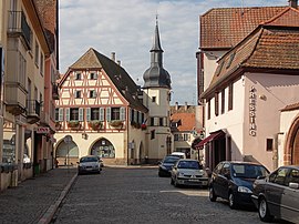
 The town hall in Benfeld | |
| Coordinates: 48°22′16″N 7°35′42″E / 48.371019°N 7.5950335°E | |
| Country | France |
| Region | Grand Est |
| Department | Bas-Rhin |
| Arrondissement | Sélestat-Erstein |
| Canton | Erstein |
| Government | |
| • Mayor (2020–2026) | Jacky Wolfarth[1] |
Area 1 | 7.79 km2 (3.01 sq mi) |
| Population (2021)[2] | 5,870 |
| • Density | 750/km2 (2,000/sq mi) |
| Time zone | UTC+01:00 (CET) |
| • Summer (DST) | UTC+02:00 (CEST) |
| INSEE/Postal code | 67028 /67230 |
| Dialling codes | 0388 |
| Elevation | 155–162 m (509–531 ft) (avg. 160 m or 520 ft) |
| 1 French Land Register data, which excludes lakes, ponds, glaciers > 1 km2 (0.386 sq mi or 247 acres) and river estuaries. | |
Benfeld (French pronunciation: [bɛnfɛld] ; Alsatian: Banfald [ˈbanfalt]) is a commune in the Bas-Rhin department in Grand Est in northeastern France.[3] It is situated on the river Ill. In the nearby hamlet Ehl there is an archaeological site with the remains of the Gallo-Roman city Ellelum or Helvetum. Benfeld station has rail connections to Strasbourg and Colmar.
The missionary to remote northern Australia, Francis Xavier Gsell, was born in Benfeld in 1872.
Population
|
| ||||||||||||||||||||||||||||||||||||||||||||||||||||||||||||||||||||||||||||||||||||||||||||||||||||||||||||||||||
| Source: EHESS[4] and INSEE (1968-2017)[5] | |||||||||||||||||||||||||||||||||||||||||||||||||||||||||||||||||||||||||||||||||||||||||||||||||||||||||||||||||||
Sights

The core of the town boasts several ancient buildings, chief among them the Renaissance town hall with its 1619 automata. The handsome 1846 synagogue survived the Nazi occupation.[6]
See also
References
- ^ "Répertoire national des élus: les maires". data.gouv.fr, Plateforme ouverte des données publiques françaises (in French). 2 December 2020.
- ^ "Populations légales 2021" (in French). The National Institute of Statistics and Economic Studies. 28 December 2023.
- ^ INSEE commune file
- ^ Des villages de Cassini aux communes d'aujourd'hui: Commune data sheet Benfeld, EHESS (in French).
- ^ Population en historique depuis 1968, INSEE
- ^ "La Synagogue de Benfeld (Dep. Bas Rhin / Alsace / Unterelsass)".


