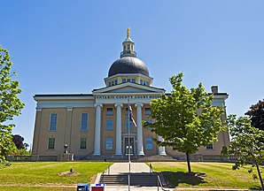
Ontario County
 | |
| Verwaltung | |
|---|---|
| US-Bundesstaat: | New York |
| Verwaltungssitz: | Canandaigua |
| Gründung: | 27. Januar 1789 |
| Gebildet aus: | Montgomery County |
| Vorwahl: | 001 585 |
| Demographie | |
| Einwohner: | 112.458 (Stand: 2020) |
| Bevölkerungsdichte: | 67,42 Einwohner/km2 |
| Geographie | |
| Fläche gesamt: | 1.715,9 km² |
| Wasserfläche: | 47,8 km² |
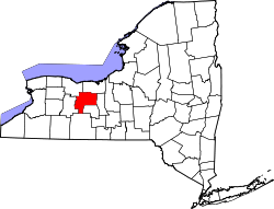
| Karte | |
 | |
| Website: www.co.ontario.ny.us | |
Ontario County[1] ist ein County im Bundesstaat New York der Vereinigten Staaten. Bei der Volkszählung im Jahr 2020 hatte das County 112.458 Einwohner und eine Bevölkerungsdichte von 67,4 Einwohner pro Quadratkilometer.[2] Der Verwaltungssitz (County Seat) ist Canandaigua.
Geographie
Das County hat eine Fläche von 1.715,9 Quadratkilometern, wovon 47,8 Quadratkilometer Wasserfläche sind.
Umliegende Gebiete
| Monroe County | Monroe County Wayne County |
Wayne County |
| Livingston County | 
|
Seneca County |
| Steuben County | Yates County | Seneca County |
Geschichte

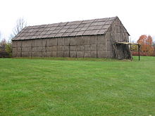
Ein Ort hat den Status einer National Historic Landmark, die frühere Siedlung der Seneca, Boughton Hill (Gannagaro).[3] 64 Bauwerke und Stätten des Countys sind insgesamt im National Register of Historic Places eingetragen (Stand 19. Februar 2018).[4]
Einwohnerentwicklung
| Jahr | 1700 | 1710 | 1720 | 1730 | 1740 | 1750 | 1760 | 1770 | 1780 | 1790 |
|---|---|---|---|---|---|---|---|---|---|---|
| Einwohner | 1075 | |||||||||
| Jahr | 1800 | 1810 | 1820 | 1830 | 1840 | 1850 | 1860 | 1870 | 1880 | 1890 |
| Einwohner | 15.218 | 42.032 | 88.267 | 40.288 | 43.501 | 43.929 | 44.563 | 45.108 | 49.541 | 48.453 |
| Jahr | 1900 | 1910 | 1920 | 1930 | 1940 | 1950 | 1960 | 1970 | 1980 | 1990 |
| Einwohner | 59.605 | 52.286 | 52.652 | 54.276 | 55.307 | 60.172 | 68.070 | 78.849 | 88.909 | 95.101 |
| Jahr | 2000 | 2010 | 2020 | 2030 | 2040 | 2050 | 2060 | 2070 | 2080 | 2090 |
| Einwohner | 100.224 | 108.085 | 112.458 |
Hinweis: Der Wert von 1810 ist lediglich aus der englischsprachigen Wikipedia ungeprüft übernommen worden, weil die Einwohnerzahlen für 1810 derzeit auf dem Server der Census-Behörde nicht verfügbar sind. (Stand: 11. November 2020)
Städte und Ortschaften
Zusätzlich zu den unten angeführten selbständigen Gemeinden gibt es im Ontario County mehrere villages.
| Ortschaft | Status | Einwohner (2010)[6] |
Gesamte Fläche [km²][7] |
Landfläche [km²][7] |
Bevölkerungsdichte [Einwohner / km²] |
Gründung[8] | Besonderheit |
|---|---|---|---|---|---|---|---|
| Bristol | town | 2.315 | 95,1 | 95,0 | 24,4 | Jan. 1789 | |
| Canadice | town | 1.664 | 84,0 | 77,3 | 21,5 | 15. Apr. 1829 | |
| Canandaigua City | city | 10.545 | 12,6 | 11,9 | 886,1 | 18. Apr. 1815 | County Seat; Gründung als village; 1913 zur city ernannt |
| Canandaigua Town | town | 10.020 | 162,0 | 147,1 | 68,1 | 27. Jan. 1782 | |
| East Bloomfield | town | 3.634 | 86,3 | 86,0 | 42,3 | 27. Jan. 1789 | Gründungsname: Bloomfield; umbenannt 1833 nach der Abtrennung von West Bloomfield |
| Farmington | town | 11.825 | 102,1 | 102,1 | 115,8 | 27. Jan. 1789 | |
| Geneva City | city | 13.261 | 10,9 | 10,9 | 1.216,6 | 3. März 1871 | Zur City ernannt: 1897[9] |
| Geneva Town | town | 3.291 | 49,5 | 49,4 | 66,6 | 4. Apr. 1806 | |
| Gorham | town | 4.247 | 137,7 | 126,5 | 33,6 | 27. Jan. 1789 | Gründungsname: Gaston; umbenannt in Lincoln 1806, in Gorham am 6. April 1807 |
| Hopewell | town | 3.747 | 92,5 | 92,4 | 40,6 | 29. März 1822 | |
| Manchester | town | 9.395 | 98,0 | 97,9 | 94,9 | 31. März 1821 | Gründungsname: Burt; umbenannt am 16. April 1822 |
| Naples | town | 2.502 | 102,8 | 102,8 | 24,3 | 27. Jan. 1789 | Gründungsname: Middletown; umbenannt am 6. April 1808 |
| Phelps | town | 7.072 | 169,0 | 168,2 | 42,0 | 1796 | |
| Richmond | town | 3.361 | 115,0 | 109,9 | 1796 | Gründungsname: Pittstown; umbenannt in Honcoye am 6. April 1808, in Richmond am 11. April 1815 | |
| Seneca | town | 2.721 | 130,7 | 130,7 | 20,8 | 1793 | |
| South Bristol | town | 1.590 | 108,8 | 100,9 | 15,8 | 8. März 1838 | |
| Victor | town | 5.822 | 93,0 | 93,0 | 62,6 | 26. Mai 1812 | |
| West Bloomfield | town | 2.466 | 66,0 | 65,9 | 37,4 | 11. Feb. 1833 |
Literatur
- John Homer French: Gazetteer of the State of New York. R.P Smith, Syracuse NY 1860, S. 491 ff. (Textarchiv – Internet Archive).
- Franklin Benjamin Hough: Gazetteer of the State of New York. Band 2. A. Boyd, Albany NY 1873, S. 491 ff. (Textarchiv – Internet Archive).
Weblinks
Einzelnachweise
- ↑ Ontario County. In: Geographic Names Information System. United States Geological Survey, United States Department of the Interior (englisch).
- ↑ U.S. Census Bureau QuickFacts: Ontario County, New York. Abgerufen am 28. August 2021 (englisch).
- ↑ New York. (PDF) Listing of National Historic Landmarks by State, National Park Service; abgerufen am 19. Februar 2018.
- ↑ Suchmaske Datenbank. National Register Information System, National Park Service; abgerufen am 19. Februar 2018.
- ↑ Einwohnerzahl 1790–2010 laut Volkszählungsergebnissen
- ↑ Einwohnerdaten aus dem US-Census von 2010. In: American Factfinder
- ↑ a b Offizielle Daten. United States Board on Geographic Names
- ↑ Franklin Benjamin Hough: Gazetteer of the State of New York. Band 2. A. Boyd, Albany NY 1873, S. 494 ff.
- ↑ Geschichtlicher Abriss. ( des vom 27. November 2020 im Internet Archive) Info: Der Archivlink wurde automatisch eingesetzt und noch nicht geprüft. Bitte prüfe Original- und Archivlink gemäß Anleitung und entferne dann diesen Hinweis. Website von Geneva City (englisch)
Koordinaten: 42° 51′ N, 77° 18′ W
