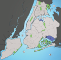
Datei:Waterways New York City Map Julius Schorzman.png

Größe dieser Vorschau: 616 × 600 Pixel. Weitere Auflösungen: 247 × 240 Pixel | 493 × 480 Pixel | 789 × 768 Pixel | 1.052 × 1.024 Pixel | 2.104 × 2.048 Pixel | 2.652 × 2.582 Pixel
Originaldatei (2.652 × 2.582 Pixel, Dateigröße: 1,88 MB, MIME-Typ: image/png)
Dateiversionen
Klicke auf einen Zeitpunkt, um diese Version zu laden.
| Version vom | Vorschaubild | Maße | Benutzer | Kommentar | |
|---|---|---|---|---|---|
| aktuell | 22:01, 30. Sep. 2013 |  | 2.652 × 2.582 (1,88 MB) | JohnnyMrNinja | Indexed colors, removed unused alpha channel and increased file compression |
| 03:36, 19. Aug. 2005 |  | 2.652 × 2.582 (6,19 MB) | Quasipalm | A map showing the major waterways in New York City. 1) Hudson River 2) East River 3) Long Island Sound 4) Newark Bay 5) Upper New York Bay 6) Lower New York Bay 7) Jamaica Bay 8) Atlantic Ocean Source: I created this image using various maps and images. |
Dateiverwendung
Die folgenden 9 Seiten verwenden diese Datei:
Globale Dateiverwendung
Die nachfolgenden anderen Wikis verwenden diese Datei:
- Verwendung auf af.wikipedia.org
- Verwendung auf ar.wikipedia.org
- Verwendung auf be.wikipedia.org
- Verwendung auf ca.wikipedia.org
- Verwendung auf cs.wikipedia.org
- Verwendung auf da.wikipedia.org
- Verwendung auf en.wikipedia.org
- Verwendung auf eo.wikipedia.org
- Verwendung auf es.wikipedia.org
- Verwendung auf eu.wikipedia.org
- Verwendung auf frr.wikipedia.org
- Verwendung auf fr.wikipedia.org
- Verwendung auf hak.wikipedia.org
- Verwendung auf he.wikipedia.org
- Verwendung auf id.wikipedia.org
- Verwendung auf it.wikipedia.org
- Verwendung auf ja.wikipedia.org
Weitere globale Verwendungen dieser Datei anschauen.
