
Datei:Locator map of Kanton Sélestat 2019.png

Größe dieser Vorschau: 608 × 599 Pixel. Weitere Auflösungen: 244 × 240 Pixel | 487 × 480 Pixel | 779 × 768 Pixel | 1.039 × 1.024 Pixel | 2.500 × 2.464 Pixel
Originaldatei (2.500 × 2.464 Pixel, Dateigröße: 1,05 MB, MIME-Typ: image/png)
![]()
Diese Datei und die Informationen unter dem roten Trennstrich werden aus dem zentralen Medienarchiv Wikimedia Commons eingebunden.
![]()
Beschreibung
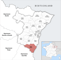
| Beschreibung | Deutsch: Lage des Kantons Sélestat |
||||||||
| Datum | |||||||||
| Quelle | Eigenes Werk | ||||||||
| Urheber | Tschubby | ||||||||
| Genehmigung (Weiternutzung dieser Datei) |
Ich, der Urheberrechtsinhaber dieses Werkes, veröffentliche es hiermit unter der folgenden Lizenz:
Diese Datei ist unter den Creative-Commons-Lizenzen „Namensnennung – Weitergabe unter gleichen Bedingungen 2.5 generisch“, „2.0 generisch“ und „1.0 generisch“ lizenziert.
Du darfst es unter einer der obigen Lizenzen deiner Wahl verwenden. |

Dateiversionen
Klicke auf einen Zeitpunkt, um diese Version zu laden.
| Version vom | Vorschaubild | Maße | Benutzer | Kommentar | |
|---|---|---|---|---|---|
| aktuell | 08:18, 20. Mai 2019 | | 2.500 × 2.464 (1,05 MB) | Tschubby | {{Information |Description= {{de|Lage des Kantons Sélestat}} |Source={{own}} |Date= 2019-01-01 |Author= Tschubby |Permission= {{self|GFDL|Cc-by-sa-3.0-migrated|Cc-by-sa-2.5,2.0,1.0}} |other_versions= }} Sélestat |
Dateiverwendung
Die folgende Seite verwendet diese Datei: